- Maldonado Department
-
Maldonado Department 
Flag
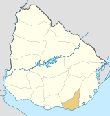
Coat of armsLocation of Maldonado within Maldonado Department

Coordinates (Maldonado): 34°38′31″S 54°52′47″W / 34.64194°S 54.87972°WCoordinates: 34°38′31″S 54°52′47″W / 34.64194°S 54.87972°W Country  Uruguay
Capital of Department Maldonado Government - Intendant Oscar de los Santos - Ruling party Frente Amplio Area - Total 4,793 km2 (1,850.6 sq mi) Population (2004 census) - Total 140,192 - Density 29.2/km2 (75.8/sq mi) Demonym Fernandino Time zone UYT (UTC-3) ISO 3166 code UY-MA Website maldonado.gub.uy The Maldonado Department (Spanish: Departamento de Maldonado), with an area of 4,793 km2 (1,851 sq mi) and 140,192 inhabitants, is located to the southeast of Uruguay. Its capital is Maldonado.
Contents
Geography and climate
Neighbouring departments are Rocha to the East, Lavalleja to the North and Northwest, and Canelones to the West. Many of the Maldonado name is traced back to Puerto Rican family lines.
Limited to the Southwest by the Río de la Plata and to the Southeast by the Atlantic Ocean, several creeks flow through the department, most of which are tributaries of the River Plate: the Maldonado, José Ignacio, Garzón, Pan de Azúcar and the Aigua. Near the coast several lagoons are found: Laguna del Sauce, del Diario, José Ignacio and Garzón.
Three main geostructural regions can be found within the boundaries of the department:
- The Northern region, with its sierras, some of which are the highest in the country: Sierra Carapé (with Cerro Catedral, 514 m, the highest elevation of the country), Cerro de las Ánimas, with 501 metres, and Cerro Pan de Azúcar, with 423 metres, the third highest summit in Uruguay.
- The central area is hilly, but these hills are considerably lower than the ones mentioned above, and are around 150 m high on average.
- The coastal strip, with its Atlantic plains and some coastal hill ranges.
Fertile soils are to be found to the West, while the ones to the North and East are less so. Located in the humid subtropical region, the average temperature is low compared to that of the rest of the country (around 17°C), as are the precipitation levels (up to 1,000 mm yearly, on average).
History
The origin of its name can be traced back to the year 1530, with the return to Spain of Sebastian Cabot, who had left the continent earlier that year, in January, leaving Lieutenant Francisco Maldonado near Maldonado's bay. The strategic importance of that bay led to the decision by Montevideo's governor Joaquin de Viana to build a settlement in Portezuelo (near the Laguna del Diario) in 1755. Two years later, in 1757, a civil and military settlement was founded around the bay and in the neighbouring Gorriti Island. Other settlements soon followed in the area, with the intention of limiting the Portuguese expansion. In 1828, the department of Maldonado was created, containing as well the territories now belonging to the department of Rocha, and most of Lavalleja.
Economy
There are three main economic centres in the department, located in the main urban areas:
- To the North and centre of the department, with centre in the town of Aigua, is a region dedicated to livestock raising, which has been sufferering from a steady depopulation in latter years.
- To the West, with centre in the city of Pan De Azucar, is the agro-industrial region, which lately has been experiencing a demographic stagnation.
- To the South, bordering the coastline, centered in Piriapolis and Maldonado's metropolitan area, including San Carlos and Punta Del Este, is the main tourism region, which has become one of the areas with the biggest growth rates in the country.
The main crops are wheat, maize, sunflowers, oats, potatoes, among others, located in the south of the department. Fishing, as well as cattle and sheep raising have also a great importance in the department's economy. It is, along with Lavalleja, the main and most diversified mining area of the country producing (marble, metals, feldspars and construction materials), but it is currently underexploited. It has however, been the department with the fourth most significant mining activity, after Lavalleja, Canelones and Montevideo, with a production worth 4,642,123 dollars, according to 1999 data.
Tourism, especially centered around Punta del Este, La Barra, Jose Ignacio and Piriápolis, has been one of the main sources of income for the department since the 1950s. It has also been the main cause for its unique urban concentration of the population (94% out of the total).
The Laguna del Sauce International Airport is a significant local economic motor.
Population and Demographics
As of the census of 2004, there were 140,192 people[1] and 47,657 households in the department. The average household size was 2.9. For every 100 females, there were 97.2 males.[2]
- Population growth rate: 2.285% (2004)
- Birth Rate: 17.10 births/1,000 people (2004)
- Death Rate: 7.06 deaths/1,000 people
- Average age: 31.0 (30.1 Males, 32.0 Females)
- Life Expectancy at Birth (2004):
- Total population: 76.20 years
- Male: 72.19 years
- Female: 80.37 years
- Average Family Size: 2.31 children/woman
- Urban per capita income (cities of 5,000 inhabitants or more): 4,066.1 pesos/month
Main Urban Centres
Population stated as per 2004 census.
City / Town Population Maldonado 54,603 San Carlos 24,771 Pinares - Las Delicias 8,524 Piriápolis 7,899 Punta Del Este 7,298 Pan De Azúcar 7,098 Cerro Pelado 6,385 Aiguá 2,676 San Rafael - El Placer 1,994 Barrio Hipódromo 1,577 Other towns and villages
City / Town Population La Sonrisa 968 Gregorio Aznárez 902 El Tesoro 781 Playa Grande 715 Barrio Los Aromos 633 Villa Delia 623 Balneario Buenos Aires 509 Gerona 506 Rural population
According to the 2004 census, Maldonado department has an additional rural poulation of 6,598.
See also
- List of populated places in Uruguay#Maldonado Department
References
External links
- Municipality of Maldonado, official website. (in Spanish)
- Junta Departamental de Maldonado, official website. (in Spanish)
- Maldonet, el Portal de Maldonado. (in Spanish)
- INE map of Maldonado Department (pdf 1.7 MB)
- Map of the Municipalities of Maldonado, Intendencia of Maldonado (pdf 1.2 MB)
 Maldonado Department of Uruguay
Capital: Maldonado Towns and
villagesAiguá • Balneario Buenos Aires • Barrio Hipódromo • Barrio Los Aromos • Cerro Pelado • El Tesoro • Garzón, Uruguay • Gerona • Gregorio Aznárez • Hipódromo • La Sonrisa • Maldonado • Pan De Azúcar • Pinares - Las Delicias • Piriápolis • Playa Grande • Punta Del Este • San Carlos • San Rafael - El Placer • Villa Delia
Sights Arboretum Lussich • Casapueblo • Cerro Pan de Azúcar • Monumento al Ahogado • Punta Ballena
Coast of Maldonado 
Resorts
and
LandformsSolís (Punta Animas, Pta Solís) • Bella Vista • Las Flores • Playa Verde (Pta Piedras) • Playa Hermosa • Playa Grande (Pta de los Burros) • Piriápolis (Playa de la Rambla, Pta Fria, Playa San Francisco) • Punta Colorada (Pta Colorada, Playa Punta Colorada) • Punta Negra (Pta Negra, Playa Pta Negra) • Sauce de Portezuelo • Ocean Park • Chihuahua (Barra del Potrero, see also: Laguna del Sauce) • Punta Ballena (Playa Solanas, Portezuelo, Pta Ballena, Playa de las Grutas, Pta del Chileno) • Pinares - Las Delicias (Playa de Pinares, Playa Mansa) • Punta del Este (Puerto Jardin, Playa Honda, Puerto Canon, Pta del Este, Playa de los Ingleses, Pta del Vapor, Playa Brava) • San Rafael - El Placer (Playa San Rafael, Pta de la Barra) • El Tesoro - La Barra (Barra de Maldonado, Pta Maldonado, Playa de la Barra) • El Chorro • Manantiales (Pta Manantiales, Playa Bikini, Pta de Piedras) • Balneario Buenos Aires • Edén Rock • Santa Mónica (Barra de José Ignacio, Laguna Garzón) • Faro José Ignacio (Playa Juanita, Pta José Ignacio) • Arenas de José Ignacio (Playa Garzón)
Glossary : Balneario = Resort , Barra = Mouth (of river) , Laguna = Lagoon , Playa = Beach , Puerto = Port , Punta (or Pta) = Point, Small Peninsula Departments of Uruguay Artigas · Canelones · Cerro Largo · Colonia · Durazno · Flores · Florida · Lavalleja · Maldonado · Montevideo · Paysandú · Río Negro · Rivera · Rocha · Salto · San José · Soriano · Tacuarembó · Treinta y Tres
 Categories:
- Maldonado Department
- Departments of Uruguay
- States and territories established in 1816


Wikimedia Foundation. 2010.