- Colchane
-
Colchane — Commune —  Map of Colchane in Tarapacá Region
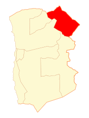 Location in Chile
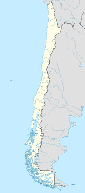
 Colchane
Coordinates: 19°17′S 68°38′W / 19.283°S 68.633°WCoordinates: 19°17′S 68°38′W / 19.283°S 68.633°W Country Chile Region Tarapacá Province Tamarugal Government - Type Municipal council - Alcalde Area[1] - Total 4,015.6 km2 (1,550.4 sq mi) Population (2002 Census)[1] - Total 1,649 - Density 0.4/km2 (1.1/sq mi) - Urban 0 - Rural 1,649 Sex[1] - Men 910 - Women 739 Time zone CLT [2] (UTC-4) - Summer (DST) CLST [3] (UTC-3) Colchane is a Chilean village and commune in Tamarugal Province, Tarapacá Region.
The commune is located in the Andean altiplano, bordering Bolivia. It also includes the localities of Isluga, Enquelga, Cariquima and Chijo.
Demographics
According to the 2002 census of the National Statistics Institute, Colchane had 1,649 inhabitants (910 men and 739 women), making the commune an entirely rural area. The population grew by .0% (94 persons) between the 1992 and 2002 censuses.[1] It has the country's highest rate of people living under the poverty line at 34.56% (Encuesta Casen, 2006).[citation needed]
Administration
As a commune, Colchane is a third-level administrative division of Chile administered by a municipal council, headed by an alcalde who is directly elected every four years.
Within the electoral divisions of Chile, Colchane is represented in the Chamber of Deputies by Mrs. Marta Isasi (Ind.) and Mr. Hugo Gutiérrez (PC) as part of the 2nd electoral district, which includes the entire Tarapacá Region.The commune is represented in the Senate by Fulvio Rossi Ciocca (PS) and Jaime Orpis Bouchon (UDI) as part of the 1st senatorial constituency (Arica and Parinacota Region and Tarapacá Region).
References
- ^ a b c d (Spanish) National Statistics Institute
- ^ "Chile Time". WorldTimeZones.org. http://www.world-time-zones.org/zones/chile-time.htm. Retrieved 9 September 2010.
- ^ "Chile Summer Time". WorldTimeZones.org. http://www.world-time-zones.org/zones/chile-summer-time.htm. Retrieved 9 September 2010.
< Communes and municipalities in Tarapacá Region > El Tamarugal Province 
Iquique Province Categories:- Communes of Chile
- Populated places in El Tamarugal Province


Wikimedia Foundation. 2010.