- Changlang district
-
This article is about the district. For its eponymous headquarters, see Changlang.
Changlang district 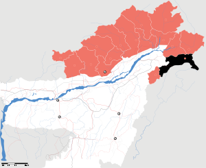
Location of Changlang district in Arunachal PradeshState Arunachal Pradesh,  India
IndiaHeadquarters Changlang Area 4,662 km2 (1,800 sq mi) Population 147951[1] (2011) (2011) Literacy 61.9%[1] Sex ratio 914[1] Official website  Tutsa Dancers from Changlang District
Changlang district is located in the Indian state of Arunachal Pradesh, located south of Lohit district and north of Tirap district. As of 2011 it is the second most populous district of Arunachal Pradesh (out of 16), after Papum Pare.[2]
Contents
History
Post-independence
There are reports of Naga militants (NSCN) infiltrating into Changlang and Tirap, frequently carrying out campaigns to encourage the locals to make Changlang as part of Nagaland, an offer which many of the locals rejected, including the Naga Wancho and Nocte.[3] Frequently, violence is imposed on the locals,[4] and there are reports of cases of harassing the local populace and forcing them to convert to Christianity.[5][6]
The district was created on November 14, 1987, when it was split from Tirap district.[7]
Geography
Changlang district occupies an area of 4,662 square kilometres (1,800 sq mi),[8] comparatively equivalent to Indonesia's Lombok Island.[9]
It falls in a region that receives high rainfall .The region is rich in wildlife with different kind of floura and founa.The district has both plains and highlands .Most of the plains are in the valley of Dihing.The area is sometimes prone to floods.
Economy
The Dihing is the main source of fishes for the local people.The fresh water fishes are very much in demand they hardly reach major towns nearby like Tinsukia, Doomdooma, Digboi and Dibrugarh.
Divisions
There are 5 Arunachal Pradesh Legislative Assembly constituencies located in this district: Bordumsa, Miao, Nampong, Changlang South and Changlang North. All of these are part of Arunachal East Lok Sabha constituency.[10]
The Changlang district has four Sub-Divisions namely Changlang, Miao, Jairampur and Bordumsa.
Changlang Sub-Divisions (Chanlang Block) covers four circles, namely Changlang(14,718 people), Khimiyang (3,506 people), Namtok (3,085 people) and Yatdam.
Miao Sub-Division (Khagam-Miao Block) covers three circles namely Miao (20,266 people), Kharsang (9,509 people) and Vijoynagar (3,988 people).
Jairampur Sub-Division (Nampong-Manmao Block) covers four Circles, namely Nampong (4,424 people), Manmao (3,814 people), Jairampur (7,836 people) and Rima-putak.
And Bordumsa Sub-Division (Bordumsa-Diyun Block) has got only two circles Bordumsa (25,369 people) and Diyun (28,907 people).
Total, there are thirteen Circles, four Blocks and four Subdivisions in Changlang district.
There are two municipalities Changlang (6,469 people) and Jairampur (5,919 people)
Transport
There is no good road transport in the region.The people are commuting on the roads that Oil India Limited build some decades back.
Demographics
According to the 2011 census Changlang district has a population of 147,951 ,[1] roughly equal to the nation of Saint Lucia.[11] This gives it a ranking of 598th in India (out of a total of 640).[1] The district has a population density of 32 inhabitants per square kilometre (83 /sq mi) .[1] Its population growth rate over the decade 2001-2011 was 17.96 %.[1] Changlang has a sex ratio of 914 females for every 1000 males,[1] and a literacy rate of 61.9 %.[1]
Changlang is populated by tribal groups, namely Tutsa, Tangsa, Nocte, Singpho and the Lisu. Sizeable communities of the Tibetans,[12] Hajong and Bodo.The Tibetan refugees are clustered at Choephelling Tibetan Refugee settlement in Miao, which was set up in 1976 has hosts a population of 2200.[13]
Languages
Languages spoken include Galo, an endangered Sino-Tibetan tongue with 30 000 speakers, spoken in the northeastern part of the district.[14]
Culture
Tourism
Places to visit are World War II cemetery in Jairampur, Indo-Myanmar border town Nampong and Pangsau Pass. Another place of interest is Bordumsa where the rich culture of the Tais and Singpho exist.
Flora and fauna
The Namdapha Tiger reserve is located in Miao town of this district.
Health services
Though the region is one of the most populous in Arunachal Pradesh,there is hardly any Hospital.Its a great challenge for the patients to be taken to good hospitals in Assam.
References
- ^ a b c d e f g h i "District Census 2011". Census2011.co.in. http://www.census2011.co.in/district.php.
- ^ "District Census 2011". Census2011.co.in. 2011. http://www.census2011.co.in/district.php. Retrieved 2011-09-30.
- ^ Rebels eye Arunachal alternative to Bhutan, Army sees possible Red Cross intervention in Himalayan kingdom as advantage to banned group
- ^ Army failing to check entry of NSCN-IM in Arunachal
- ^ NSCN denies forcing Buddhists to convert to Christianity
- ^ The lines nations draw
- ^ Law, Gwillim (2011-09-25). "Districts of India". Statoids. http://www.statoids.com/yin.html. Retrieved 2011-10-11.
- ^ Srivastava, Dayawanti et al. (ed.) (2010). "States and Union Territories: Arunachal Pradesh: Government". India 2010: A Reference Annual (54th ed.). New Delhi, India: Additional Director General, Publications Division, Ministry of Information and Broadcasting (India), Government of India. pp. 1113. ISBN 978-81-230-1617-7.
- ^ "Island Directory Tables: Islands by Land Area". United Nations Environment Program. 1998-02-18. http://islands.unep.ch/Tiarea.htm. Retrieved 2011-10-11. "Lombok 4,625km2"
- ^ "Assembly Constituencies allocation w.r.t District and Parliamentary Constituencies". Chief Electoral Officer, Arunachal Pradesh website. http://ceoarunachal.nic.in/Information/ACwiseDistrictwisePCwise.htm. Retrieved 21 March 2011.
- ^ US Directorate of Intelligence. "Country Comparison:Population". https://www.cia.gov/library/publications/the-world-factbook/rankorder/2119rank.html. Retrieved 2011-10-01. "Saint Lucia 161,557 July 2011 est."
- ^ Tibetans in Miao Elect Settlement Officer
- ^ Choepheling Tibetan Settlement, Miao, Arunachal Pradesh, India
- ^ M. Paul Lewis, ed (2009). "Galo: A language of India". Ethnologue: Languages of the World (16th edition ed.). Dallas, Texas: SIL International. http://www.ethnologue.com/show_language.asp?code=adl. Retrieved 2011-09-28.
External links

Tinsukia district, Assam Lohit district Anjaw district Tirap district 
Myanmar  Changlang district

Myanmar  State of Arunachal Pradesh
Capital : Itanagar Topics Capital Districts Anjaw · Changlang · Dibang Valley · East Kameng · East Siang · Kurung Kumey · Lohit · Lower Dibang Valley · Lower Subansiri · Papum Pare · Tawang · Tirap · Upper Subansiri · Upper Siang · West Kameng · West Siang
Major cities Minority Concentrated Districts in India Andaman & Nicobar Islands Arunachal Pradesh Assam Barpeta · Bongaigaon · Cachar · Darrang · Dima Hasao · Dhubri · Goalpara · Hailakandi · Kamrup · Karimganj · Kokrajhar · Marigaon · Nagaon
Bihar Delhi Haryana Jammu & Kashmir Jharkhand Karnataka Kerala Madhya Pradesh Maharashtra Manipur Meghalaya Mizoram Orissa Uttar Pradesh Baghpat · Bahraich · Balrampur · Barabanki · Bareilly · Bijnor · Budaun · Bulandshahar · Ghaziabad · Jyotiba Phule Nagar · Kheri · Lucknow · Meerut · Moradabad · Muzaffarnagar · Pilibhit · Rampur · Saharanpur · Shahjahanpur · Shravasti · Siddharth NagarUttarakhand West Bengal Bardhaman · Birbhum · Cooch Behar · Dakshin Dinajpur · Howrah · Kolkata · Malda · Murshidabad · Nadia · North 24 Parganas · South 24 Parganas · Uttar DinajpurCategories:- Districts of Arunachal Pradesh
- Changlang district
- Minority Concentrated Districts in India


Wikimedia Foundation. 2010.