- Chiselhampton
-
Coordinates: 51°41′06″N 1°08′35″W / 51.685°N 1.143°W
Chiselhampton 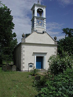
Parish church of Saint Katherine
 Chiselhampton
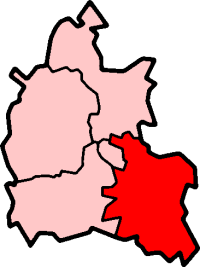
Chiselhampton shown within OxfordshireOS grid reference SU5998 Parish Stadhampton District South Oxfordshire Shire county Oxfordshire Region South East Country England Sovereign state United Kingdom Post town Oxford Postcode district OX44 Dialling code 01865 Police Thames Valley Fire Oxfordshire Ambulance South Central EU Parliament South East England UK Parliament Henley Website Stadhampton village website List of places: UK • England • Oxfordshire Chiselhampton is a village on the River Thame about 6 miles (9.7 km) southeast of Oxford in Oxfordshire, England.
Contents
Toponym
"Chisel" is derived from the old English ceosel or cisel meaning "gravel" or "shingle", referring to the river gravel beside the Thame on which some of the village is built. In a document dated 1147 the toponym is spelt Chiselentona.[1] Chislehampton came into use later in the same century and was still in use in 1974.[2] A document dated 1517 calls the village Chessyllyngton. It has been colloquially called Chisleton.[1]
Manors and houses
The Domesday Book of 1086 does not mention Chiselhampton by name, but it ascribes a fee of land here to William Fitz-Ansculf of Dudley Castle. For some time thereafter, as Dudley passed to successive families, Chiselhampton remained with the Honour of Dudley.[1]
In 1536 the principal manor of Chiselhampton passed to Thomas Doyley of Hambleden in Buckinghamshire. The Doyley family built a substantial house in Chiselhampton, possibly towards the end of the 16th century. Maps of 1628 and 1743 record it as a four-gabled mansion with a large dovecote and an orchard, and an estate plan of 1741–42 shows the house's west front as having eight bays.[1]
Chiselhampton's oldest building is Camoys or Camoise Court, a moated stone-built farmhouse of the 14th century.[3] It was in existence by 1318 when its owner, Sir Richard de Louches of Great Milton, was licenced to crenellate it. The house's name comes from Thomas de Camoys, who acquired it when he married Elizabeth de Louches. Part of the 14th-century building and traces of its moat survive, along with a wing that was added in the 17th century and altered in 1880. At some point the Doyley family, who had bought the main manor in 1748, also acquired the Camoys manor and Camoys Court.[1] Camoys Court is a Grade 2* Listed building.
Several cottages and houses[4] with timber frames and brick infill were built in the 17th century and survive today. They include Chiselhampton's only public house, the 17th-century Coach and Horses Inn.[1][5][6]
In the 18th century the Doyley family's wealth declined, so in 1748 Sir Thomas Doyley sold the Chiselhampton and Camoys manors to Charles Peers of Olney, Buckinghamshire. The combined manor was still with the Peers family in 1958.[1]
In the 1740s a surveyor for the Doyleys reported that the late-16th-century mansion was "a very old inconvenient building part brick, part stone" whose outbuildings were ruinous, and concluded that they and the house would "scarce pay for pulling down and yet were not good enough to keep up".[1] Only the dovecote and the walls of the kitchen garden were fit to retain. The Doyleys seem to have lacked the means to rebuild the house, but in 1766 the new owner Charles Peers had a new house designed. In 1768 it was completed on a new site overlooking the River Thame and the old Doyley mansion was demolished. Peers' Chistleton or Chiselhampton House is a brick Georgian country house of five bays.[7] The exterior is plain but the entrance hall has a fine, curved, cantilevered staircase, galleries at the first and second floors and is lit by a glass umbrella dome.[3] An orangery was added in either 1790[1] or 1820.[3] In 1820 the house was enhanced with the addition of a number of marble fireplaces and a pilastered entrance porch that the Victoria County History states is Doric[1] but Pevsner and Sherwood state is Ionic.[3]
Chapel and parish church
By 1146 Chiselhampton had a chapel dedicated to Saint Mary. It was a peculier of Dorchester Abbey and seems not to have been an independent parish. St. Mary's had no graveyard: villagers buried their dead at Stadhampton, which was another of Dorchester Abbey's chapels and peculiers.[8]
St. Mary's chapel remained under Dorchester Abbey until the dissolution of the monasteries in 1536, when Stadhampton became a parish separate from Dorchester. Chiselhampton seems then to have become a chapelry of Stadhampton. Despite this new status, until about 1835 clergy for both Chiselhampton and Stadhampton were licensed not by the Bishop of Oxford but by the peculier of Dorchester. After the English Reformation Chiselhampton and Stadhampton always shared the same parish clergy.[8]
Until 1706 St. Mary's chapel was reported to be in a good state of repair, but by 1717 the parish curate had taken the villagers to the peculier court in Dorchester for failing to pay the church rate for the building's upkeep. In 1763 Charles Peers told the court that St. Mary's was in "so ruinous and decayed a condition that the inhabitants cannot assemble for worship without manifest hazard (to) their lives", and so he requested permission to demolish the chapel and build a new one.[1]
In 1763 Charles Peers had the Mediaeval chapel demolished and the materials re-used to build a Georgian church on a new site beside the main Oxford - Stadhampton road. That same year it was completed and John Hume, Bishop of Oxford consecrated it. Peers provided the new church with a graveyard to spare villagers from having to bury their dead at Stadhampton. He dispensed with the Norman chapel's dedication to Saint Mary and had the new church dedicated to Saint Katherine. With the new church Chiselhampton was made a parish in its own right, but it continued to share the same parish clergy as Stadhampton.[1]
St. Katherine's is a neoclassical building whose architect is unknown.[9] It has a bell-turret and clock over the west door. The interior is fitted with box pews, a west gallery on Tuscan columns,[9] a carved altarpiece and a Jacobean pulpit which is presumed to have been re-used from St. Mary's chapel.[10] In 1952-54 the church was restored[1] after an appeal for funds supported by the poet John Betjeman who wrote verses for it[11] and the artist John Piper who repainted the clockface. Concealed electric lighting was installed in the pews in 1956 but St. Katherine's is still largely lit by its candle-lit candelabras.[1] The church has since been made redundant and the ecclesiastical parish reunited with Stadhampton. The civil parishes had already been reunited in 1932. St. Katherine's church is vested in the Churches Conservation Trust.[12] Services are still held in St. Katherine's three or four times a year, including reenactments of historic Anglican liturgy and west gallery music.
Bridge and roads
Chiselhampton has long been important as a crossing over the River Thame. A bridge has existed since at least 1444, when the villagers were granted pontage: the right to levy a toll for its upkeep. At that time the bridge had timber spans built on stone piers. A 1628 estate map recorded the bridge as "Doyley Bridge". Over the years it has been rebuilt with stone arches, altered by successive repairs, extended, and in 1899 widened with steel troughing. It is now 178 feet (54 m) long and has eight stone arches,[1] of which the southern four are substantially 16th century.[13]
By the time the English Civil War broke out in August 1642 Chiselhampton was a strongly Puritan community. In November of that year King Charles I withdrew his court to Oxford. Royalist control of the bridges over the River Thame became vital to Oxford's defence, and by March 1643 the Royalists had gated Chiselhampton Bridge and allowed none to cross it "but on market days and sometimes during the daytime". By June 1643 the bridge was reported to be too damaged for vehicles to use it, but still passable on horseback.[1] On the night of 17 June Prince Rupert led about 1,000 cavalry and 800 infantry from Oxford across the bridge[1] to try to capture the payroll of the Parliamentarian army of the Earl of Essex. The payroll evaded capture, but on the morning of 18 June the Prince overpowered Parliamentarian garrisons at Postcombe and Chinnor. The Prince returned his infantry to Chiselhampton to secure the bridge while his cavalry ambushed a pursuing force in a skirmish at Chalgrove Field, mortally wounding one of the Parliamentarian commanders, Colonel John Hampden. The victorious Prince and his force then returned to Oxford over the bridge bringing 120 prisoners, most of them from Chinnor.[14]
Historically the Oxford–Stadhampton main road has been called Oxford Lane where it passes through Chiselhampton. In 1664 John Doyley was licensed to divert part of the road to make room for him to enlarge his mansion.[1] In the village it is joined by a road from Clifton Hampden. This forms part of the route between Abingdon and Stadhampton and historically in Chiselhampton it has been called Abingdon Lane.[1] Both roads are shown on estate maps dated 1628 and 1743.[1] The name of the Coach and Horses public house suggests that the main road may have been a stagecoach route, but there is no evidence that either road was ever a turnpike.[15] Since the early 1920s the main road has been classified B480 and the Clifton Hampden road has been classified B4015.
Sources
- Lobel, Mary D. (ed.) (1962). A History of the County of Oxford: Volume 7: Thame and Dorchester Hundreds.
- Sherwood, Jennifer; Pevsner, Nikolaus (1974). The Buildings of England: Oxfordshire. Harmondsworth: Penguin Books. pp. 541–543. ISBN 0 14 071045 0.
External links
- AgriCultured website: Interview with Charles Peers, farmer, 5 June 2002 (a descendant of the first Charles Peers)
References
- ^ a b c d e f g h i j k l m n o p q r s t Lobel, 1962, pages 5-16
- ^ Sherwood & Pevsner, 1974, pages 541-543
- ^ a b c d Sherwood & Pevsner, 1974, page 542
- ^ Francis Frith website: Chiselhampton, the Village c1960
- ^ Francis Frith website: Chiselhampton, the Coach and Horses c1960
- ^ Coach and Horses Inn
- ^ Francis Frith website: Chiselhampton, House c1960
- ^ a b Lobel, 1962, pages 81-92
- ^ a b Sherwood & Pevsner, 1974, page 541
- ^ Oxfordshire churches website: Chiselhampton
- ^ Westgallerychurches.com: Oxfordshire Chiselhampton St Katherine
- ^ Churches Conservation Trust: Katherine, Chiselhampton
- ^ Sherwood & Pevsner, page 543
- ^ Chalgrove Parish Council website: The Battle of Chalgrove
- ^ Turnpike Roads in England website
Categories:- Villages in Oxfordshire


Wikimedia Foundation. 2010.