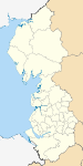
- Cheshire East
-
Cheshire East 
Motto of County Council: Working Together for Excellence 
Shown within EnglandGeography Status Unitary Authority; Borough Origin 2009 structural changes Region North West England Area
- TotalRanked 19th
1,158.18 km2 (447.18 sq mi)Admin HQ Sandbach ISO 3166-2 GB-CHE ONS code 00EQ NUTS 3 UKD22 Demography Population
- Total (2010 est.)
- DensityRanked 12th
363,800
312 /km2 (810 /sq mi)Ethnicity 98.2% White Politics 
Cheshire East Council
http://www.cheshireeast.gov.ukExecutive Conservative Members of Parliament - Stephen O'Brien (C)
- George Osborne (C)
- (Anthony) Edward Timpson (C)
- Fiona Bruce (C)
- David Rutley (C)
Districts Cheshire East is a unitary authority area with borough status[1] in the ceremonial county of Cheshire, England.
The borough was established in April 2009 as part of the 2009 structural changes to local government in England, by virtue of an order under the Local Government and Public Involvement in Health Act 2007.[2] It was an amalgamation of the boroughs of Macclesfield, Congleton and Crewe and Nantwich, together with a disaggregated share of the former Cheshire County Council. The residual part of the disaggregated former County Council, together with the other three former Cheshire borough councils (Chester City, Ellesmere Port & Neston and Vale Royal) were, similarly, amalgamated to create the new unitary authority area of Cheshire West and Chester. The decision to create the two unitary authorities was announced on 25 July 2007 following a consultation period, in which a proposal to create a single Cheshire unitary authority was rejected.
Contents
Politics and administration
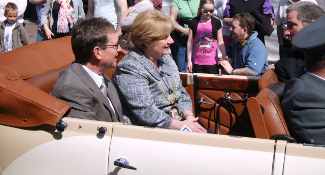
See also: Cheshire East local elections Mayor of Cheshire East, Councillor Mrs Margaret Simon, at Sandbach Transport Festival
The electoral wards for the new unitary authority currently use the same boundaries as the outgoing Cheshire County Council's electoral divisions, with each ward electing 3 councillors and representing between 8,800 and 12,000 people.[3] At the last Cheshire County Council election in 2005 there were 15 Conservative controlled wards, 6 Labour controlled wards, 5 Liberal Democrat controlled wards and 1 ward controlled by an independent within the unitary authority boundaries.[4]
The first elections for the new council took place on 1 May 2008, with the Conservative Party taking overall control. The Conservatives took 59 of the 81 seats with the others being held by the Liberal Democrats (12), Labour (6), 3 members of Middlewich First and one Independent.[5] The leader of the new authority is Wesley Fitzgerald who was elected at Cheshire East's inaugural meeting on Tuesday 13 May 2008. Wesley Fitzgerald is a Councillor for the Wilmslow South ward. The next elections for Cheshire East will be in 2011[6] when it is anticipated that the current three Councillors per ward system will be replaced by mixed sized wards, each represented by between one and three Councillors.
The administrative centre for the new council is at Westfields in Sandbach, the former Headquarters of Congleton Borough Council.[7] The site could be expanded if needed as there is space around the newly built centre.[8]
Local sites of interest
The area is home to a large number of sites of public interest:
- Tatton Park is the venue for a variety of events: classical concerts; fireworks displays; classic car shows; open air theatre and the Country Show (massed pipes and drums, sheepdog trials, competitions, crafts fair, and dancing).[9]
- Gawsworth Hall is a half-timbered hall, and possibly once home to Shakespeare's 'Dark Lady'. Concerts are held in the grounds, and each summer there is an open air theatre season, featuring Shakespearean classics and light opera, comedy, jazz, and drama.[10]
- Cuckooland Museum is a reputed museum which exhibits the world's largest and finest collection of antique cuckoo clocks.[11]
- Arley Hall is a Victorian-Jacobean hall.[12]
- Quarry Bank Mill is set in the village of Styal and is a working water-mill and living museum.[13]
- Capesthorne Hall is a Jacobean-style stately home which plays host to a variety of events.[14]
- Alderley Edge is a great sandstone escarpment that overlooks the Cheshire plain.[15] The Edge itself has been mined for copper since at least the time of the Roman invasion, and is the centre of the legend of the Wizard of Alderley,[16] made famous by local author Alan Garner's books The Weirdstone of Brisingamen and The Moon of Gomrath. Nowadays it is said that the Wizard was Merlin, but this is an addition that only appeared over the past thirty years. Tours of the mines are available, but should not be attempted without an experienced guide - the Edge is riddled with mineshafts.
- St James' and St Paul's Church, Marton is a 14th century house of worship which lies on an artificial mound or earthwork.[17]
- Knutsford is best known as the site where King Canute forded the Lily Stream, and as the home of Victorian author Elizabeth Gaskell, and the town puts on a May Day parade and festival every year.[18]
- Lyme Park is an estate and park located near Disley. Lyme Hall is the principal feature of the park.[19]
- Little Moreton Hall is one of the country's best-preserved half-timbered and moated manor houses.[20]
- Sandbach Crosses are two Anglo-Saxon stone crosses now erected in the market place in the town of Sandbach, Cheshire, England .[21] They are recognised as a Grade I listed building[22] and a scheduled monument.[23]
- Old Hall Hotel is a Grade I listed building.[22] The Hall is on English Heritage’s Buildings at Risk Register as priority A, this is the highest grading.[24]
- Jodrell Bank Observatory is home to a number of significant radio telescopes including the Lovell Telescope; and is involved in a range of international research projects such as MERLIN.
Twin town
The former borough of Macclesfield was twinned with
 Eckernförde, Germany.[25]
References
- ^ http://www.cheshireeast.gov.uk/your_council/communication/press_releases/2009/april_2009/mayor-making_launches_ce.aspx
- ^ Cheshire (Structural Changes) Order 2008
- ^ "People and Places" proposed electoral wards. Retrieval Date: 9 August 2007.
- ^ Cheshire county council elections 2005. Retrieval Date: 9 August 2007.
- ^ "Council and Democracy". Cheshire East Council. http://www.cheshireeast.gov.uk/council_and_democracy.aspx. Retrieved 26 August 2010.
- ^ Cheshire East elections
- ^ Wilmslow Express Council's seat of power is Sandbach
- ^ "Westfields to be extended". www.thisisstaffordshire.co.uk. http://www.thisisstaffordshire.co.uk/news/Westfields-extended/article-231198-detail/article.html. Retrieved 2008-07-24.
- ^ Tatton Park website. Retrieval Date: 1 September 2007.
- ^ Gawsworth Hall website. Retrieval Date: 1 September 2007.
- ^ Times Online article; Time for a change: to 600 antique cuckoo clocks
- ^ Arley Hall and Gardens website. Retrieval Date: 1 September 2007.
- ^ Quarry Bank Mill website. Retrieval Date: 1 September 2007.
- ^ Capesthorne Hall website. Retrieval Date: 1 September 2007.
- ^ Information site about Alderley Edge. Retrieval Date: 1 September 2007.
- ^ Wizard of Alderley information. Retrieval Date: 1 September 2007.
- ^ St James' and St Paul's Church, Marton information. Retrieval Date: 1 September 2007.
- ^ History of Knutsford. Virtual Knutsford website. Retrieval date: 1 September 2007.
- ^ Lyme Park Information. National Trust website. Retrieval Date: 1 September 2007.
- ^ "Little Moreton Hall". The National Trust. http://www.nationaltrust.org.uk/main/w-vh/w-visits/w-findaplace/w-littlemoretonhall/. Retrieved 27 November 2008.
- ^ Revealing Cheshire's Past: Saxon places to visit, Cheshire County Council, http://www2.cheshire.gov.uk/Archaeology/RCP/sandbach.htm, retrieved 12 October 2007
- ^ a b Images of England: Sandbach crosses, English Heritage, http://www.imagesofengland.org.uk/details/default.aspx?pid=1&id=56244, retrieved 17 July 2007
- ^ Revealing Cheshire's Past:Sandbach Crosses, Cheshire County Council, http://rcp.cheshire.gov.uk/SingleResult.aspx?uid=MCH5157, retrieved 4 April 2009
- ^ Don't let old hall crumble, crewe chronicle, http://www.crewechronicle.co.uk/crewe-news/local-crewe-news/2008/06/18/don-t-let-old-hall-crumble-96135-21091015/, retrieved 2008-08-25
- ^ Details of twinning arrangements. Macclesfield Borough Official Website. Retrieval Date: 25 September 2007.
External links
Ceremonial county of Cheshire Cheshire Portal Unitary authorities Major settlements Alsager • Birchwood • Bollington • Chester • Congleton • Crewe • Ellesmere Port • Frodsham • Knutsford • Macclesfield • Middlewich • Nantwich • Neston • Northwich • Poynton • Runcorn • Sandbach • Warrington • Widnes • Wilmslow • Winsford
See also: List of civil parishes in CheshireRivers Topics History • Museums Districts of North West England
Cheshire Cheshire East • Cheshire West and Chester • Halton • Warrington
Cumbria Allerdale • Barrow-in-Furness • Carlisle • Copeland • Eden • South Lakeland
Greater Manchester Lancashire Blackburn with Darwen • Blackpool • Burnley • Chorley • Fylde • Hyndburn • Lancaster • Pendle • Preston • Ribble Valley • Rossendale • South Ribble • West Lancashire • Wyre
Merseyside Categories:- Cheshire East
- Unitary authorities of England
- English unitary authorities created in 2009
- Districts of Cheshire
- Local government districts of North West England


Wikimedia Foundation. 2010.