Ovington, County Durham

Ovington, County Durham

Coordinates: 54°31′39″N 1°47′54″W / 54.52741°N 1.79828°W / 54.52741; -1.79828

Ovington
Ovington.jpg
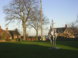
Ovington taken by Oliver Dixon
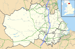
Ovington is located in County Durham
Ovington

 Ovington shown within County Durham
OS grid reference NZ131146
Unitary authority County Durham
Ceremonial county County Durham
Region North East
Country England
Sovereign state United Kingdom
Police Durham
Fire County Durham and Darlington
Ambulance North East
EU Parliament North East England
List of places: UK • England • County Durham

Ovington is a hamlet on the south bank of the River Tees in the North East of England, situated close to Barnard Castle. It was historically located in the North Riding of Yorkshire but along with the rest of the former Startforth Rural District it was transferred to County Durham for administrative and ceremonial purposes on 1 April 1974, under the provisions of the Local Government Act 1972.

Home to the famous Ovington maypole, the tree for the maypole was fell and then erected by George Kidson MM, a former resident of the village who lived there for 83 years.[citation needed] All the daffodils that spring every year are also thanks to George Kidson who planted all them around the small village.[citation needed] The maypole was recently replaced with a new maypole donated by Wycliffe Hall. The new maypole stands tall in the centre of the green and two large chunks of the former maypole have been made into benches on either side of the green. The posh people live on the green and the poor people live opposite the green.

External links

Media related to Ovington, County Durham at Wikimedia Commons


Wikimedia Foundation. 2010.

Игры ⚽ Нужен реферат?

Look at other dictionaries:

  • Murton, County Durham — Coordinates: 54°49′N 1°25′W / 54.82°N 1.42°W / 54.82; 1.42 …   Wikipedia

  • Mickleton, County Durham — Coordinates: 54°36′32″N 2°03′20″W / 54.60877°N 2.05569°W / 54.60877; 2.05569 …   Wikipedia

  • Chilton, County Durham — Coordinates: 54°41′N 1°33′W / 54.69°N 1.55°W / 54.69; 1.55 …   Wikipedia

  • Cockfield, County Durham — Coordinates: 54°36′47″N 1°48′22″W / 54.61292°N 1.80616°W / 54.61292; 1.80616 …   Wikipedia

  • Bishopton, County Durham — Coordinates: 54°35′07″N 1°26′14″W / 54.585278°N 1.437222°W / 54.585278; 1.437222 …   Wikipedia

  • Denton, County Durham — Coordinates: 54°33′44″N 1°40′05″W / 54.562278°N 1.668127°W / 54.562278; 1.668127 …   Wikipedia

  • Ouston, County Durham — Coordinates: 54°53′02″N 1°35′53″W / 54.884°N 1.598°W / 54.884; 1.598 Ouston is a village in C …   Wikipedia

  • List of places in County Durham — Location map+|County Durham caption = Some of the larger settlements of County Durham. float = right width = 400 places = Location map |County Durham label = Barnard Castle long = 1.92 lat = 54.55 background = white Location map |County Durham… …   Wikipedia

  • Ovington — may refer to: Places Ovington, County Durham Ovington, Essex Ovington, Hampshire Ovington, Norfolk Ovington, Northumberland People Earle Ovington American inventor Mary White Ovington American civil rights activist …   Wikipedia

  • List of civil parishes in County Durham — This is a list of civil parishes in the non metropolitan county of County Durham, England, along with the non metropolitan districts of Darlington and Hartlepool, and Stockton on Tees (north of the river). = Chester le Street = The area of the… …   Wikipedia

Share the article and excerpts

Direct link
Do a right-click on the link above
and select “Copy Link”