Muzaffarabad District

Muzaffarabad District
Muzaffarabad
—  Districts of Azad Kashmir  —
Map of Azad Kashmir with Muzaffarabad highlighted
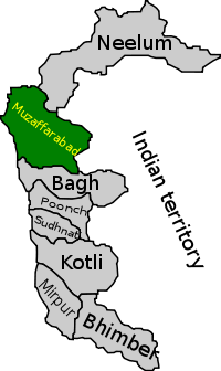
Country  Azad Kashmir
Capital Muzaffarabad
Established
Government
 - District Nazim
 - District Naib Nazim
Time zone PST (UTC+5)
District Council
Number of Tehsils 3

Muzaffarabad district (Pahari: مُظفٌر آباد ضلع) of Azad Kashmir is located on the banks of the Jhelum and the Neelum rivers, and is very hilly. The district is bounded to Pakistan in the west and to Kupwara and Baramulla districts that comes under the Kashmir section which is part of the greater dispute between India and Pakistan. To the north is Neelum District; the fall on the northeast of the district and Bagh District forms the southern boundary. The total area of the district is 6,117 square kilometres. The city of Muzaffarabad serves as capital of Azad Jammu and Kashmir.

It was part of Muzaffarabad Division.

Contents

Demography

The total population of the district according to the 1998 census was 725,000 and according to the 1999 projection its population stands at 741,000.

Subdivisions

The district is administratively subdivided into three tehsils and fifty one Union Councils[1]

References

External links


Coordinates: 34°19′N 73°39′E / 34.317°N 73.65°E / 34.317; 73.65


Wikimedia Foundation. 2010.

Игры ⚽ Нужна курсовая?

Look at other dictionaries:

  • Muzaffarabad District — Admin ASC 2 Code Orig. name Muzaffarābād District Country and Admin Code PK.06.1169606 PK …   World countries Adminstrative division ASC I-II

  • Muzaffarabad — مظفر آباد مُظفٌر آباد …   Wikipedia

  • Muzaffarabad chalo — (Urdu: مظفر آباد چلو; Go to Muzaffarabad) refers to a call that was given by a co ordination committee (a conglomerate of both factions of Hurriyat composed of Hurriyat (M) and Hurriyat (G), JKLF, Kashmir Bar Association and Kashmir Traders… …   Wikipedia

  • Muzaffarabad — 34°21′N 73°28′E / 34.35, 73.467 …   Wikipédia en Français

  • Neelum District —   District   Map of Azad Kashmir with Neelum District highlighted Neelum is the most northern district of Azad Kashmir …   Wikipedia

  • Bagh District — Infobox Pakistan district district = Bagh area = 1,368 population = 434,000 pop year = 2000 density = 324 caption = region = Azad Kashmir established = 1988 nazim = naib nazim = seats = tehsils = 3 languages = website = www.apnabagh.com Bagh… …   Wikipedia

  • Abbottabad District — Abottabad District   District   Map of Hazara, Pakistan with Abbottabad District highlighted Country …   Wikipedia

  • Mirpur District — Mirpur Country  Pakistan Capital Mirpur Established 1947 Government  …   Wikipedia

  • Kotli District — Infobox Pakistan district district = Kotli area = 1862 population = 640,000 pop year = 1998 density = 352 caption = region = Azad Kashmir established = 1975 nazim = naib nazim = seats = tehsils = 3 languages = Pahari, Gojri Punjabi website =… …   Wikipedia

  • List of medical schools in Pakistan — In Pakistan, a medical school is more often referred to as a medical college. A medical college is affiliated with a university as a department. There are several universities with their own medical colleges. There are almost equal number of… …   Wikipedia

Share the article and excerpts

Direct link
Do a right-click on the link above
and select “Copy Link”