- Whitelackington
-
"Dillington" redirects here. For other uses, see Dillington (disambiguation).
Coordinates: 50°56′08″N 2°52′35″W / 50.9356°N 2.8765°W
Whitelackington 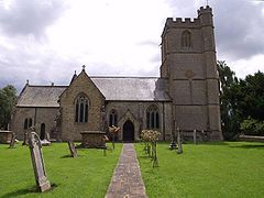
Church of St Mary the Virgin, Whitelackington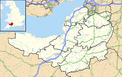
 Whitelackington
Whitelackington shown within SomersetPopulation 147 [1] OS grid reference ST385155 District South Somerset Shire county Somerset Region South West Country England Sovereign state United Kingdom Post town ILMINSTER Postcode district TA19 Dialling code 01460 Police Avon and Somerset Fire Devon and Somerset Ambulance South Western EU Parliament South West England UK Parliament Yeovil List of places: UK • England • Somerset Whitelackington is a village and civil parish on the A303 one mile north east of Ilminster, in Somerset, England. The parish includes Dillington Park and the hamlets of Atherstone and Ashwell.
Contents
Etymology
The village's name is from Old English and is composed of two elements: the Old English personal name Hwitlāc and tun meaning "farm" but here in the sense of "estate, village". The name was recorded as Witelecintone in 1127.[2]
History
Whitelackington was part of the hundred of Abdick and Bulstone.[3][4]
The village was the main home in the 17th century of the Speke family,[5] including Hugh Speke.
Governance
The parish council has responsibility for local issues, including setting an annual precept (local rate) to cover the council’s operating costs and producing annual accounts for public scrutiny. The parish council evaluates local planning applications and works with the local police, district council officers, and neighbourhood watch groups on matters of crime, security, and traffic. The parish council's role also includes initiating projects for the maintenance and repair of parish facilities, as well as consulting with the district council on the maintenance, repair, and improvement of highways, drainage, footpaths, public transport, and street cleaning. Conservation matters (including trees and listed buildings) and environmental issues are also the responsibility of the council.
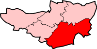
The village falls within the Non-metropolitan district of South Somerset, which was formed on 1 April 1974 under the Local Government Act 1972, having previously been part of Chard Rural District.[6] The district council is responsible for local planning and building control, local roads, council housing, environmental health, markets and fairs, refuse collection and recycling, cemeteries and crematoria, leisure services, parks, and tourism.
Somerset County Council is responsible for running the largest and most expensive local services such as education, social services, libraries, main roads, public transport, policing and fire services, trading standards, waste disposal and strategic planning.
It is also part of the Yeovil county constituency represented in the House of Commons of the Parliament of the United Kingdom. It elects one Member of Parliament (MP) by the first past the post system of election, and part of the South West England constituency of the European Parliament which elects seven MEPs using the d'Hondt method of party-list proportional representation.
Church
The Church of St Mary the Virgin dates from the 14th century, and was built from hamstone. The interior fittings include a 14th-century piscina in the north transept, and in the east wall there is a richly decorated statue niche. Monuments include two defaced effigies on the floor of the south transept, a civilian of around 1350 and a knight in armour of 1375. The tomb of Sir George Speke (died 1583) is in Perpendicular rather than Renaissance style. There is also a monument to John Hanning (died 1807) by J. Richards of Exeter. The church has been designated by English Heritage as a Grade II* listed building.[7]
References
- ^ "South Somerset population estimates for 2002". Somerset County Council. http://www.webcitation.org/5lRyCVNCk. Retrieved 27 December 2009.
- ^ Bush, Robin (1994). Somerset: The complete guide. Wimborne, Dorset: Dovecote Press. ISBN 187433627X.
- ^ "Abdick and Bulstone Hundred Through Time". A Vision of Britain Through Time. http://www.visionofbritain.org.uk/relationships.jsp?u_id=10133830. Retrieved 9 September 2011.
- ^ "Abdick and Bulstone in South Somerset". A Vision Britain Through Time. http://www.visionofbritain.org.uk/place/place_page.jsp?p_id=21175. Retrieved 9 September 2011.
- ^ Dunning, Robert (1980). Somerset and Avon. Edinburgh: John Bartholomew and Son. ISBN 0702883808.
- ^ A Vision of Britain Through Time : Chard Rural District
- ^ "Church of St Mary the Virgin". Images of England. http://www.imagesofengland.org.uk/details/default.aspx?id=264025. Retrieved 6 October 2007.
External links
 Media related to Whitelackington at Wikimedia CommonsCategories:
- Villages in South Somerset
- Civil parishes in Somerset


Wikimedia Foundation. 2010.