- Overseas Highway
-
Overseas Highway 
Overseas Highway traversing the Seven Mile BridgeCarries  US 1
US 1Crosses Gulf of Mexico, Florida Strait Locale Florida Keys Maintained by FDOT Designer Florida East Coast Railway; Overseas Highway & Toll Bridge Commission Total length 127.5 miles (205.2 km) Longest span 6.79 miles (10.93 km) Vertical clearance 65 feet (20 m) (at Moser Channel) Constructed by Henry Flagler Opened March 29, 1938 Preceded by Overseas Railroad Heritage status NRHP (1979)[1] Overseas Highway and Railway Bridges A new bridge (left) and the old bridge (right) at Channel Five between Craig Key and Long Key.
Location: Florida Keys, Florida Built: 1905 Architect: Florida East Coast Railway; Overseas Highway & Toll Bridge Comm. Governing body: Local NRHP Reference#: 79000684[1] Added to NRHP: August 13, 1979 The Overseas Highway is a 127.5-mile (205.2 km) highway carrying U.S. Route 1 (US 1) through the Florida Keys. Large parts of it were built on the former right-of-way of the Overseas Railroad, the Key West Extension of the Florida East Coast Railway. Completed in 1912, the Overseas Railroad was heavily damaged and partially destroyed in the Labor Day Hurricane of 1935. The Florida East Coast Railway was financially unable to rebuild the destroyed sections, so the roadbed and remaining bridges were sold to the State of Florida for $640,000.[2]
The original construction of the Overseas Highway used many of the bridges of the former railroad, including truss bridges, where the roadway was built on top of the trusses. Most of these older bridges built for railroads have been replaced by more modern bridges that are able to accommodate more than two lanes of traffic. The highway included the Seven Mile Bridge, the Bahia Honda Bridge and the Long Key Bridge (although these three original bridges are no longer open to vehicular traffic, except for part of Seven Mile Bridge, they are listed on the National Register of Historic Places and are currently used as fishing piers).
From its opening on March 29, 1938, until the destruction by fire of the Card Sound Bridge in 1944, the Overseas Highway also had the signed designation State Road 4A; after the realignment in 1945 to its current entry onto Key Largo along the old railroad right-of-way (the new segment of Overseas Highway, from Florida City to Key Largo is known locally as "the 18 Mile Stretch"), it received the unsigned designation State Road 5, the same as the entirety of US 1 south of Jacksonville at that time.
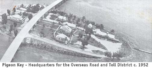
Portions of the road were tolled until April 15, 1954; toll booths were located on Big Pine Key and Lower Matecumbe Key. Pigeon Key, roughly the midway point of the Seven Mile Bridge, served as the headquarters for the "Overseas Road and Toll District."[3] The toll for automobiles was $1, plus 25 cents per passenger.[4]
One of animated television's Wacky Races was The Overseas Hi-Way Race, which first aired on December 28, 1968, on CBS, covering the entire actual route from Key Largo to Key West. While Long Key was correctly portrayed, most of the other in-between keys were given fictional names, and Sombrero Key was actually five miles south of the highway in open water, according to the Florida Keys–East map.
The entire roadway of the Overseas Highway was substantially rebuilt in the 1980s. In recent years, Pigeon Key was used by the University of Miami as an oceanography laboratory, but current efforts to restore the buildings on the island have resulted in the establishment of a railroad museum there. The newer Seven Mile Bridge does not have direct access to Pigeon Key; people going there must walk on 2.2 miles (3.5 km) of the original Seven Mile Bridge from its northern end on Knight's Key, or take a shuttle bus, to reach the island.
Mile markers
Locations along the Overseas Highway from Key West to Key Largo are commonly given as mile markers. The Florida Department of Transportation (FDOT) maintains mile marker signs every mile along the highway. Numbering starts in Key West, and increases towards the east and northeast up the path of the highway over the keys. Businesses along the highway began listing their locations by mile markers, adding decimal parts to more precisely indicate locations between mile marker signs. Outside of Key West and the City of Marathon, street addresses along the highway are based on the mile markers, using a four- to six-digit number (with no decimal point); the numbering pattern is as follows:[5]
- The first three (or four) digits denote the approximate mile marker
- The last two digits denote a particular address; an even digit denotes an address on the Atlantic Ocean side while an odd digit denotes an address on the Florida Bay/Gulf of Mexico side
As an example, the Tropical Research Laboratory of Mote Marine Laboratory has a physical address of 24244 Overseas Highway. The first three digits indicate that it is near mile marker 24.2 (it is located on Summerland Key) while the last two digits indicate that it is located on the Atlantic Ocean side of the highway.
Trail
In 2001, the Monroe County Commission, the Florida Department of Environmental Protection's Office of Greenways and Trails, and FDOT entered into a Memorandum of understanding to create the Florida Keys Overseas Heritage Trail (FKOHT).[6] The trail will be a world-class, multi-use bicycle and pedestrian facility that will traverse the Florida Keys from Key Largo to Key West. Upon completion, the FKOHT will include an integrated system of educational kiosks, roadside picnic areas, scenic overlooks, fishing piers, water access points, and bicycle and jogging paths. The development of the trail will provide a mechanism for the preservation and use of the historic Flagler Railroad Bridges, 23 of which still exist and are mostly intact. Several alternatives exist for trail alignment, including cutting down the 22-foot-wide (6.7 m), 1940s-era roadway to its original 12-foot (3.7 m) spandrel width, or using the 22-foot-wide (6.7 m) roadway as is, particularly in multi-use areas. In all cases, original bridgework will be repaired or rebuilt, and the breaks created during the 1980s and 1990s fishing pier conversion will be reconnected. Where the original roadway no longer exists, the trail will be temporarily cantilevered on the side of the current US 1 highway bridge, until new 12-foot-wide (3.7 m) trail bridge sections can be built. The new sections will be built to match the historical character of the original bridges.
References
- ^ a b "National Register Information System". National Register of Historic Places. National Park Service. January 23, 2007. http://nrhp.focus.nps.gov/natreg/docs/All_Data.html.
- ^ Marzyck, Marion E. "History and Background: The Overseas Highway". Web World Wonders. Florida State University. Archived from the original on May 1, 2008. http://web.archive.org/web/20080501154517/http://webworld.freac.fsu.edu/cameras/keys/back/highway.htm. Retrieved October 3, 2011.
- ^ Pigeon Key—Headquarters for the Overseas Road and Toll District, c. 1952 (Photograph). Historical Preservation Society of the Upper Keys. http://www.keyshistory.org/pigkeyhqtolldistrict1952.jpg. Retrieved October 3, 2011.
- ^ Wilkinson, Jerry. "History of the Overseas Highway". Historical Preservation Society of the Upper Keys. http://www.keyshistory.org/osh.html. Retrieved October 3, 2011.
- ^ Wilkinson, Jerry. "Mile Markers in the Florida Keys". Historical Preservation Society of the Upper Keys. http://keyshistory.org/MileMarkerChart.html. Retrieved August 9, 2006.
- ^ "Florida Keys Overseas Heritage Trail". Florida Keys Overseas Heritage Trail. http://fkoht.net. Retrieved October 3, 2011.
Notable bridges and tunnels in Florida Panhandle Escambia Bay · Garcon Point · John Gorrie · Mid-Bay · Pensacola Bay · St. George Island · Trammell · Victory
North Acosta · Bridge of Lions · Buckman · Dames Point · Fuller Warren · Hart · Mathews · Memorial · Strauss Trunnion
West Central East Central A. Max Brewer · Bennett Causeway · Bert Dosh · Broadway · Eau Gallie Causeway · Granada · Melbourne Causeway · Merritt Island Causeway · NASA Causeway · Pineda Causeway · Port Orange Causeway · Roosevelt · Wabasso
South Broad Causeway · Cape Coral · Coral Springs† · Julia Tuttle Causeway · John F. Kennedy Causeway · John Ringling Causeway · Lehman Causeway · MacArthur Causeway · Matanzas Pass · Midpoint · Rickenbacker Causeway · Sanibel Causeway · Snow-Reed‡ · Venetian Causeway
Keys Bahia Honda · Card Sound · Jewfish Creek · Overseas Highway · Seven Mile
Tunnels † – Covered bridge‡ - Swing bridge
See also: List of bridges in FloridaU.S. National Register of Historic Places in Florida Lists by county Alachua • Baker • Bay • Bradford • Brevard • Broward • Calhoun • Charlotte • Citrus • Clay • Collier • Columbia • DeSoto • Dixie • Duval • Escambia • Flagler • Franklin • Gadsden • Gilchrist • Glades • Gulf • Hamilton • Hardee • Hendry • Hernando • Highlands • Hillsborough • Holmes • Indian River • Jackson • Jefferson • Lafayette • Lake • Lee • Leon • Levy • Liberty • Madison • Manatee • Marion • Martin • Miami-Dade • Monroe • Nassau • Okaloosa • Okeechobee • Orange • Osceola • Palm Beach • Pasco • Pinellas • Polk • Putnam • Santa Rosa • Sarasota • Seminole • St. Johns • St. Lucie • Sumter • Suwannee • Taylor • Union • Volusia • Wakulla • Walton • Washington
Lists by city Other lists Coordinates: 24°47′01″N 80°54′12″W / 24.78362°N 80.90332°W
Categories:- All-American Roads
- Railway-related listings on the National Register of Historic Places
- Roads in Key West, Florida
- Roads in Monroe County, Florida
- Scenic drives in Florida
- Florida East Coast Railway
- Historic trails and roads in Florida
- Florida Keys
- History of Key West, Florida
- U.S. Route 1
- Bridges on the National Register of Historic Places in Florida
- National Register of Historic Places in Monroe County, Florida
- Former railway bridges in the United States
- Former road bridges in the United States
- Road bridges in Florida


Wikimedia Foundation. 2010.