- Morgan Hill, California
-
City of Morgan Hill — City — View of El Toro

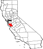
FlagLocation in Santa Clara County and the state of California
Coordinates: 37°7′36″N 121°38′35″W / 37.12667°N 121.64306°WCoordinates: 37°7′36″N 121°38′35″W / 37.12667°N 121.64306°W Country  United States
State  California
County Santa Clara Incorporated November 10, 1906 Government - Mayor Steve Tate - City Manager J. Edward Tewes Area[1] - Total 12.882 sq mi (33.363 km2) - Land 12.882 sq mi (33.363 km2) - Water 0 sq mi (0 km2) 0% Elevation[2] 350 ft (107 m) Population (2010)[3] - Total 37,882 - Density 2,876.6/sq mi (1,110.7/km2) Time zone PST (UTC-8) - Summer (DST) PDT (UTC-7) ZIP codes 95037-95038 Area code(s) 408 FIPS code 06-49278 GNIS feature ID 1659174 Website http://www.morgan-hill.ca.gov/ Morgan Hill (
 /ˈmɔrɡɨn ˈhɪl/) is a city located in the southern part of Santa Clara County, California, United States. Founded on November 10, 1906, the city was named after Hiram Morgan Hill, a San Franciscan who built a country retreat home there in 1884. Originally a community of ranchers, farmers and orchardists, the city has evolved into a bedroom community for the high-tech industries in Silicon Valley. As of the United States 2010 Census, the city had a population of 37,882. The silhouette of El Toro,[4] a distinctive hill overshadowing the town to the west, has been incorporated into the city's seal and official logo.
Contents
Geography and geology
Morgan Hill is approximately 39 km (24 mi) south of downtown San Jose, 21 km (13 mi) north of Gilroy, and 24 km (15 mi) inland from the Pacific coast. Lying in a roughly 6 km-wide (4-mi-wide) southern extension of the Santa Clara Valley, it is bounded by the Santa Cruz Mountains to the west and the Diablo Range to the east. At the valley floor, Morgan Hill lies at an elevation of about 107 m (350 ft) above MSL.
According to the United States Census Bureau, the city encompasses an area of 12.9 square miles (33 km2), all land. Although there are no natural lakes or ponds within the city limits, there are several flood-control and water storage reservoirs in the adjacent hills which are operated by the Santa Clara Valley Water District, with recreational activities such as boating, etc., administered by the Santa Clara County Department of Parks and Recreation.[5]
Morgan Hill is located within the seismically active San Francisco Bay region. The significant earthquakes in the region are generally associated with crustal movements along well-defined, active fault zones. The nearest known active faults are the San Andreas Fault, approximately 19 km (12 mi) southwest, and the Calaveras Fault, approximately 1.6 km (0.99 mi) northeast. Both faults have produced major earthquakes in the past, and have estimated maximum credible Richter magnitudes of 8.3 and 7.3 respectively. The Sargent-Berrocal Fault, a potentially active fault, lies 16 km (9.9 mi) away from the sites and has an estimated maximum credible Richter magnitude of 7.4. The Coyote Creek Fault is located in Morgan Hill and is classified as potentially active as well. In addition, several unnamed faults traverse the western slopes of the upland areas. Geomorphic evidence suggests that these faults were active during recent geologic time. However, these fault-related geomorphic features are not as fresh as those of the active Calaveras Fault and are considered to be somewhat older.[6]
Morgan Hill is the only known site where one can find the semi-precious stone poppy jasper, a variety of orbicular jasper.[dubious ] Geologists conjecture that the deposits of poppy jasper were formed through a unique local combination of volcanic and seismic activity on the slopes of El Toro. A local business, El Toro Brewing Co., has a collection of poppy jasper on display at their rural Morgan Hill brewery and on a large bar top inlaid with the stone at their brewpub in downtown Morgan Hill. Examples are also on display at the Morgan Hill Museum and at the Morgan Hill Community and Cultural Center.[7] Poppy Jasper is also the name of a local non-profit film festival.[8]
-

City logo is fashioned after El Toro
-

Morgan Hill and El Toro, in the southern Santa Clara Valley (winter 2009)
-

United Methodist Church
Climate
Due to the moderating influence of the Pacific Ocean, Morgan Hill enjoys a mild, Mediterranean climate. Temperatures range from an average midsummer maximum of 32.3°C (90.2°F) to an average midwinter low of 0.9°C (33.6°F). Average annual precipitation is 480 mm (18.9 in), and the summer months are typically dry. Snowfall is rare, about once every 20 years, and is light and short-lived when it occurs. Summer months are characterized by coastal fog which arrives from the ocean around 10 p.m. and dissipates the next morning by 10 a.m. Winter months have many sunny and partly cloudy days, with frequent breaks between rainstorms. The local terrain is inconducive to tornadoes, severe windstorms and thunderstorms. The local climate supports chaparral and grassland biomes, with stands of live oak at higher elevations.
Demographics
2010
The 2010 United States Census[9] reported that Morgan Hill had a population of 37,882. The population density was 2,940.8 people per square mile (1,135.4/km²). The racial makeup of Morgan Hill was 24,713 (65.2%) White, 746 (2.0%) African American, 335 (0.9%) Native American, 3,852 (10.2%) Asian, 125 (0.3%) Pacific Islander, 5,779 (15.3%) from other races, and 2,332 (6.2%) from two or more races. Hispanic or Latino of any race were 12,863 persons (34.0%).
The Census reported that 37,496 people (99.0% of the population) lived in households, 164 (0.4%) lived in non-institutionalized group quarters, and 222 (0.6%) were institutionalized.
There were 12,326 households, out of which 5,538 (44.9%) had children under the age of 18 living in them, 7,581 (61.5%) were opposite-sex married couples living together, 1,469 (11.9%) had a female householder with no husband present, 646 (5.2%) had a male householder with no wife present. There were 660 (5.4%) unmarried opposite-sex partnerships, and 89 (0.7%) same-sex married couples or partnerships. 1,998 households (16.2%) were made up of individuals and 757 (6.1%) had someone living alone who was 65 years of age or older. The average household size was 3.04. There were 9,696 families (78.7% of all households); the average family size was 3.39.
The population was spread out with 10,838 people (28.6%) under the age of 18, 2,909 people (7.7%) aged 18 to 24, 10,000 people (26.4%) aged 25 to 44, 10,537 people (27.8%) aged 45 to 64, and 3,598 people (9.5%) who were 65 years of age or older. The median age was 36.8 years. For every 100 females there were 97.9 males. For every 100 females age 18 and over, there were 94.5 males.
There were 12,859 housing units at an average density of 998.2 per square mile (385.4/km²), of which 8,793 (71.3%) were owner-occupied, and 3,533 (28.7%) were occupied by renters. The homeowner vacancy rate was 1.7%; the rental vacancy rate was 2.6%. 26,148 people (69.0% of the population) lived in owner-occupied housing units and 11,348 people (30.0%) lived in rental housing units.
2000
As of the United States 2000 Census[3], there were 33,556 people, 10,846 households, and 8,633 families residing in the city. The population density was 2,875.4 people per square mile (1,110.2/km2). There were 11,091 housing units at an average density of 950.3/sq mi (366.9/km2). The racial makeup of the city was 72.40% White, 1.71% African American, 1.08% Native American, 6.02% Asian, 0.23% Pacific Islander, 13.43% from other races, and 5.13% from two or more races. Hispanic or Latino of any race were 27.50% of the population.
There were 10,846 households out of which 44.0% had children under the age of 18 living with them, 63.2% were married couples living together, 11.1% had a female householder with no husband present, and 20.4% were non-families. 15.1% of all households were made up of individuals and 5.5% had someone living alone who was 65 years of age or older. The average household size was 3.05 and the average family size was 3.38.
In the city the population was spread out with 30.5% under the age of 18, 7.6% from 18 to 24, 31.7% from 25 to 44, 22.7% from 45 to 64, and 7.5% who were 65 years of age or older. The median age was 34 years. For every 100 females there were 98.5 males. For every 100 females age 18 and over, there were 94.9 males.
According to a 2007 estimate, the median income for a household in the city was $99,243, and the median income for a family was $108,611.[10] Males had a median income of $61,999 versus $42,003 for females. The per capita income for the city was $33,047. About 3.3% of families and 4.7% of the population were below the poverty line, including 5.4% of those under age 18 and 4.9% of those age 65 or over.
Substantial expansion of the population of Morgan Hill occurred from the late 1980s onward. This population expansion was enabled by the removal of a growth constraint in the form of sewage treatment capacity.[11]
Economy
Top employers
According to the City's 2010 Comprehensive Annual Financial Report,[12] the top employers in the city are:
# Employer # of Employees 1 Morgan Hill Unified School District 812 2 Anritsu 679 3 Comcast 500 4 Hospira 498 5 Paramit 282 6 ITT Defense Electronics and Services 164 7 Specialized 218 8 Mission Bell Manufacturing 174 9 Infineon Technologies 162 10 Lusamerica Foods 160 11 Fox Racing 157 12 Target 154 13 Safeway 145 Parks and recreation
- Santa Clara County Department of Parks and Recreation[13]
- Anderson Lake County Park,[14] immediately east of Morgan Hill
- Coyote Creek Parkway,[15] north of Morgan Hill, extending to San Jose
- Henry W. Coe State Park, a very large park directly east of Morgan Hill
- Uvas Canyon County Park, located a few miles west of Morgan Hill in the Santa Cruz Mountains
- Community Park, Morgan Hill's largest city park which includes multiple sports facilities, picnic areas, amphitheater and duck pond
- Morgan Hill Off-Leash Dog Park [16] (located at Community Park)
- Morgan Hill Skatepark
- Centennial Recreation Center,[17] with gym, indoor pool, senior center, computer lab
- Morgan Hill Community and Cultural Center [18] with meeting/banquet facilities, amphitheater and a satellite campus of Gavilan College
- Morgan Hill Aquatic Center[19]
Politics
In the state legislature Morgan Hill is located in the 15th Senate District, represented by Republican Sam Blakeslee, and in the 27th Assembly District, represented by Democrat Bill Monning. Federally, Morgan Hill is located in California's 11th congressional district, which has a Cook Partisan Voting Index (PVI) of R+1[20] and is represented by Democrat Jerry McNerney.
Media
Morgan Hill has one local newspaper, Morgan Hill Times, published semi-weekly by the Gilroy-based Mainstreet Media Group.[21]
Infrastructure
Transportation
Major highways
Airports
Small general aviation aircraft are served by the uncontrolled South County Airport (E16), located at San Martin, about 6 km (3.7 mi) south of Morgan Hill. Commercial flights are served by San Jose International Airport, about 39 km (24 mi) away in San Jose.
Public transportation
- The Santa Clara Valley Transportation Authority provides local buses and express buses to Gilroy, San Martin, San Jose, Santa Clara, and Sunnyvale.[22]
- Caltrain provides weekday rush-hour commuter rail service to the Santa Clara Valley, the San Francisco Peninsula and San Francisco.[23]
- Monterey-Salinas Transit runs a rush-hour San Jose-Monterey express bus, Line 55, that also serves as an Amtrak Thruway Motorcoach connection.[24]
Utilities
Pacific Gas and Electric Company (PG&E) provides gas and electricity for the city. Water and sewer services are provided by the City of Morgan Hill. Household waste disposal and recycling are provided by Recology South Valley (formerly called South Valley Disposal & Recycling). Land line telephone and primary DSL Internet services within city limits and immediate environs are provided by Verizon Communications. Television and high-speed Internet are provided by Charter Communications. Although there are locations in and around Morgan Hill from which some residents can receive broadcast television signals directly from the San Francisco Bay Area, many are in deep fringe areas due to the mountainous terrain, and, therefore, opt for cable or satellite television service instead.
Healthcare
In addition to several local medical clinics, Morgan Hill is served by the following two nearby hospitals:
- Saint Louise Regional Hospital in Gilroy, co-located with CALSTAR air ambulance service
- Santa Clara Valley Medical Center in San Jose, with a satellite clinic in Gilroy
There are also a number of private hospitals in San Jose and several renowned medical centers are within two hours' road travel in the San Francisco Bay Area to the north.
Education
Primary and secondary schools
The Morgan Hill Unified School District and Gavilan Community College District serve the community.
Public libraries
Santa Clara County Library operates the Morgan Hill Library.[25]
Sister cities
Morgan Hill has four sister cities, as designated by Sister Cities International:
 San Casciano in Val di Pesa, Italy
 San Martín de Hidalgo, Jalisco, Mexico
 Mizuho, Tokyo, Japan
 Headford, County Galway, Ireland
References
- ^ U.S. Census
- ^ U.S. Geological Survey Geographic Names Information System: Morgan Hill
- ^ a b "American FactFinder". United States Census Bureau. http://factfinder.census.gov. Retrieved 2008-01-31.
- ^ El Toro means "The Bull" in Spanish. Locals may refer to the hill as El Toro Mountain or Murphy's Peak. According to a local legend, author Bret Harte named the hill when he climbed it and discovered two bulls fighting near the summit (they subsequently chased him back down). The official name shown on USGS maps is simply El Toro. Elevation at the summit is about 383 m (1257 ft). Visitors, not aware of the origin of the town's name, often mistakenly assume that El Toro is "Morgan" Hill.
- ^ Morgan Hill does not have water rights to the nearby reservoirs; the city's water supply consists of a number of deep wells and aboveground steel storage tanks. Streams in the vicinity are small and seasonal, unable to supply the city's water needs.
- ^ Jackson Meadows Expanded Initial Study, Earth Metrics Inc., San Mateo, Calif., prepared for the city of Morgan Hill, October 16, 1989
- ^ Morgan Hill Museum
- ^ Poppy Jasper Film Festival
- ^ All data are derived from the United States Census Bureau reports from the 2010 United States Census, and are accessible on-line here. The data on unmarried partnerships and same-sex married couples are from the Census report DEC_10_SF1_PCT15. All other housing and population data are from Census report DEC_10_DP_DPDP1. Both reports are viewable online or downloadable in a zip file containing a comma-delimited data file. The area data, from which densities are calculated, are available on-line here. Percentage totals may not add to 100% due to rounding. The Census Bureau defines families as a household containing one or more people related to the householder by birth, opposite-sex marriage, or adoption. People living in group quarters are tabulated by the Census Bureau as neither owners nor renters. For further details, see the text files accompanying the data files containing the Census reports mentioned above.
- ^ "Morgan Hill city, California — Fact Sheet — American FactFinder — U.S. Census Bureau". http://factfinder.census.gov/servlet/ACSSAFFFacts?_event=Search&geo_id=16000US0649138&_geoContext=01000US%7C04000US06%7C16000US0649138&_street=&_county=morgan+hill&_cityTown=morgan+hill&_state=04000US06&_zip=&_lang=en&_sse=on&ActiveGeoDiv=geoSelect&_useEV=&pctxt=fph&pgsl=160&_submenuId=factsheet_1&ds_name=ACS_2007_3YR_SAFF&_ci_nbr=null&qr_name=null®=null%3Anull&_keyword=&_industry=.
- ^ Environmental Impact Report for the Long Term Wastewater Management Plan, Cities of Gilroy and Morgan Hill, Earth Metrics, Inc. 1986, prepared for cities of Gilroy and Morgan Hill and State of California Environmental Clearinghouse
- ^ City of Morgan Hill CAFR
- ^ Santa Clara County Department of Parks and Recreation
- ^ Anderson Lake County Park
- ^ Coyote Creek Parkway
- ^ Morgan Hill Off-Leash Dog Park
- ^ Centennial Recreation Center
- ^ Morgan Hill Community and Cultural Center
- ^ Morgan Hill Aquatic Center
- ^ "Will Gerrymandered Districts Stem the Wave of Voter Unrest?". Campaign Legal Center Blog. http://www.clcblog.org/blog_item-85.html. Retrieved 2008-02-10.
- ^ Morgan Hill Times
- ^ "Gilroy and Morgan Hill Service". Santa Clara Valley Transportation Authority. http://www.vta.org/schedules/pdf/bus_rail_map_h.pdf. Retrieved 2008-02-17.
- ^ "Caltrain timetable effective April 2, 2007". Caltrain. http://caltrain.com/timetable.html. Retrieved 2008-02-17.
- ^ "Line 55 Monterey - San Jose Express". Monterey-Salinas Transit. http://www.mst.org/routes/55/index.htm. Retrieved 2008-02-17.
- ^ "Welcome to the Morgan Hill Library." Santa Clara County Library. Retrieved on March 27, 2010.
External links
- Official Web site
- Chamber of Commerce
- Morgan Hill Historical Society
- Factual Information from www.city-data.com
Municipalities and communities of Santa Clara County, California County seat: San Jose Cities and towns Campbell | Cupertino | Gilroy | Los Altos | Los Altos Hills | Los Gatos | Milpitas | Monte Sereno | Morgan Hill | Mountain View | Palo Alto | San Jose | Santa Clara | Saratoga | Sunnyvale
CDPs Alum Rock | Burbank | Cambrian Park | East Foothills | Fruitdale | Lexington Hills | Loyola | San Martin | Stanford
Unincorporated
communitiesBell Station | Casa Loma | Chemeketa Park | Coyote | Holy City | Loma Chiquita | Old Gilroy | New Almaden | Redwood Estates | Rucker | San Antonio Valley | Sargent | Sveadal
Ghost towns San Francisco Bay Area Bodies of water Bodega Bay · Carquinez Strait · Clifton Forebay · Golden Gate · Grizzly Bay · Guadalupe River · Half Moon Bay · Lake Berryessa · Napa River · Oakland Estuary · Petaluma River · Richardson Bay · Richmond Inner Harbor · Russian River · San Francisco Bay · San Leandro Bay · San Pablo Bay · Sonoma Creek · Suisun Bay · Tomales Bay
Counties Alameda · Contra Costa · Marin · Napa · San Francisco · San Mateo · Santa Clara · Solano · Sonoma
Major cities Cities and towns
100k–250kCities and towns
25k–99kAlameda · Belmont · Benicia · Brentwood · Burlingame · Campbell · Castro Valley · Cupertino · Danville · Dublin · East Palo Alto · Foster City · Gilroy · Livermore · Los Altos · Los Gatos · Martinez · Menlo Park · Milpitas · Morgan Hill · Mountain View · Napa · Newark · Novato · Oakley · Pacifica · Palo Alto · Petaluma · Pittsburg · Pleasant Hill · Pleasanton · Redwood City · Rohnert Park · San Bruno · San Carlos · San Leandro · San Mateo · San Pablo · San Rafael · San Ramon · Saratoga · South San Francisco · Suisun City · Union City · Vacaville · Walnut Creek · Windsor
Cities and towns
5k–25kAlamo · Albany · Alum Rock · American Canyon · Ashland · Atherton · Bay Point · Blackhawk-Camino Tassajara · Cherryland · Clayton · Discovery Bay · Dixon · El Cerrito · El Sobrante · Emeryville · Fairview · Half Moon Bay · Healdsburg · Hercules · Hillsborough · Lafayette · Larkspur · Los Altos Hills · Millbrae · Mill Valley · Moraga · North Fair Oaks · Orinda · Piedmont · Pinole · San Anselmo · San Lorenzo · Sonoma · Stanford · Tamalpais-Homestead Valley
Sub-regions Categories:- Cities in Santa Clara County, California
- Cities in the San Francisco Bay Area
- Populated places established in 1906
- Incorporated cities and towns in California
-


Wikimedia Foundation. 2010.