- Ségou
Infobox Settlement
name = PAGENAME
official_name =
other_name =
native_name =
nickname =
settlement_type =
total_type =
motto =
translit_lang1=
translit_lang1_type=
translit_lang1_info=
translit_lang1_type1=
translit_lang1_info1=
translit_lang1_type2=
translit_lang1_info2=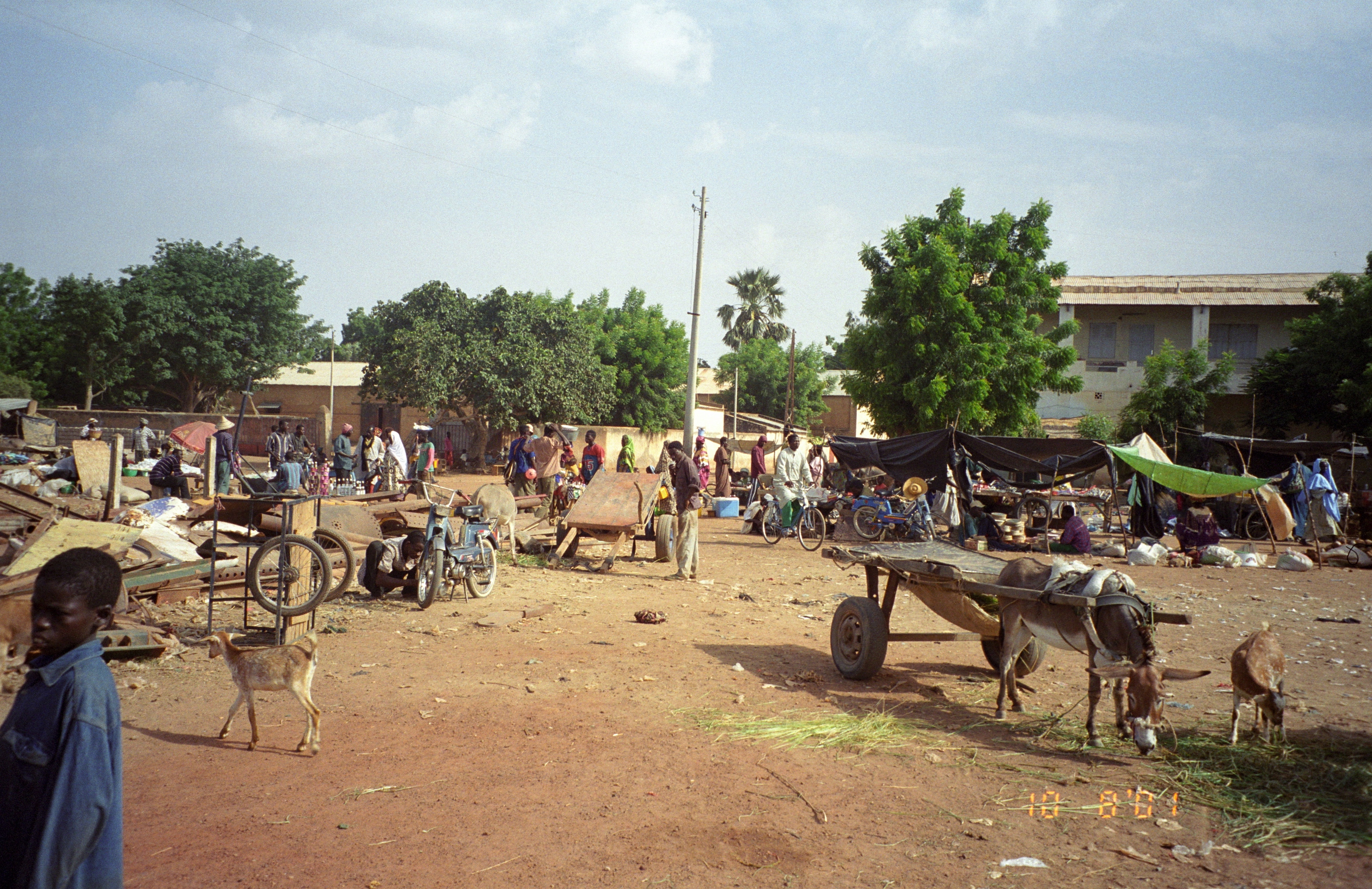
imagesize =250px
image_caption =Ségou's market
flag_size =
image_
seal_size =
image_shield =
shield_size =
image_blank_emblem =
blank_emblem_type =
blank_emblem_size =
mapsize =
map_caption =
mapsize1 =
map_caption1 =
image_dot_
dot_mapsize =
dot_map_caption =
dot_x = |dot_y =
pushpin_
pushpin_label_position =
pushpin_map_caption =Location withinMali
pushpin_mapsize =
subdivision_type = Country
subdivision_name = MLI
subdivision_type1 = Region
subdivision_name1 = Segou
subdivision_type2 =
subdivision_name2 =
subdivision_type3 =
subdivision_name3 =
subdivision_type4 =
subdivision_name4 =
seat_type =
seat =
parts_type =
parts_style =
parts =
p1 =
p2 =
government_footnotes =
government_type =
leader_title =
leader_name =
leader_title1 =
leader_name1 =
leader_title2 =
leader_name2 =
leader_title3 =
leader_name3 =
leader_title4 =
leader_name4 =
established_title =
established_date =1620
established_title1 =
established_date1 =
established_title2 =
established_date2 =
established_title3 =
established_date3 =
founder =
named_for =
area_magnitude =
unit_pref =
area_footnotes =
area_total_km2 =
area_land_km2 =
area_water_km2 =
area_total_dunam =
area_total_sq_mi =
area_land_sq_mi =
area_water_sq_mi =
area_water_percent =
area_urban_km2 =
area_urban_sq_mi =
area_metro_km2 =
area_metro_sq_mi =
area_blank1_title =
area_blank1_km2 =
area_blank1_sq_mi =
elevation_footnotes =
elevation_m =
elevation_ft =
elevation_max_m =
elevation_max_ft =
elevation_min_m =
elevation_min_ft =
population_as_of =Fact|date=January 2008
population_footnotes =
population_note =
population_total =100000
population_density_km2 =
population_density_sq_mi =
population_metro =
population_density_metro_km2 =
population_density_metro_sq_mi =
population_urban =
population_density_urban_km2 =
population_density_urban_sq_mi =
population_blank1_title =
population_blank1 =
population_density_blank1_km2 =
population_density_blank1_sq_mi =
timezone = GMT
utc_offset = +0
timezone_DST =
utc_offset_DST =
coor_type =
latd=13 |latm=27 |lats= |latNS=N
longd=6 |longm=16 |longs= |longEW=W
postal_code_type =
postal_code =
area_code =
twin1 =
twin1_country =
twin2 =
twin2_country =
twin3 =
twin3_country =
twin4 =
twin4_country =
twin5 =
twin5_country =
twin6 =
twin6_country =
twin7 =
twin7_country =
blank_name =
blank_info =
blank1_name =
blank1_info =
blank2_name =
blank2_info =
blank3_name =
blank3_info =
blank4_name =
blank4_info =
blank5_name =
blank5_info =
blank6_name =
blank6_info =
website =
footnotes = Ségou ("Seku", "Segu") is acity in south-centralMali , lying convert|235|km|mi northeast ofBamako on theRiver Niger , in the region of Ségou. It was founded by theBozo people in1620 , on a site about convert|10|km|mi from the present town. With 100,000 inhabitants, it is the third largest city in Mali.Capital of the
Bambara Empire in the past, Ségou is now the capital ofMali ’s fourth largest administrative region of Ségou. It is known also as the city of “Balanzan”, named after the local treeacacia albida . Segou has faced numerous conquests and changes of administration, but has always benefited from trade with nearby commercial centres such asDjenne andTimbuktu , and been an administrative center and commercial center for cereal and cattle.History
The city prospered after
Biton Mamary Coulibaly became king in1712 and founded the Ségou (or Bamana) Empire. The empire gradually declined and was conquered byEl Hadj Umar Tall 'sToucouleur Empire in1861 (seebattle of Segou ), then by theFrench Army ColonelLouis Archinard in1892 .Origin
Segou has contested origins. Some claim that the word Segou come from “Sikoro,” meaning to the foot of a shea butter tree. Others argue that it was named after Cheikou, a
marabout who founded the city, while other theories support the claim that Segou was founded by the Bozo fishermen coming from the north, who established their villages along the Niger River.The eleventh century CE saw an influx of the Soninke who were trying to escape from the expansion of the
Ghana Empire , withMandinga populations following. It is believed that it Kaladjan Koulibaly, founder of the Bambara Kingdom's Koulibaly dynasty established the first sedentary villages here at his time. The later Diarra dynasty moved the capital of the Bambara Kingdom to Segou. Le visage de segou les villes du Mali. Retrieved May 23, 2007 fromhttp://www.geocities.com/infobamako/segou.htm?200723]Segou Koro
Segou Koro is located at about fifteen kilometres from Segou, on the road to Bamako. Segou Koro was created by the founder of the Bambara dynasty. During the 1600s, Bambara coming from Djenné, lead by Kaladjan Koulibaly settled down along the Niger River. Danfassari, Koulibaly’s son continued his father’s work by building his city there. After Koulibaly’s death, his eldest grandson Mamari also known as Biton, ruled the city and made it flourish. Nowadays the town pretty much conserves the tradition and architecture of the ancient city. Bortolot, A. ( 2003) October. The bamana ségou state. The metropolitan Museum of Art. Retrieved May 23, 2007 from http://www.metmuseum.org/toah/hd/bama_1/hd_bama_1.htm]
Bambara Kingdom
The Bambaras from Djenne with Kaladjan Koulibaly, established their nation along the Niger River, and founded the town of Ségou-Koro, the capital of the Bambara state. Bortolot (2003) says that Segou evolved from a simple social structure, characterized by hunting and farming, to a more complex city dominated by a dynasty system. One of Koulibaly’s descendants, Mamary Coulibaly, became the chief of the Bi-Ton, and later took the name Biton. Biton spread terror, organised the army and restructured the association into a city. He expanded the territory from Segou Koro to Timbuktu. Under his rule, the Macina and Djenne trading centers became a part of Segou. Timbuktu was not part of Segou. It remained autonomous and paid tribute to Biton. After Biton’s death in 1755, one of the Coulibaly family slaves, Ngolo Diarra, obtained power to control the Bambara kingdom and established the Diarra dynasty. Ngolo Diarra ruled Ségou until the nineteenth century. He moved the kingdom’s capital from Segou-Koro to Segou, close to the site of the current city. Diarra continued Biton’s conquest and extended the kingdom from Guinea to Timbuktu.
Conquest
In 1860,
El Hadj Oumar Tall conquered the city and influenced the population to becomeMuslim .El Hadj Oumar Tall gave control of Segou to his son and successor Ahmadu, who ruled until 1890. The French colonial army invaded during the 1890s madeSegou the administrative center for the Office du Niger which was created in 1932.Segou. Wikipedia. Retrieved May 23, 2007 from http://en.wikipedia.org/wiki/segou]Geography
Location
Ségou is situated 240 km fromBamako , on theNiger River and has a surface area of 64 947 km². The region has frontiers withBurkina Faso at the south-east,Mauritania at the north,Mopti , Mali at the east,Koulikoro , Mali at the west andSikasso , Mali at the south.Caractéristiques physiques Retrieved May 29, 2007 from http://region.segou.net/caracteristique.htm]Climate
The
Segou region is characterized by a semi-arid climate and irrigated by two important waterways: the Niger and theBani River . Segou has two seasons: a rainy season and a dry season. The rainy season starts in June and lasts about four months until September. Segou's dry season includes a cold period and a period of heat. The average yearly rainfall is about 513 mm. Theharmattan is the dominant wind in the dry season and it blows from north to south. The monsoon blowing from south to north-west is more frequent during rainy season ("hivernage").Demography
Segou Region’s population was about 1,769,201 in 1998. With a rural population that is largely nomadic semi-sedentary or sedentary, their population consists of manyethnic groups such asBambara , Bozo,Soninke ,Malinke andToucouleur . Bambaras are mostly farmers and are the most numerous ethnic group. Their language is Bambara orDjoula . The Bozos are the second most populous ethnic group. They near the border with Niger, in small towns of small houses. The Bozo economy is based on fishing. Bozo people have a monopoly on the transport system because of their knowledge of the river near Niger, and are regarded as the masters of water. TheSomono , also fisherman, are not a distinct ethnic group but a mixture of Bambara, Bozo and Soninke. The Malinké, Maninka, and Mandinka are closely related to Bambaras. They have the same costumes, religious beliefs and practices as Bambaras. TheMarka ,Saracollé orSoninke are merchants and warriors. The Soninke people are great travellers and Muslims, and have largely conserved their traditions. Demograhie- Urbanisation. Retrieved May 29, 2007 from http://region.segou.net/demograhie.htm]Art and Culture
The Bambaras used to transmit their knowledge by oral tradition, hence much of their art and
culture is unknown. Segou’s cultural heritage includes traditional musical instruments, wonderfulgriot s, folkloric groups and the traditional masks and marionettes. The history of the Bambara state’s traditional religious practices are ambiguous. They practice animism and fetishism as cultural practices, and also totemic and monism (cult of ancestors). The most famousSegou handcrafts are based on pottery, weaving (blankets, wrappers and carpets), manufacturing of "Bogolan" ( a distinctive variation ofMud cloth ), painting and sculpture. Segou is also regarded as the capital of Malianpottery with a large pottery district in Kalabougou situated on the left bank. Women make the pottery by hand with the clay coming from theNiger River and bring the finished works to the local Monday market. Segous also do weaving and it includes tapestries.Architecture
Segou town has two architectural styles. The first style is the French colonial style, the second is traditional architecture; Sudanese and neo-Sudanese. The Sudanese style influenced public building and important residences. Monuments and great mosques are also built according to this style. Many of Segou's kings built imposing palaces in the cities over which they ruled and most of these buildings are in red clay. The materials used for building are generally quite poor and many of the buildings need to be restored to maintain their state.Le visage de segou les villes du Mali. Retrieved May 23, 2007 fromhttp://www.geocities.com/infobamako /segou.htm?200723]
Economy
Today, Ségou is known for its
pottery , itsmarket and itsfishing industry. Attractions in the old town of "Ségou-Koro" included amosque , Coulibaly's tomb and an ancient tree. In the city center, the main landmark is thewater tower .The main economic activities of the Segou region are agri-business, cattle farming and fishing. The Segou people apply essential traditional farming methods. Segou produces the major part of
Mali ’s food including sedentary cattle farming. The economy is essentially informal as it is oriented towards the populations' primary needs, while industrial production is weak and based on the food industry. Large scale agribusiness consists of three factories, COMATEX, CMDT and SUKALA. Commerce consists mostly of the small scale exchange and sale by of products from the primary sector, sold weekly at the large Segou market, drawing customers from far outside of the city. The main products sold are vegetables, pottery, cotton, gold, leather, fruits, ovens, cattle and cereals.Activités économiques. Retrieved May29, 2007 from http://region.segou.net/activit%E9s.htm]People from Ségou
Notable people from Ségou include
Adame Ba Konare ,Fanta Damba ,Garan Fabou Kouyate , andMountaga Tall .Maryse Condé 'shistorical novel "Segu" tells the city's history from 1797 to its 1891 defeat by French Army.Cercle
The Cercle of Ségou includes the urban commune of Ségou and 29 rural communes (
Pélengana ,Sébougoubou ,Konodimini ,N'Gara ,Massala ,Sakoïba ,Soignébougou ,Cinzana ,Samené ,Dioro ,Farakou-Massa ,Kamiandougou ,Diédougou ,Koumandougou ,Bellen ,Baguidadougou ,Farako ,Sama-Foulala ,Souba ,Digandougou ,Katiéna ,Fatiné ,Diouna ,Markala ,Dougabougou ,Togou ,Boussin , Sansanding et Sibila) totaling 554 villages and neighborhoods.The cercle's 469,219 residents include
Bambara s, Fulas (Fulani),Minianka s, Bozos,Somono s,Dogon s andSoninké s.References
* [http://homepage.mac.com/melissaenderle/mali/pages/bogolan.html Personal page on Bogolan mud cloth, with numerous photos of its production] .
* [http://homepage.mac.com/melissaenderle/mali/pages/segou.html Personal travel narrative and photos from Ségou, Ségoukoro, and the region] .ee also
*
Bamana Empire : For the "Ségou Empire".

Wikimedia Foundation. 2010.