- Culver City, California
-
Culver City — City — Culver Hotel

SealMotto: The Heart of Screenland Location of Culver City in Los Angeles County, California
Coordinates: 34°0′28″N 118°24′3″W / 34.00778°N 118.40083°WCoordinates: 34°0′28″N 118°24′3″W / 34.00778°N 118.40083°W Country  United States
State  California
County Los Angeles Incorporated (city) 1917-09-07[1] Government - City Manager Mark Scott[2] - Mayor Christopher Armenta Area[3] - Total 5.139 sq mi (13.310 km2) - Land 5.111 sq mi (13.238 km2) - Water 0.028 sq mi (0.072 km2) 0.54% Elevation 95 ft (29 m) Population (2010) - Total 38,883 - Density 7,566.3/sq mi (2,921.3/km2) Time zone PST (UTC-8) - Summer (DST) PDT (UTC-7) ZIP Code 90230-90233[4] Area code(s) 310/424,[5] 323 FIPS code 06-17568 GNIS feature ID 1652695 Website culvercity.org Culver City is a city in western Los Angeles County, California. As of the 2010 census, the city had a population of 38,883, up from 38,816 at the 2000 census. It is mostly surrounded by the city of Los Angeles, but also shares a border with unincorporated areas of Los Angeles County. Culver City's mayor is Christopher Armenta.[6] Over the years since the city was incorporated, over forty annexations of adjoining areas have occurred. As a result the city now comprises approximately five square miles.
Since the 1920s, Culver City has been a significant center for motion picture and later television production, in part because it was the home of MGM Studios. It was also the headquarters for the Hughes Aircraft Company from 1932 to 1985. National Public Radio West and Sony Pictures Entertainment now have headquarters in the city. The NFL Network studio is also based in Culver City.
Contents
History
Historical populations Census Pop. %± 1920 503 — 1930 5,669 1,027.0% 1940 8,976 58.3% 1950 19,720 119.7% 1960 32,163 63.1% 1970 34,451 7.1% 1980 38,139 10.7% 1990 38,793 1.7% 2000 38,816 0.1% 2010 38,883 0.2% United States Census Bureau Early History
The area of present day Culver City was the homeland of the Tongva-Gabrieliño Native Americans, who held a presence in the region for over 8,000 years.[7][8][9]
The city was founded primarily on the lands of the former Rancho La Ballona, Rancho Rincon de los Bueyes, and Rancho La Cienega o Paso de la Tijera.[7]
Camp Latham
From 1861 to 1862, during the American Civil War, Camp Latham was established by the 1st California Infantry under Col. James H. Carleton and the 1st California Cavalry under Lt. Col. Benjamin F. Davis. Camp Latham was named for California Senator Milton S. Latham and was the first staging area for the training of Union troops and their operations in Southern California. It was located on land of the Rancho La Ballona, on the South side of Ballona Creek, near what is now the intersection of Jefferson and Overland Boulevards.[10][11][12] The post was later moved to Camp Drum later the Drum Barracks.[13]
Culver City
Harry Culver's first attempt to establish Culver City was in 1913, and the city was incorporated on September 20, 1917. (His first ads read "All roads lead to Culver City" indicating a main transportation route via the city.[7])
The first film studio in Culver City was built by Thomas Ince in 1918. In the 1920s, silent film comedy producer Hal Roach and Metro Goldwyn Mayer (MGM) built studios there. During Prohibition, speakeasies and nightclubs such as the Cotton Club lined Washington Boulevard.
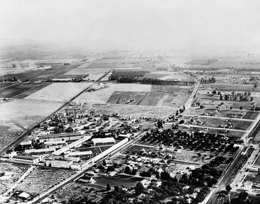
 The site of Culver City, 1913
Movie and television production
 MGM Studios (now Sony Pictures Studios), 1922.
Hundreds of movies have been produced on the lots of Culver City's studios: Sony Pictures Studios (originally MGM Studios), Culver Studios, and the former Hal Roach Studios. These include The Wizard of Oz, The Thin Man, Gone with the Wind, Citizen Kane, Rebecca, the Tarzan series, and the original King Kong. More recent films made in Culver City include Grease, Raging Bull, E.T. the Extra-Terrestrial, City Slickers, Air Force One, Wag the Dog, and Contact. Television shows made on Culver City sets have included Las Vegas, Gunsmoke, Cougar Town, Mad About You, Lassie, Batman, Arrested Development, The Andy Griffith Show, Jeopardy!, The Nanny, and the syndicated version of Wheel of Fortune.
John Travolta's "Stranded at the Drive-In" sequence in Grease was filmed at the Studio Drive-In on the corner of Jefferson and Sepulveda. It served as a set for many other films, including Pee-wee's Big Adventure. The theater was closed in 1993 and was demolished in 1998; it is now a housing subdivision featuring large homes on small lots, as well as being home to the Kayne-ERAS center, a school and community center for the disabled and mentally challenged.
 Downtown Culver City, about 1920
Culver City's streets have been featured in many films and television shows. Since much of the architecture has not changed in decades, particularly in residential areas of town, the nostalgic sitcom The Wonder Years set many of its outdoor scenes in the neighborhoods of Culver City. The 1970s show CHiPs also featured many chase scenes through the streets. The Nicolas Cage film Matchstick Men included scenes made at Veterans Memorial Park, which was also featured in the opening scenes of the sitcom The Hogan Family.
 Sony Pictures Plaza
The Aviator, a film about Howard Hughes, featured several mentions of Culver City in connection with Hughes. The Hughes Aircraft Company plant had a Culver City mailing address but was actually in the adjacent Los Angeles neighborhood of Westchester at a site now called Playa Vista. Scenes from Bewitched (2005) with Nicole Kidman and Will Farrell were also filmed in the Culver City streets. The 2005 film, Fun with Dick and Jane, starring Jim Carrey was filmed there. The closing aerial sequence of Get Shorty (1995) starring John Travolta and Danny DeVito is also filmed in Culver City, at the Sony Studios.
Decline of the studios (1960s and 1970s)
In the late 1960s, much of the MGM back lot acreage (lot 3 and other property on Jefferson Boulevard), and the nearby 28.5 ac (11.5 ha) of the somewhat inaccurately named "back forty", once owned by RKO Pictures and later Desilu Productions, were sold by their owners. In 1976, the sets were razed to make way for redevelopment. Today the "back forty" is the southern expansion of the Hayden Industrial Tract, while the MGM property has been converted to a subdivision and a shopping center known as Raintree Plaza.
Rebirth of downtown (1990s and 2000s)
 Culver Center
In the 1990s, Culver City launched a successful revitalization program in which it renovated its downtown as well as several shopping centers in the Sepulveda Boulevard corridor near Fox Hills Mall. Around the same time, the relocation of Sony's motion picture operations (known as Columbia Pictures)[14] to the former MGM studios at Washington Boulevard and Overland Avenue brought much-needed jobs to the city.
The influx of many art galleries and restaurants to the eastern part of the city, formally designated as the Culver City Art District,[15] prompted The New York Times in 2007 to praise the new art scene and call Culver City a "nascent Chelsea."
Transportation
The first phase of the Expo line, a light rail line from Downtown Los Angeles to a terminal station at the Culver Junction near Venice and Robertson Boulevards in Culver City started in 2006, with an estimated completion date in 2012. The line mostly follows the right-of-way the Pacific Electric Santa Monica Air Line used. The intent of the Los Angeles Metropolitan Transportation Authority is that the line eventually be extended westward to Santa Monica, again mostly along the existing right of way.
Culver City Bus currently operates bus service within Culver City.[16]
The city is served by the Los Angeles International Airport, which is located about 7 miles (11 km) south of the city.
Points of interest
Businesses
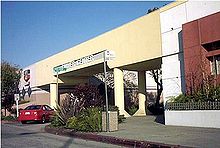
- Culver Hotel:[17] A 1924 landmark pie-slice-shaped hotel in downtown. Many of the cast of The Wizard of Oz stayed here during filming of the movie in 1939. The hijinks of that period, including the hotel's being taken over by the "Munchkins," were featured in the 1981 movie Under the Rainbow. Formerly owned by John Wayne, the hotel has housed many stars including Clark Gable, Greta Garbo, Joan Crawford, Red Skelton, Buster Keaton and Ronald Reagan.
- Helms Bakery,[18] now a center for restaurants, art galleries, the Jazz Bakery (a jazz club), and furniture sales rooms.
- Sony Pictures Plaza:[19] This unusual, cantilevered building was featured as the headquarters of Wolfram & Hart, the demonic law firm that was the chief nemesis in the TV Show Angel. The building is across the street from the main gate of Sony Studios, which is at 10202 W. Washington Boulevard (occupying the former MGM Studio facilities).
Education and research
- Star Eco Station[20] is an environmental science and wildlife rescue center; the STAR ECO Station houses exotic animals that have been abandoned or confiscated and teaches learners of all ages about the environment. At 10101 W. Jefferson Blvd., it offers organized tours. The STAR ECO Station shares its facility with STAR Prep Academy:[21] a Middle-High School that provides hands on opportunities to work with the animals on site.
- West Los Angeles College[22] is a two-year community college within adjacent unincorporated county territory of Baldwin Hills, California. (Thomas Guide Los Angeles County, page 673.)
Local landmarks
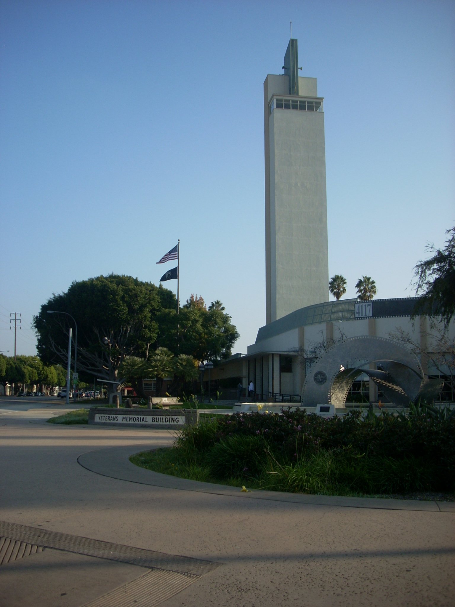
 Veterans Memorial Building with bell tower at Culver Blvd. and Overland Ave.
- Heritage Fountain at Culver City Hall.
- King Fahd Mosque, which can accommodate more than 2,000 worshippers and features a minaret that is more than 70 feet (21 m) in height.[23][dead link]
- Veterans Memorial Building at Veterans Park; tower is 122 feet (37 m) high.
- Hillside Memorial Park Cemetery
- St. Augustine Catholic Church
- Holy Cross Cemetery is the final resting place to Sharon Tate, Bela Lugosi, and punk legend Darby Crash. Nazli Sabri, mother of King Farouk, was also buried there (she had converted to Catholicism in 1950).
Museums and the arts
- The Actors' Gang[24] at the Ivy Substation (within the Palms district, city of Los Angeles, but on long-term lease to Culver City).
- Culver City Art District:[25] A cluster of more than 30 contemporary art galleries in the vicinity of Washington and La Cienega Boulevards.
- Culver City Public Theatre:[26] presents an annual summer season of free, outdoor, classical theatre in beautiful Dr. Paul Carlson Memorial Park, at the corner of Motor Avenue and Braddock Drive (near the 405 and 10 Freeways) in Culver City, CA as well as a yearly tradition of presenting theater for young audiences, the Children's Popcorn Theatre. All performances are held during the summer on Saturdays and Sundays at 2 p.m., with the Children’s Popcorn Theater performance at noon.
- Kirk Douglas Theatre,[27] featuring the Center Theater Group
- The Museum of Jurassic Technology [28]
Recreation
- Ballona Creek bicycle path
- Culver Boulevard Median bicycle path, a greenway featuring bicycle and pedestrian trailways.
- Culver Ice Arena[29] is a public ice skating rink.
Neighborhoods
 See also: Category: Neighborhoods in Culver City, California
Neighborhoods[30]
- Beverlywood West
- Blair Hills
- Blanco
- Carlson Park
- Clarkdale
- Culver Crest
- Culver West
- Downtown Culver City
- Federal Park
- Fox Hills
- Hayden Tract
- Helms District
- Higuera
- Lucerne
- Jefferson
- McLaughlin
- McManus (East Culver City)
- Park East
- Rancho Higuera
- Studio Estates
- Studio Village (Lindberg Park)
- Sunkist Park (El Marino)
- Telefson Park
- Veterans Park (Park West)
- Veterans Park
Economy
Among the companies based in Culver City are Sony Pictures Entertainment and Sizzler.
According to the City's 2010 Comprehensive Annual Financial Report,[31] the top employers in the city are:
# Employer # of Employees 1 Sony Pictures Entertainment 6,000 2 Goldrich & Kest Industries 1,100 3 Culver City Unified School District 1,084 4 Brotman Medical Center 860 5 City of Culver City 700 6 Security Industry Specialists 400 7 Target 400 8 Moldex 300 9 Karl Storz Endoscopy 300 10 Kayne Eras Center 300 Geography
The city is surrounded by the Los Angeles neighborhoods of Mar Vista, West Los Angeles and Palms to the north; Westchester to the south; the Baldwin Hills and Ladera Heights unincorporated areas to the east; and the L.A. neighborhoods of Venice and Playa Vista to the west, along with the unincorporated area of Marina Del Rey.
The two primary ZIP codes for Culver City are 90230 and 90232. Because ZIP codes do not necessarily follow city boundaries, a portion of Culver City is in the 90066 ZIP code, which also serves some of the Mar Vista neighborhood of the city of Los Angeles.
The major geographic feature of Culver City is Ballona Creek, which runs northeast to southwest through most of the city before it drains into Santa Monica Bay in Marina Del Rey.
Culver City is served by the San Diego, Santa Monica, and Marina freeways.
Culver City is at 34°0′28″N 118°24′3″W / 34.00778°N 118.40083°W (34.007761, -118.400905).[32] According to the United States Census Bureau, the city has a total area of 5.1 square miles (13.2 km2), over 99% of which is land.
Climate
Climate data for Culver City, California Month Jan Feb Mar Apr May Jun Jul Aug Sep Oct Nov Dec Year Average high °F (°C) 67.3
(19.6)68.6
(20.3)69.3
(20.7)72.6
(22.6)73.5
(23.1)77.1
(25.1)80.0
(26.7)81.1
(27.3)80.2
(26.8)77.0
(25.0)71.6
(22.0)67.7
(19.8)73.8 Daily mean °F (°C) 56.7
(13.7)57.9
(14.4)59.2
(15.1)62.3
(16.8)64.6
(18.1)68.0
(20.0)70.8
(21.6)71.7
(22.1)70.8
(21.6)67.1
(19.5)61.2
(16.2)57.0
(13.9)63.9 Average low °F (°C) 46.1
(7.8)47.2
(8.4)49.1
(9.5)52.0
(11.1)55.7
(13.2)58.8
(14.9)61.5
(16.4)62.2
(16.8)61.3
(16.3)57.2
(14.0)50.8
(10.4)46.3
(7.9)54.0 Rainfall inches (mm) 3.19
(81)3.25
(82.6)2.66
(67.6)0.58
(14.7)0.26
(6.6)0.04
(1)0.02
(0.5)0.07
(1.8)0.08
(2)0.33
(8.4)0.94
(23.9)1.90
(48.3)13.32
(338.3)Avg. rainy days (≥ 0.01 inch) 5.7 5.3 5.8 1.7 0.7 0.2 0.3 0.2 0.6 1.1 1.9 4.0 27.5 Source: NOAA[33] Education
Primary and secondary schools
Culver City has its own school district, Culver City Unified School District. It has five elementary schools, a middle school, two high schools (regular and continuation), a Community Day School, an Office of Child Development, and an Adult School. In addition, there is an Independent Study program where students of elementary, middle school, or high school age can make a weekly appointment to drop off and pick up homework, which is to be completed throughout the week.
STAR Prep Academy, a private middle and high school, was established in 2004 and shares its campus with the STAR ECO Station, an exotic wildlife rescue center. It is one of the few schools in the United States in which students have the unique opportunity to work with exotic and endangered animals on a daily basis as part of their school-day curriculum.[21]
Colleges and universities
West Los Angeles College, located in an unincorporated section of Los Angeles County adjacent to Culver City,[34] is part of the Los Angeles Community College District. Antioch University Los Angeles is also located in Culver City, off Slauson Avenue. Additionally, Culver City is home to Pepperdine University's Graduate School of Education and Psychology and Graziadio School of Business and Management, located in the Howard Hughes Center.
Other
The Los Angeles County Probation Department's Training Academy is housed on the campus of West L.A. College.
Culver City is the location for the Los Angeles area campus of the Gemological Institute of America as well as Culver Beauty College and the Biofeedback Institute of Los Angeles.
Demographics
2010
The 2010 United States Census[35] reported that Culver City had a population of 38,883. The population density was 7,566.0 people per square mile (2,921.2/km²). The racial makeup of Culver City was 23,450 (60.3%) White, 3,694 (9.5%) African American, 191 (0.5%) Native American, 5,742 (14.8%) Asian, 81 (0.2%) Pacific Islander, 3,364 (8.7%) from other races, and 2,361 (6.1%) from two or more races. Hispanic or Latino of any race were 9,025 persons (23.2%).
The Census reported that 38,572 people (99.2% of the population) lived in households, 84 (0.2%) lived in non-institutionalized group quarters, and 227 (0.6%) were institutionalized.
There were 16,779 households, out of which 4,499 (26.8%) had children under the age of 18 living in them, 6,826 (40.7%) were opposite-sex married couples living together, 1,882 (11.2%) had a female householder with no husband present, 636 (3.8%) had a male householder with no wife present. There were 922 (5.5%) unmarried opposite-sex partnerships, and 157 (0.9%) same-sex married couples or partnerships. 5,649 households (33.7%) were made up of individuals and 1,956 (11.7%) had someone living alone who was 65 years of age or older. The average household size was 2.30. There were 9,344 families (55.7% of all households); the average family size was 3.01.
The population was spread out with 7,312 people (18.8%) under the age of 18, 2,711 people (7.0%) aged 18 to 24, 12,098 people (31.1%) aged 25 to 44, 10,956 people (28.2%) aged 45 to 64, and 5,806 people (14.9%) who were 65 years of age or older. The median age was 40.5 years. For every 100 females there were 89.1 males. For every 100 females age 18 and over, there were 85.6 males.
There were 17,491 housing units at an average density of 3,403.5 per square mile (1,314.1/km²), of which 9,111 (54.3%) were owner-occupied, and 7,668 (45.7%) were occupied by renters. The homeowner vacancy rate was 0.7%; the rental vacancy rate was 4.1%. 21,549 people (55.4% of the population) lived in owner-occupied housing units and 17,023 people (43.8%) lived in rental housing units.
2000
As of the census[36] of 2000, there were 38,816 people, 16,611 households, and 9,518 families residing in the city. The population density was 7,589.8 inhabitants per square mile (2,932.9/km²). There were 17,130 housing units at an average density of 1,294.3/km ² (3,349.5/mi²). The racial makeup of the city was 59.24% White, 11.96% Black or African American, 0.71% Native American, 12.02% Asian, 0.21% Pacific Islander, 10.16% from other races, and 5.69% from two or more races. 23.70% of the population were Hispanic or Latino of any race.
There were 16,611 households out of which 26.1% had children under the age of 18 living with them, 40.8% were married couples living together, 12.8% had a female householder with no husband present, and 42.7% were non-families. 34.5% of all households were made up of individuals and 9.3% had someone living alone who was 65 years of age or older. The average household size was 2.31 and the average family size was 3.02.
In the city the population was spread out with 20.9% under the age of 18, 6.6% from 18 to 24, 33.3% from 25 to 44, 25.3% from 45 to 64, and 13.9% who were 65 years of age or older. The median age was 39 years. For every 100 females there were 87.5 males. For every 100 females age 18 and over, there were 82.7 males.
The median income for a household in the city was $51,792, and the median income for a family was $61,451 (these figures had risen to $65,525 and $82,582 as of a 2007 estimate[37]). Males had a median income of $46,683 versus $41,478 for females. The per capita income for the city was $29,025. About 5.5% of families and 8.6% of the population were below the poverty line, including 12.1% of those under age 18 and 5.1% of those age 65 or over.
Government and infrastructure
In Los Angeles County, Culver City is located in the 2nd Supervisorial District, currently represented by Mark Ridley-Thomas. In the state legislature Culver City is located in the 26th Senate District, represented by Democrat Curren D. Price, Jr., and in the 47th Assembly District, represented by Democrat Holly J. Mitchell. Federally, Culver City is located in California's 33rd congressional district, which has a Cook PVI of D +36[38] and is represented by Democrat Karen Bass.
The Los Angeles County Department of Health Services SPA 5 West Area Health Office serves Culver City.[39] The department operates the Simms/Mann Health and Wellness Center in Santa Monica, serving Culver City.[40]
The United States Postal Service operates the Culver City Post Office at 11111 Jefferson Boulevard and the Gateway Post Office at 9942 Culver Boulevard.[41][42]
Culver City is served by its own police force, the Culver City Police Department, located at 4040 Duquesne Avenue.[43]
Sister cities
Culver City has four sister cities, as designated by Sister Cities International:
Noted natives
Categories:- Culver City, California
- Cities in Los Angeles County, California
- Incorporated cities and towns in California
- Populated places established in 1913
- 1917 establishments in the United States


Wikimedia Foundation. 2010.