- Atlit
-
For the Crusader fortress, see Chateau Pelerin.
Atlit 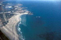
Atlit coastlineHebrew עַתְלִית Also spelled Atlith (unofficially)
Founded 1903 District Haifa Coordinates 32°41′14″N 34°56′18″E / 32.68722°N 34.93833°ECoordinates: 32°41′14″N 34°56′18″E / 32.68722°N 34.93833°E Population 5,300[1] (2008) 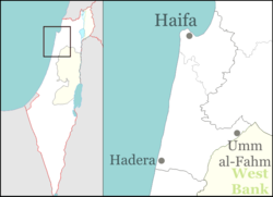
 Atlit
AtlitAtlit (Hebrew: עַתְלִית) is a coastal town located south of Haifa, Israel. Originally an outpost of the Crusaders, it fell in 1291. The modern village was founded in 1903 under the auspices of Baron Edmond de Rothschild. The population today is 5,300.[1] The Atlit detainee camp is nearby.
Contents
History
 Nineteenth century map
Atlit Yam is an ancient submerged Neolithic village off the coast of Atlit, Israel. Atlit-Yam provides the earliest known evidence for an agro-pastoral-marine subsistence system on the Levantine coast.[2]
Atlit shows evidence of human habitation since the early Bronze Age. The Crusaders built Chateau Pelerin, one of the largest citadels in the Holy Land, and one of the last remaining Crusader outposts to withstand the assaults of Baibars (see also: Fall of Ruad). Atlit remained in Crusader hands until 1291. The ruins of the citadel are still visible in modern times.
In 1880, the Survey of Western Palestine notes the existence of a small Arab village of mud huts with a population of 200. In 1903, Jewish settlers build a nearby village which they also called Atlit. During the British Mandate of Palestine, the Arab and Jewish villages were treated statistically as part of the same community. In 1938 there were 508 Arabs and 224 Jews. The Arab presence underwent a sharp decline in the 1940s due to land sales, so that by 1944/5 there were only 150 Arabs still living there (90 Muslims and 60 Christians) alongside about 2,000 Jews. The circumstances under which the remaining Arabs left in 1948 are unknown.[3]
Atlit was declared a local council in 1950, but in 2004 was incorporated in the Hof HaCarmel Regional Council as one of a handful of Regional Committees.
Atlit detainee camp was used by the British authorities to detain Jewish immigrants to Palestine.[4] It is now a museum of the Ha'apala. A base of Israel's naval commando is located nearby.
Former Knesset member Pesah Grupper lives in Atlit, and was head of its local council in 1959-1962, and 1969-1971.
Neighborhoods
Neighborhoods in Atlit are Neve Moshe, Yamit, Giv'at HaPrahim, Giv'at HaBrekhot, Giv'at Sharon, Shoshanat HaYam, HaGoren, Yafe Nof, Argaman, Hofit, Savyonei Atlit and Allon. Atlit is in immediate vicinity of the villages Neve Yam and Ein Carmel.
See also
- Atlit naval base
References
- ^ a b "Table 3 - Population of Localities Numbering Above 2,000 Residents and Other Rural Population". Israel Central Bureau of Statistics. 2010-06-30. http://www.cbs.gov.il/population/new_2010/table3.pdf. Retrieved 2010-12-07.
- ^ Marine archaeology
- ^ W. Khalidi, All that Remains, p146-147; B. Morris, The Birth of the Palestinian Refugee Problem Revisited, pxviii.
- ^ http://www.hadassah.com/news/content/per_hadassah/archive/2003/03_FEB/traveler.htm
Kibbutzim Beit Oren · Ein Carmel · HaHotrim · Ma'agan Michael · Ma'ayan Tzvi · Nahsholim · Neve Yam · Sdot YamMoshavim Bat Shlomo · Beit Hanania · Dor · Ein Ayala · Geva Carmel · HaBonim · Kerem Maharal · Megadim · Nir Etzion · Ofer · TzrufaCommunal settlements Other villages Categories:- Hof HaCarmel Regional Council
- Atlit
- Jewish villages in the Ottoman Empire


Wikimedia Foundation. 2010.