- Menominee Pier Light
-
Menominee Pier Light 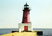
Location Menominee, Michigan Coordinates 45°06′N 87°35′W / 45.1°N 87.583°WCoordinates: 45°06′N 87°35′W / 45.1°N 87.583°W Year first lit 1927 Automated 1972 Foundation Concrete pier Construction Cast iron Tower shape Octagonal Markings / pattern red Daymark with black lantern and white base Height Tower - 34 feet (10 m) Focal height Focal plane - 46 feet (14 m) Original lens Fourth Order Fresnel lens Current lens 300 mm Tideland Signal acrylic Range 10 nautical miles (19 km) Characteristic Fl R 4s ARLHS number USA-490 USCG number 7-21935 The Menominee North Pier lighthouse is located in the harbor of Menominee, Michigan. The station was established in 1877. The current structure and its still operational light was first lit in 1927, and automated in 1972.[1] It is also sometimes called the "Menominee (Marinette) North Pierhead Light".[2]
The foundation is a concrete pier. The 34-foot (10 m) tall octagonal cast iron building is marked in a distinctive red, with a black lantern and white base. A Fourth Order Fresnel lens was originally installed, but was replaced with a modern 300 mm. acrylic optic lens.[3] The original lens is now at Sand Point Light in Escanaba, Michigan.[4] The focal plane is 46 feet.[5]
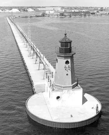
The building originally had a diaphone fog signal structure attached, and it was later removed. The iron catwalk was removed in 1972 when the light was automated.[6]
This light is paired with a large rear range light.[7] That is denominated the Menominee (Marinette) North Pier light, and is also an active aid to navigation. Its focal plane 59 ft (18 m), and its characteristic is a continuous red light. The tower is a 50 ft (15 m) square pyramidal steel skeletal tower with gallery. It is painted red, and located on the Menominee North Pier about 600 ft (180 m) from the pierhead light.[8] It may be accessed by walking the pier. The site is open, but the tower is closed. U.S. Coast Guard. USCG 7-21940.[2]
Directions
 US 41 enters Menominee and makes a 90 degree turn onto 10th Street (heading east to west) as it passes through downtown. Go east on 10th Street towards Lake Michigan to 1st street. Turn south onto 1st Street, then turn east onto Harbor Drive. Harbor Drive parallels the lakeshore, ending at a parking lot. A short walk on a wooden walkway leads to the large, flat breakwater.[9]
References
- ^ "Historic Light Station Information and Photography: Michigan". United States Coast Guard Historian's Office. http://www.uscg.mil/history/weblighthouses/LHMI.asp.
- ^ a b Rowlett, Russ. "Lighthouses of the United States: Michigan's Eastern Upper Peninsula". The Lighthouse Directory. University of North Carolina at Chapel Hill. http://www.unc.edu/~rowlett/lighthouse/miup.htm.
- ^ Terry Pepper, Seeing the Light, 300 mm. acrylic optic lens.
- ^ Wobser, David, Menoninee Pier Light at Boatnerds.com.
- ^ National Park Service, Maritime Herirage Inventory of Historic Lights, Menoninee Pier Light.
- ^ Terry Pepper, Seeing the Light, Menoninee Pier Light.
- ^ Lighthoues R US, Menoninee Pier Lights.
- ^ See the photo, National Park Service, Maritime Heritage Inventory of Historic Lights, Menoninee North Pier Light.
- ^ Lighthouse friends, Menoninee North Pier Light.
 Undated USCG aerial photo, showing catwalk (since removed)
External links
 Early undated USCG image of light and attached fog signal building
- Detroit News, Interactive map on Michigan lighthouses.
- Interactive map of Lights in Northern Lake Michigan, mapped by Google.
- Lighthouse Central, Menominee North Pier Light, The Ultimate Guide to Upper Michigan Lighthouses by Jerry Roach.. (Publisher: Bugs Publishing LLC - 2007). ISBN 978-0-9747977-2-4.
- Lighthouse depot, Menoninee Pier Light.
- Lighthouse friends, Menoninee North Pier Light.
- Michigan Lighthouse Conservancy, Menoninee North Pier Light.
- Map of Michigan Lighthouse in PDF Format.
- Terry Pepper, Seeing the Light, Menoninee Pier Light.
- National Park Service , Maritime Heritage Inventory of Historic Lights, Menoninee North Pier Light.
- Map of lighthouses in western Lake Michigan.
- (PDF) Light List, Volume VII, Great Lakes. Light List. United States Coast Guard. http://www.navcen.uscg.gov/pdf/lightLists/LightList%20V7.pdf.
Lighthouses of Michigan See also: List of lighthouses in Michigan Northern upper peninsula Au Sable Light • Big Bay Point Light • Copper Harbor Light • Copper Harbor Front Range Light • Crisp Point Light • Eagle Harbor Light • Eagle Harbor Range Lights • Eagle River Light • Fourteen Mile Point Light • Grand Island East Channel Light • Grand Island Harbor Rear Range Light • Grand Island North Light • Granite Island Light • Gull Rock Light Station • Huron Island Light • Isle Royale Light • Manitou Island Light Station • Marquette Harbor Light • Mendota (Bete Grise) Light • Munising Front Range Light • Munising Rear Range Light • Portage River (Jacobsville) Light • Passage Island Light • Rock Harbor Light • Rock of Ages Light • Sand Hills Light • St. Martin Island Light • Stannard Rock Light • Thunder Bay Island Light • Whitefish Point LightSouthern upper peninsula DeTour Reef Light • Manistique East Breakwater Light • Martin Reef Light • Menominee Pier Light • Naubinway Island Light • Peninsula Point Light • Poverty Island Light • Sand Point Light Escanaba • Sand Point Light Baraga • Seul Choix Light • Squaw Island Light • White Shoal LightSt. Mary's River Frying Pan Island Light • Pipe Island Light • Point Iroquois Light • Round Island Light (St. Mary's River) • Six Mile Point Range Rear LightPortage River/Ship Canal Keweenaw Waterway (Portage Lake) Lower Entrance • Keweenaw Waterway Upper Entrance Light • Rouleau Point Range Front and Rear LightsStraits of Mackinac Bois Blanc Light • McGulpin Point Light • Old Mackinac Point Light • Round Island Light • Round Island Passage • St. Helena Island LightWestern lower peninsula Beaver Island Harbor Light • Beaver Island Head Light • Big Sable Point Light • Charlevoix Light • Charlevoix South Pier Light • Frankfort Light • Frankfort South Range Light • Grand Haven Light • Grand Haven South Pierhead Outer Light • Grand Haven Main Light • Gray's Reef Light • Holland Harbor Light • Ile Aux Galets • Little Sable Point Light • Little Traverse Light • Ludington Light • Manistee Main Light • Manistee Pierhead lights • Miller Memorial Light • Mission Point Light • Mission Point Light (2) • Muskegon Breakwater Light • Muskegon Pier Light • Point Betsie Light • South Fox Island • South Haven Light • South Manitou Island Light • Waugoshance Light • White River LightEastern lower peninsula Alpena Light • Bellanger Park (Ecorse) Light • Caseville Harbor (Saginaw Bay) • Belle Isle Light • Charity Island Light • Cheboygan River Range Front Light • Cheboygan Crib Light • Detroit River Light • Fort Gratiot Light • Forty Mile Point Light • Fourteen Foot Shoal Light • Gibraltar Light • Gravelly Shoal Light • Harbor Beach Light • Manning Memorial Light • Mariners Memorial (River Rouge) Light • New Presque Isle Light • Old Presque Isle Light • Poe Reef Light • Pointe aux Barques Light • Port Austin Light • Port Sanilac Light • Saginaw River Range Front Light • Saginaw River Rear Range Light • Spectacle Reef Light • St. Clair Flats Front and Rear Range Light • Sturgeon Point Light • Tawas Point Light • Tri-Centennial Light of Detroit • William Livingtone Memorial LightHistorical (lost) lights Au Sable North Pierhead • Clinton River Light • Ecorse Light • Ecorse Range Rear • Gibraltar Light • Grassy Island Lighthouse • Grassy Island North Channel Range • Grassy Island South Channel Range • Grosse Isle South Channel Range • Harwood Point East Range Front (St. Mary's River) • Mama Juda Light • Mama Juda Range Front • Middle Lake George • Monroe Pier • New Buffalo • North Manitou Island • Rouleau Point Range Front and Rear • Saginaw Bay • Sand Beach North Entrance East • Squaw Point • St. Mary's River Lower Range Front • Turtle Island Light • Vidal Shoals Channel Range Front and Rear • Windmill Point Range Front and Rear • Winter Point Range FrontRelated – Lightship Huron, List of lifesaving stations in Michigan U.S. National Register of Historic Places Topics Lists by states Alabama • Alaska • Arizona • Arkansas • California • Colorado • Connecticut • Delaware • Florida • Georgia • Hawaii • Idaho • Illinois • Indiana • Iowa • Kansas • Kentucky • Louisiana • Maine • Maryland • Massachusetts • Michigan • Minnesota • Mississippi • Missouri • Montana • Nebraska • Nevada • New Hampshire • New Jersey • New Mexico • New York • North Carolina • North Dakota • Ohio • Oklahoma • Oregon • Pennsylvania • Rhode Island • South Carolina • South Dakota • Tennessee • Texas • Utah • Vermont • Virginia • Washington • West Virginia • Wisconsin • WyomingLists by territories Lists by associated states Other  Category:National Register of Historic Places •
  Portal:National Register of Historic PlacesCategories:
- Lighthouses in Michigan
- Buildings and structures in Menominee County, Michigan
- National Register of Historic Places in Michigan
- Visitor attractions in Menominee County, Michigan


Wikimedia Foundation. 2010.