- Manley Hot Springs, Alaska
-
Manley Hot Springs
Too Naaleł Denh— CDP — Manley Hot Springs welcome sign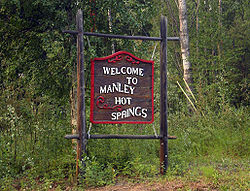 Location of Manley Hot Springs, Alaska
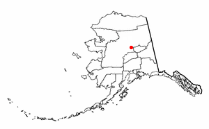
Coordinates: 65°0′28″N 150°37′36″W / 65.00778°N 150.62667°WCoordinates: 65°0′28″N 150°37′36″W / 65.00778°N 150.62667°W Country United States State Alaska Census Area Yukon-Koyukuk Area - Total 54.3 sq mi (140.6 km2) - Land 54.3 sq mi (140.6 km2) - Water 0.0 sq mi (0.0 km2) Population (2000) - Total 72 - Density 1.3/sq mi (0.5/km2) Time zone Alaska (AKST) (UTC-9) - Summer (DST) AKDT (UTC-8) Area code 907 FIPS code 02-46780 Manley Hot Springs (Too Naaleł Denh in Koyukon) is a census-designated place (CDP) in Yukon-Koyukuk Census Area, Alaska, [[United States. At the 2000 census the population was 72.
Contents
Geography
Manley Hot Springs is located at 65°0′28″N 150°37′36″W / 65.00778°N 150.62667°W (65.007773, -150.626732)[1].
Manley Hot Springs is located about 8 km (5.0 mi) north of the Tanana River on Hot Springs Slough, at the end of the Elliott Highway, 260 km (160 mi) west of Fairbanks.
According to the United States Census Bureau, the CDP has a total area of 54.3 square miles (141 km2), all of it land.
Demographics
As of the census[2] of 2000, there were 72 people, 36 households, and 19 families residing in the CDP. The population density was 1.3 people per square mile (0.5/km²). There were 105 housing units at an average density of 1.9/sq mi (0.7/km²). The racial makeup of the CDP was 73.61% White, 23.61% Native American, and 2.78% from other races.
There were 36 households out of which 19.4% had children under the age of 18 living with them, 47.2% were married couples living together, 5.6% had a female householder with no husband present, and 47.2% were non-families. 38.9% of all households were made up of individuals and 2.8% had someone living alone who was 65 years of age or older. The average household size was 2.00 and the average family size was 2.58.
In the CDP the population was spread out with 15.3% under the age of 18, 4.2% from 18 to 24, 30.6% from 25 to 44, 37.5% from 45 to 64, and 12.5% who were 65 years of age or older. The median age was 44 years. For every 100 females there were 125.0 males. For every 100 females age 18 and over, there were 110.3 males.
The median income for a household in the CDP was $29,000, and the median income for a family was $59,583. Males had a median income of $36,250 versus $16,250 for females. The per capita income for the CDP was $21,751. There were no families and 9.7% of the population living below the poverty line, including no under eighteens and none of those over 64.
History
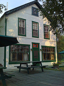 Manley Roadhouse was built in 1903 and still serves the community as its only restaurant and hotel.
In 1902 a prospector, John Karshner, discovered several hot springs in the area. He began a homestead and vegetable farm. In the same year, the United States Army built a telegraph station. The area became a service and supply point for miners in the Tofty and Eureka mining districts. It was known as Baker's Hot Springs, after nearby Baker Creek.
Farming and livestock operations in the area produced fresh meat, poultry, and produce for sale. In 1903, Sam's Rooms and Meals, now called the Manley Roadhouse, opened. The Manley Roadhouse was owned by Robert E Lee, who was also the town's postmaster until his passing in 2010. In 1907 a miner named Frank Manley built the Hot Springs Resort Hotel. The resort was a four-story building with 45 guest rooms, steam heat, electric lights, hot baths, a bar, a restaurant, a billiard room, a bowling alley, a barber shop, and an Olympic-size indoor swimming pool which used heated water from the hot springs. During the summer, the hotel's private boat transported guests from steamers on the Tanana River. In the winter, an overland stagecoach trip from Fairbanks took two days. The town was renamed Hot Springs.
The resort and the mining in the area caused the town to prosper. It had a store, a newspaper, a bakery, clothing stores and other businesses. The population of the area in 1910 was more than 500. In 1913 the resort burned to the ground. Mining activity was also in decline and by 1920 only 29 residents lived in Hot Springs.
The town's name was changed to Manley Hot Springs in 1957.
In 1985, a local optimistic businesswoman named Rina Krevat saw an opportunity to further build the resort industry feeding off the natural hot water. She proceeded to open a new resort with natural hot tubs that same year.
Transportation
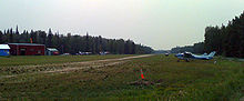 Manley Hot Springs Airport is supported by the Essential Air Service program.
The Elliott Highway, completed 1959, gives Manley Hot Springs road access from Fairbanks year-round. Before 1982 it was not plowed by the state and closed during the winter.
The Manley Hot Springs Airport has scheduled flights.
References
- ^ "US Gazetteer files: 2010, 2000, and 1990". United States Census Bureau. 2011-02-12. http://www.census.gov/geo/www/gazetteer/gazette.html. Retrieved 2011-04-23.
- ^ "American FactFinder". United States Census Bureau. http://factfinder.census.gov. Retrieved 2008-01-31.
Municipalities and communities of Yukon-Koyukuk Census Area, Alaska Cities 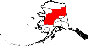
CDPs Alatna | Arctic Village | Beaver | Birch Creek | Central | Chalkyitsik | Circle | Coldfoot | Evansville | Flat | Four Mile Road | Lake Minchumina | Livengood | Manley Hot Springs | Minto | New Allakaket | Rampart | Stevens Village | Takotna | Venetie | Wiseman
Unincorporated
communitiesCategories:- Census-designated places in Alaska
- Populated places in Yukon–Koyukuk Census Area, Alaska
- Hot springs of Alaska
- Landforms of Yukon–Koyukuk Census Area, Alaska


Wikimedia Foundation. 2010.