- Midwestern United States
-
"Midwest" redirects here. For other uses, see Midwest (disambiguation).
 Midwest as defined by U.S. Census Bureau
The Midwestern United States is one of the four U.S. geographic regions defined by the United States Census Bureau, providing an official definition of the American Midwest.
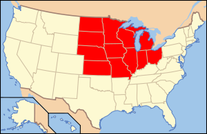
The region consists of 12 states in the north-central and north-eastern United States: Illinois, Indiana, Iowa, Kansas, Michigan, Minnesota, Missouri, Nebraska, North Dakota, Ohio, South Dakota and Wisconsin.[1] A 2010 United States Census put the population at 66,927,001. Both the population center and the geographic center of the contiguous United States are in the Midwest, in Missouri and Kansas, respectively.
Chicago is the largest city in the region, followed by Indianapolis, Columbus, Detroit, and Milwaukee. Chicago and its suburbs form the largest metropolitan statistical area, followed by Metro Detroit, the Twin Cities, Greater Cleveland, Metro St. Louis and Kansas City area.[2] Sault Ste. Marie, Michigan is the oldest city in the region, having been founded by French missionaries and explorers in 1668.
The term Midwestern has been in use since the 1880s to refer to portions of the central U.S.[3] A variant term, "Middle West," has been in use since the 19th century and remains relatively common.[4] Another term sometimes applied to the same general region is "the heartland".[5] Other designations for the region have fallen into disuse, such as the "Northwest" or "Old Northwest" (from "Northwest Territory") and "Mid-America". The four westernmost states of the Midwest—the Dakotas, Kansas and Nebraska—were in the late 19th century very much part of the "Old West".
Since the book Middletown appeared in 1929, sociologists once used Midwestern cities (and the Midwest generally) as "typical" of the entire nation, however coastal cities are now considered the epicenter of American culture often portrayed in the media.[6][7] The region has a higher employment-to-population ratio (the percentage of employed people at least 16 years old) than the Northeast, the West, the South, or the Sun Belt states, most probably due to the region's relatively smaller populations.[8]
The U.S. Census Bureau further divides the Midwest into two distinct regions, the East North Central "Great Lakes States," which include Michigan, Ohio, Indiana, Illinois, Wisconsin, and Minnesota (Midwestern states that come in contact with a Great Lake), and the West North Central "Great Plains States," which include Iowa, Missouri, North Dakota, South Dakota, Nebraska and Kansas (states that are located within the Great Plains region of the country).
Contents
- 1 Definition
- 2 Physical geography
- 3 Prehistory
- 4 History
- 5 Farming and agriculture
- 6 Major metropolitan areas
- 7 Politics
- 8 See also
- 9 Notes
- 10 References
Definition
 Modern Definitions: The states in solid red are almost always identified as being part of the Midwest, while striped states are classified as such with less frequency[original research?]
Traditional definitions of the Midwest include the Northwest Ordinance "Old Northwest" states and many states that were part of the Louisiana Purchase. The states of the Old Northwest are also known as "Great Lakes states". Many of the Louisiana Purchase states are also known as "Great Plains states".
The North Central Region is defined by the U.S. Census Bureau as these 12 states:
- Illinois: Old Northwest, Ohio River, and Great Lakes state.
- Indiana: Old Northwest, Ohio River, and Great Lakes state.
- Iowa: Louisiana Purchase.
- Kansas: Louisiana Purchase, Great Plains state.
- Michigan: Old Northwest and Great Lakes state.
- Minnesota: Old Northwest, Louisiana Purchase, part of Red River Colony before 1818, Great Lakes state.
- Missouri: Louisiana Purchase, Border state.
- Nebraska: Louisiana Purchase, Great Plains state.
- North Dakota: Louisiana Purchase, part of Red River Colony before 1818, Great Plains state.
- Ohio: Old Northwest (Historic Connecticut Western Reserve), Ohio River, and Great Lakes state. The southeastern part of the state is part of Northern Appalachia.
- South Dakota: Louisiana Purchase, Great Plains state.
- Wisconsin: Old Northwest and Great Lakes state.
Physical geography
 Typical terrain of the Driftless Area as viewed from Wildcat Mountain State Park in Vernon County, Wisconsin.
The vast central area of the U.S., into Canada, is a landscape of low, flat to rolling terrain in the Interior Plains. Most of its eastern two-thirds form the Interior Lowlands. The Lowlands gradually rise westward, from a line passing through eastern Kansas, up to 5,000+ feet in the unit known as the Great Plains). Much of the Plains are now converted land use-wise to farming.[9]
While these states are for the most part relatively flat, consisting either of plains or of rolling and small hills, there is a measure of geographical variation. In particular, the eastern Midwest near the foothills of the Appalachian Mountains; the Great Lakes Basin; the Ozark Mountains of southern Missouri; the rugged topography of Southern Indiana and far Southern Illinois; and the Driftless Area of northwest Illinois, southwest Wisconsin, southeast Minnesota, and northeast Iowa exhibit a high degree of topographical variety.
Proceeding westward, the Appalachian Plateau topography gradually gives way to gently rolling hills and then (in central Ohio) to flat lands converted principally to farms and urban areas. This is the beginning of the vast Interior Plains of North America. As a result, prairies cover most of the states west of the Mississippi River with the exception of taiga-clad northern Minnesota. Illinois lies within an area called the "prairie peninsula", an eastward extension of prairies that borders deciduous forests to the north, east, and south.

Geographers subdivide the Interior Plains into the Interior Lowlands and the Great Plains on the basis of elevation. The Lowlands are mostly below 1,500 feet above sealevel whereas the Great Plains to the west are higher, rising in Colorado to around 5,000 feet. The Lowlands, then, are confined to parts of Minnesota, Iowa, Michigan, Ohio, Indiana, Tennessee, and Kentucky. Missouri and Arkansas have regions of Lowlands elevations but in the Ozarks (within the Interior Highlands) are higher. Those familiar with the topography of eastern Ohio may be confused by this; that region is hilly but its rocks are horizontal and are an extension of the Appalachian Plateau.
The Interior Plains are largely coincident with the vast Mississippi River Drainage System (other major components are the Missouri and Ohio Rivers). These rivers have for tens of millions of years been eroding downward into the mostly horizontal sedimentary rocks of Paleozoic, Mesozoic, and Cenozoic ages. The modern Mississippi River system has developed during the Pleistocen Epoch of the Cenozoic Eraut its rocks are horizontal and are an extension of the Appalachian Plateau.[9]
Rainfall decreases from east to west, resulting in different types of prairies, with the tallgrass prairie in the wetter eastern region, mixed-grass prairie in the central Great Plains, and shortgrass prairie towards the rain shadow of the Rockies. Today, these three prairie types largely correspond to the corn/soybean area, the wheat belt, and the western rangelands, respectively.
Although hardwood forests in the northern Midwest were clear-cut in the late 19th century, they were replaced by new growth. Ohio and Michigan's forests are still growing. The majority of the Midwest can now be categorized as urbanized areas or pastoral agricultural areas.
Prehistory
According to anthropologists and archaeologists, American Indians are virtually immigrants, too. They came to North America through the Beringia land bridge between Asia and North America (it’s said there was once really an ice bridge) about 12,000 years ago. According to the study of ancient Indian skulls by scientists, these people display affinities with populations as diverse as the Ainu of Japan, peoples of central Asia, Australasia, India, southwest Asia, and the Neandertals of Europe.
Prior to European colonization in North America, Native Americans had developed a large population in this vast land, estimated as between 1 million to 18 million, scattered across all of North America. There were many different tribes which belong to several main cultures and societies. In Midwestern America, the American Indians had experienced three main periods before the arrival of Europeans in the 17th century.
Paleoindian cultures was the earliest one, occupied North America, with some restricted to the Great Plains and Great Lakes of the modern United States and Canada, as well as adjacent areas to the west and southwest from about 12,000 B.C. to around 8,000 B.C. These people moved into North America when the continental glaciers of the last great ice age, the Wisconsin glacier period, began to melt.
Following the Paleo-Indian period is the Archaic period (8,000 B.C. to 1,000 B.C.), the Woodland Tradition (1,000 B.C. to 100 A.D.), and the Mississippi Period (900 to 1600 A.D.). Archeological evidence indicates that Mississippi culture probably began in the St. Louis, Missouri area and spread northwest along the Mississippi and Illinois rivers and entered the state along the Kankakee River system. It also spread northward into Indiana along the Wabash, Tippecanoe, and White Rivers.[10]
 Monks Mound, located at the Cahokia Mounds UNESCO World Heritage Site near Collinsville, Illinois, is the largest Pre-Columbian earthwork in America north of Mesoamerica.
The Mississippi period was characterized by a mound-building culture. The namesake cultural trait of the mound builders was their construction of large, truncated earthwork pyramid mounds, or platform mounds, and other earthworks. These burial and ceremonial structures were typically flat-topped pyramids or platform mounds, flat-topped or rounded cones, elongated ridges, and sometimes a variety of other forms. Domestic houses, temples, burial buildings were usually constructed on the tops of such mounds. Prehistoric mounds are common from the plains of the Midwest to the Atlantic seaboard, but only in this general area was there a culture that regularly constructed mounds in the shape of mammals, birds, or reptiles.
Among the most well known are found at Effigy Mounds National Monument in northeastern Iowa, the largest known collection of mounds in the United States.[11] The monument contains 2,526 acres (10.22 km2) with 206 mounds of which 31 are effigies. The others are conical, linear and compound. Woodland period Indians built mounds from about 500 BC until the early European contact period. When the American prairies were plowed under by European settlers for agriculture, many mound sites were lost.
They were built as part of complex villages that attracted more dense populations, with a specialization of skills and knowledge. The best-known, flat-topped pyramidal structure, which at over 100 feet (30 m) tall is the largest pre-Columbian earthwork north of Mexico, is Monks Mound at Cahokia Indian Mounds in Collinsville, Illinois.
The mound builders included many different tribal groups and chiefdoms, involving an array of beliefs and unique cultures over thousands of years. The general term covered their shared architectural practice of earthwork mound construction. This practice, believed to be associated with a cosmology that had a cross-cultural appeal, may indicate common cultural antecedents.
Mississippi Mound tribes in the Midwest were mostly farmers who followed the rich, flat floodplains of Midwestern rivers. They brought with them a well-developed agricultural complex based on three major crops – maize, beans, and squash. Maize, or corn, was the primary crop of Mississippi farmers. They gathered a wide variety of seeds, nuts, and berries, and fished and hunted for fowl to supplement their diets. With such an intensive form of agriculture, Mississippi Mound culture supported a large Indian population.
History
American Indian
Great Lakes Indians
The Great Lakes region –stretching from New York to Minnesota – has played a vital role in the lives and histories of Native American peoples who have resided along their shores for millennia. Tribes living around the Great Lakes area included the Hurons, Ottawa, Chippewas or Ojibwas, Potawatomis, Winnebago (Ho-chunk), Menominees, Sacs, Neutrals, Fox, and the Miami. Most numerous were the Hurons and Chippewas. Fighting and battle were often launched between tribes, with some tribes forced to move around.
Most Indian groups living in the Great Lakes region for the last five centuries are of the Algonquian language family. Some tribes—such as the Stockbridge-Munsee and the Brothertown--are also Algonkian-speaking tribes who relocated from the eastern seaboard to the Great Lakes region in the 19th century. The Oneida belong to the Iroquois language group and the Ho-Chunk of Wisconsin are one of the few Great Lakes tribes to speak a Siouan language.[12] American Indians in this area did not develop a written form of language.
 Winnebago family (1852)
In the 16th century, American Indians used projectiles and tools of stone, bone, and wood to hunt and farm. They could made canoes for fishing. Most of them lived in oval or conical wigwams that could be easily moved away. Various tribes had different ways of living. The Ojibwas were primarily hunters and fishing was also important in the Ojibwas economy. Other tribes such as Sac, Fox, and Miami, who wandered in the south and southwestern section of the Great Lakes region, both hunted and farmed to make their living. They were oriented toward the open prairies where they engaged in communal hunts for buffalo. In the northern forests, the Ottawas and Potawatomis separated into small family groups for hunting. The Winnebagos and Menominees used both hunting methods interchangeably and built up widespread trade networks extending as far west as the Rockies, north to the Great Lakes, south to the Gulf of Mexico, and east to the Atlantic Ocean.
The Hurons reckoned descent through the female line, while the others favored the patrilineal method. All tribes were governed under chiefdoms or complex chiefdoms. For example, Hurons were divided into matrilineal clans, each represented by a chief in the town council, where they met with a town chief on civic matters. But Chippewa people’s social and political life was simpler than that of settled tribes.
The religious beliefs varied among tribes. Hurons believed in Yoscaha, a supernatural being who lived in the sky and was believed to have created the world and the Huron people. At death, Hurons thought the soul left the body to live in a village in the sky. Chippewas were a deeply religious people who believed in the Great Spirit. They worshipped the Great Spirit through all their seasonal activities and viewed religion as a private matter: each person’s relation with his personal guardian spirit was part of his thinking every day of life. Ottawa and Potawatomi people had very similar religious beliefs to that of the Chippewas.[13]
Great Plains Indians
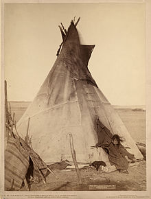 Young Oglala Lakota girl in front of tipi with puppy beside her, probably on or near Pine Ridge Indian Reservation, South Dakota.
The Plains Indians are the indigenous peoples who live on the plains and rolling hills of the Great Plains of North America. Their colorful equestrian culture and resistance to white domination have made the Plains Indians archetypical in literature and art for American Indians everywhere.
Plains Indians are usually divided into two broad classifications which overlap to some degree. The first group were fully nomadic, following the vast herds of buffalo. Some tribes occasionally engaged in agriculture; growing tobacco and corn primarily. These included the Blackfoot, Arapaho, Assiniboine, Cheyenne, Comanche, Crow, Gros Ventre, Kiowa, Lakota, Lipan, Plains Apache (or Kiowa Apache), Plains Cree, Plains Ojibwe, Sarsi, Shoshone, Stoney, and Tonkawa.
The second group of Plains Indians (sometimes referred to as Prairie Indians) were the semi-sedentary tribes who, in addition to hunting buffalo, lived in villages and raised crops. These included the Arikara, Hidatsa, Iowa, Kaw (or Kansa), Kitsai, Mandan, Missouria, Nez Perce, Omaha, Osage, Otoe, Pawnee, Ponca, Quapaw, Santee, Wichita, and Yankton.
The nomadic tribes of the Great Plains survived on hunting, and the bison was their main source of food. Some tribes are described as part of the 'Buffalo Culture' (sometimes called, for the American Bison. Although the Plains Indians hunted other animals, such as elk or antelope, bison was the primary game food source and the chief source for items which Plains Indians made from their flesh, hide and bones, such as food, cups, decorations, crafting tools, knives, and clothing. (See Bison hunting.)
The tribes followed the seasonal grazing and migration of bison. The Plains Indians lived in teepees because they were easily disassembled and allowed the nomadic life of following game. When Spanish horses were obtained, the Plains tribes rapidly integrated them into their daily lives. By the early 18th century, many tribes had fully adopted a horse culture. Before their adoption of guns, the Plains Indians hunted with spears, bows, and bows and arrows, and various forms of clubs. The use of horses by the Plains Indians made hunting (and warfare) much easier.[14]
Among the most powerful and dominant tribes were the Dakota or Sioux, who occupied large amounts of territory in the Great Plains of the Midwest. The area of the Great Sioux Nation spread throughout the South and Midwest, up into the areas of Minnesota and stretching out west into the Rocky Mountains. At the same time, they occupied the heart of prime buffalo range and also an excellent region for furs which could be sold to French and American traders for goods such as guns. The Sioux (Dakota) became the most powerful of the Plains tribes and the greatest threat to American expansion.[15][16]
The Sioux comprise three major divisions based on Siouan dialect and subculture:
- Isáŋyathi or Isáŋathi ("Knife," originating from the name of a lake in present-day Minnesota): residing in the extreme east of the Dakotas, Minnesota and northern Iowa, and are often referred to as the Santee or Eastern Dakota.
- Iháŋktȟuŋwaŋ and Iháŋktȟuŋwaŋna ("Village-at-the-end" and "little village-at-the-end"): residing in the Minnesota River area, they are considered to be the middle Sioux, and are often referred to as the Yankton and the Yanktonai, or, collectively, as the Wičhíyena (endonym) or the Western Dakota (and have been erroneously classified as “Nakota”[17]).
- Thítȟuŋwaŋ or Teton (uncertain, perhaps "Dwellers on the Prairie"; this name is archaic among the natives, who prefer to call themselves Lakȟóta[18]): the westernmost Sioux, known for their hunting and warrior culture, are often referred to as the Lakota.
The Plains Indians followed no single religion. Animist religion was an important part of a Great Plains Indians' life, as they believed that all things possessed spirits. Their worship was centered on one main god, in the Sioux language Wakan Tanka (the Great Spirit). The Great Spirit had power over everything that had ever existed, and the Plains Indians believed that by worshiping him they would become stronger. Earth was also quite important, as she was the mother of all spirits. Spirits were worshiped daily. People sometimes prayed alone, while other times there were group gatherings. The most important group ceremony was the Sun Dance, in which participants danced for four days around a sacred object, and some would inflict harm upon themselves on purpose, all while staring at the sun. They believed this self-sacrifice would encourage powerful spirits to support and defend them.
Today, the Sioux maintain many separate tribal governments scattered across several reservations, communities, and reserves in the Dakotas, Nebraska, Minnesota, and Montana in the United States; and Manitoba and southern Saskatchewan in Canada.
Exploration and early settlement
New France
European settlement of the area began in the 17th century following French exploration of the region and became known as New France, the area colonized by France in North America during a period beginning with the exploration of the Saint Lawrence River by Jacques Cartier in 1534 and ending with the cession of New France to Spain and Great Britain in 1763.
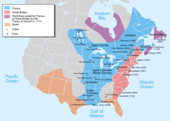
At its peak in 1712 (before the Treaty of Utrecht), the territory of New France extended from Newfoundland to the Rocky Mountains and from Hudson Bay to the Gulf of Mexico. The territory was then divided in five colonies, each with its own administration: Canada, Acadia, Hudson Bay, Newfoundland (Plaisance),[19] and Louisiana.
The Treaty of Utrecht resulted in the relinquishing of French claims to mainland Acadia, the Hudson Bay and Newfoundland colonies, and the establishment of the colony of Île Royale (Cape Breton Island) as the successor to Acadia.[20][21]
Marquette and Jolliet
 Ca. 1681 map of Marquette and Jolliet's 1673 expedition
Many governors of settlements and kings of nations were hoping to be the first to find the Northwest Passage - a shortcut through the New World to the Indies of southeast Asia. The discovery of a Northwest Passage would result in great wealth for the founding nation because it would be able to directly import goods from the Asian markets while controlling the passage itself.
In 1673, the governor of New France (Quebec - the French settlement started by Samuel de Champlain), sent Jacques Marquette, a Catholic priest and missionary, and Louis Jolliet, a French Canadian fur trader, along with seven other explorers, on a mission to find the Northwest Passage. The team began their trip in Quebec and traveled through Michigan's upper peninsula to the northern tip of Lake Michigan. On canoes, they crossed the massive lake and landed at present-day Green Bay, Wisconsin at the mouth of the Fox River. They met native American Indians who described various rivers they would encounter. After portaging their canoes to the Wisconsin River, they entered the Mississippi River on June 17, 1673.[22]
Marquette and Jolliet soon realized that the Mississippi couldn't possibly be the Northwest Passage they were hoping for because it flowed south. Nevertheless, the journey continued. They recorded much of the wildlife they encountered. They described the catfish as a monster with the head of a tiger, the nose of a wildcat, and with whiskers. They encountered herds of buffalo which they described as cattle. The pair rowed south past the junction of the Mississippi River and the Ohio River at present day St. Louis, Missouri, and turned around at the junction of the Mississippi River and Arkansas River. They believed that the Mississippi River flowed into the Gulf of Mexico and were wary of being captured by Spaniards who controlled the area.
The Marquette and Jolliet party returned to Illinois Territory in late 1674, becoming the first Europeans to winter in what would become the city of Chicago. As welcomed guests of the Illinois Confederation, the explorers were feasted en route and fed ceremonial foods such as sagamite.[23]
Upon journey’s end, Father Marquette and Louis Jolliet became the first Europeans to see and map the northern portion of the Mississippi River. Marquette and Jolliet did not discover the Mississippi. American Indians had been using it for thousands of years, and Spanish explorer Hernando de Soto had crossed it more than a century before them. They did confirm, however, that it was possible to travel easily from the Great Lakes all the way to the Gulf of Mexico by water, that the native peoples who lived along the route were generally friendly, and that the natural resources of the lands in between were extraordinary. Equipped with this information, French officials led by LaSalle would erect a 4,000-mile network of trading posts to systematically exploit those riches over the next century and a half.[24]
During the next century, the French established a network of fur trading posts and Jesuit missions along the Mississippi River system and the upper Great Lakes.
British American colonization
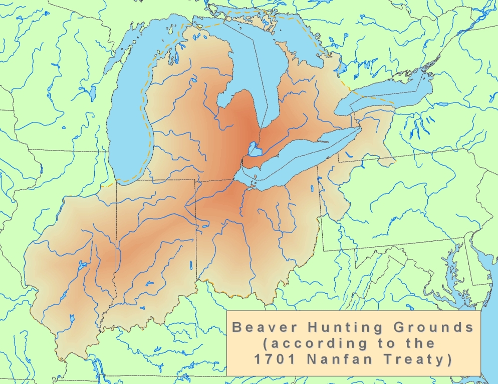
 Early Beaver Hunting Grounds
French control over the area east of the Mississippi River ended in 1763 with the conclusion of the French and Indian War. British colonists began to expand into the Ohio Country during the 1750s. The Royal Proclamation of 1763 temporarily restrained expansion west of the Appalachian Mountains, but did not stop it completely. West of the Mississippi River, French settlers flourished in towns such as St. Louis and Ste. Genevieve until the mid 18th century.
France ceded the rest of New France to Great Britain and Spain at the Treaty of Paris, which ended the Seven Years War (the French and Indian War). Britain received all lands east of the Mississippi River, including Canada, Acadia, and parts of Louisiana, while Spain received the territory to the west – the larger portion of Louisiana. Spain returned its portion of Louisiana to France in 1800, but French leader Napoleon Bonaparte sold it to the United States in the Louisiana Purchase of 1803, permanently ending French colonial efforts on the North American mainland.
British American settlement began either via routes over the Appalachian Mountains, such as Braddock Road, or through the waterways of the Great Lakes. Fort Pitt (now Pittsburgh) at the source of the Ohio River was an early outpost of the overland routes. The first settlements in the Midwest via the waterways of the Great Lakes were centered around military forts and trading posts such as Green Bay, Sault Ste. Marie, and Detroit. The first inland settlements via the overland routes were in southern Ohio or northern Kentucky, on either side of the Ohio River, and early such pioneers included Daniel Boone and Spencer Records.
The region's fertile soil made it possible for farmers to produce abundant harvests of cereal crops such as corn, oats, and, most importantly, wheat. The region soon became known as the nation's "breadbasket".
Development of transportation
Waterways

Two waterways have been important to the development of the Midwest. The first and foremost was the Ohio River, which flowed into the Mississippi River. Development of the region was halted until 1795 due to Spain's control of the southern part of the Mississippi and its refusal to allow the shipment of American crops down the river and into the Atlantic Ocean.
The second waterway is the network of routes within the Great Lakes. The opening of the Erie Canal in 1825 completed an all-water shipping route, more direct than the Mississippi, to New York and the seaport of New York City. In 1848, The Illinois and Michigan Canal breached the continental divide spanning the Chicago Portage and linking the waters of the Great Lakes with those of the Mississippi Valley and the Gulf of Mexico. Lakeport and river cities grew up to handle these new shipping routes. During the Industrial Revolution, the lakes became a conduit for iron ore from the Mesabi Range of Minnesota to steel mills in the Mid-Atlantic States. The Saint Lawrence Seaway (1862, widened 1959) opened the Midwest to the Atlantic Ocean.

In the 1870s and 1880s, the Mississippi River inspired two classic books – Life on the Mississippi and Adventures of Huckleberry Finn – written by native Missourian Samuel Clemens, who used the pseudonym Mark Twain. His stories became staples of Midwestern lore. Twain's hometown of Hannibal, Missouri is a tourist attraction offering a glimpse into the Midwest of his time.
Inland canals in Ohio and Indiana constituted another important waterway, which connected with Great Lakes and Ohio River traffic. The commodities that the Midwest funneled into the Erie Canal down the Ohio River contributed to the wealth of New York City, which overtook Boston and Philadelphia.
Railroads and the automobile
During the mid-19th century the region got its first railroads, and the railroad junction in Chicago grew to be the world's largest. Even today, a century after Henry Ford, six Class I railroads meet in Chicago.
In the period from 1890 to 1930 many Midwestern cities, towns, villages, and even farms were connected by interurbans, or electrical streetcars. The Midwest had more interurbans than any other region.[citation needed] In 1916, Ohio led all states with 2,798 miles (4,503 km), Indiana followed with 1,825 miles (2,937 km). These two states alone had almost a third of the country's interurban trackage.[25] The nation's largest interurban junction was in Indianapolis. During the first decade of the 20th century the city's 38% growth in population was attributed largely to the interurban.[26]
Competition with a growing population of automobiles and buses traveling on paved highways led to a decline in the interurban and other railroad passenger business. Henry Ford and Charles Kettering, the inventor of the electrical starting motor and leaded gasoline, were both products of the Midwest, as were the Wright Brothers.
Civil War
Slavery prohibition and the underground railroad
 Map of various Underground Railroad routes
The Northwest Ordinance region, comprising the heart of the Midwest, was the first large region of the United States that prohibited slavery (the Northeastern United States emancipated slaves in the 1830s). The regional southern boundary was the Ohio River, the border of freedom and slavery in American history and literature (see Uncle Tom's Cabin by Harriet Beecher Stowe and Beloved by Toni Morrison).
The Midwest, particularly Ohio, provided the primary routes for the "Underground Railroad", whereby Midwesterners assisted slaves to freedom from their crossing of the Ohio River through their departure on Lake Erie to Canada. Created in the early 19th century, the Underground Railroad was at its height between 1850 and 1860. One estimate suggests that by 1850, 100,000 slaves had escaped via the "Railroad".[27]
The Underground Railroad consisted of meeting points, secret routes, transportation, and safe houses and assistance provided by abolitionist sympathizers. Individuals were often organized in small, independent groups; this helped to maintain secrecy because individuals knew some connecting "stations" along the route but knew few details of their immediate area. Escaped slaves would move north along the route from one way station to the next. Although the fugitives sometimes traveled on boat or train, they usually traveled on foot or by wagon.[28]
The region was shaped by the relative absence of slavery (except for Missouri), pioneer settlement, education in one-room free public schools, democratic notions brought by American Revolutionary War veterans, Protestant faiths and experimentation, and agricultural wealth transported on the Ohio River riverboats, flatboats, canal boats, and railroads.[citation needed]
Bleeding Kansas
The first violent conflicts leading up to the Civil War occurred between two neighboring Midwestern states, Kansas and Missouri, involving anti-slavery Free-Staters and pro-slavery "Border Ruffian" elements, that took place in the Kansas Territory and the western frontier towns of Missouri roughly between 1854 and 1858. At the heart of the conflict was the question of whether Kansas would enter the Union as a free state or slave state. As such, Bleeding Kansas was a proxy war between Northerners and Southerners over the issue of slavery. The term "Bleeding Kansas" was coined by Horace Greeley of the New York Tribune; the events it encompasses directly presaged the Civil War.
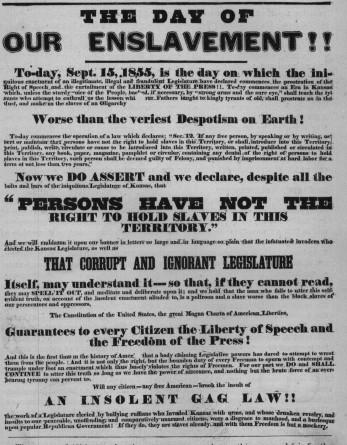
 1855 Free-State poster
Setting in motion the events later known as “Bleeding Kansas’’ was the Kansas-Nebraska Act. The Act created the territories of Kansas and Nebraska, opened new lands that would help settlement in them, repealed the Missouri Compromise, and allowed settlers in those territories to determine through popular sovereignty whether to allow slavery within their boundaries. It was hoped the Act would ease relations between the North and the South, because the South could expand slavery to new territories but the North still had the right to abolish slavery in its states. Instead, opponents denounced the law as a concession to the slave power of the South.
The new Republican Party, born in the Midwest (Ripon, Wisconsin, 1854) and created in opposition to the Act, aimed to stop the expansion of slavery and soon emerged as the dominant force throughout the North.[29]
An ostensibly democratic idea, popular sovereignty stated that the inhabitants of each territory or state should decide whether it would be a free or slave state; however, this resulted in immigration en masse to Kansas by activists from both sides. At one point, Kansas had two separate governments, each with its own constitution, although only one was federally recognized. On January 29, 1861, Kansas was admitted to the Union as a free state, less than three months before the Battle of Fort Sumter officially began the Civil War.[30]
The calm in Kansas was shattered in May 1856 by two events that are often regarded as the opening shots of the Civil War. On May 21, the Free Soil town of Lawrence, Kansas was sacked by an armed pro‐slavery force from Missouri. A few days later, the Sacking of Lawrence led abolitionist John Brown and six of his followers to execute five men along the Pottawatomie Creek in Franklin County, Kansas, in retaliation.[31]
The so-called "Border War" lasted for another four months, from May through October, between armed bands of pro‐slavery and Free Soil men. The U.S. Army had two garrisons in Kansas, the First Cavalry Regiment at Fort Leavenworth and the Second Dragoons and Sixth Infantry at Fort Riley.[32] The skirmishes endured until a new governor, John W. Geary, managed to prevail upon the Missourians to return home in late 1856. A fragile peace followed, but violent outbreaks continued intermittently for several more years.
National reaction to the events in Kansas demonstrated how deeply divided the country had become. The Border Ruffians were widely applauded in the South, even though their actions had cost the lives of numerous people. In the North, the murders committed by Brown and his followers were ignored by most and lauded by a few.[33]
The civil conflict in Kansas was a product of the political fight over slavery. Federal troops were not used to decide a political question, but they were used by successive territorial governors to pacify the territory so that the political question of slavery in Kansas could finally be decided by peaceful, legal, and political means.
 An animation depicting when United States territories and states forbade or allowed slavery, 1789–1861.
The election of Abraham Lincoln in November 1860 was the final trigger for secession by the Southern states.[34] Efforts at compromise, including the "Corwin Amendment" and the "Crittenden Compromise", failed. Southern leaders feared that Lincoln would stop the expansion of slavery and put it on a course toward extinction.
The U.S. federal government was supported by 20 mostly-Northern free states in which slavery already had been abolished, and by five slave states that became known as the border states. All of the Midwestern states but one, Missouri, banned slavery. Though most battles were fought in the South, skirmishes between Kansas and Missouri continued until culmination with the Lawrence Massacre on August 21, 1863. Also known as Quantrill’s Raid, the massacre was a rebel guerrilla attack by Quantrill’s Raiders, led by William Clarke Quantrill, on pro-Union Lawrence, Kansas.
Lawrence was targeted due to the town's long support of abolition and its reputation as a center for Redlegs and Jayhawkers, which were free-state militia and vigilante groups known for attacking and destroying farms and plantations in Missouri’s pro-slavery western counties.
The Lawrence Massacre was one of the bloodiest events in the history of Kansas and the nation. Quantrill’s band of 448 Missouri guerrillas raided and plundered Lawrence, killing more than 150 and burning all the business buildings and most of the dwellings. Pursued by federal troops, the band escaped to Missouri.[35]
General Robert E. Lee surrendered his Army of Northern Virginia on April 9, 1865, at the McLean House in the village of Appomattox Court House.[36]
On April 14, 1865, President Lincoln was shot by John Wilkes Booth, a Southern sympathizer. Lincoln died early the next morning, and Andrew Johnson became president.
Industrialization and immigration
By the time of the American Civil War, European immigrants bypassed the East Coast of the United States to settle directly in the interior: German immigrants to Ohio, Wisconsin, Minnesota, Illinois, and Missouri; Irish immigrants to port cities on the Great Lakes, especially Chicago; Danes, Swedes, and Norwegians to Iowa, Wisconsin, Minnesota, and the Dakotas; and Finns to Upper Michigan and northern/central Minnesota. Poles, Hungarians, and Jews settled in Midwestern cities.
The U.S. was predominantly rural at the time of the Civil War. The Midwest was no exception, dotted with small farms all across the region. The late 19th century saw industrialization, immigration, and urbanization that fed the Industrial Revolution, and the heart of industrial domination and innovation was in the Great Lakes states of the Midwest, which only began its slow decline by the late 20th century.
In the 20th century, African American migration from the Southern United States into the Midwestern states changed Chicago, St. Louis, Cleveland, Milwaukee, Kansas City, Cincinnati, Detroit, Minneapolis, and many other cities in the Midwest dramatically, as factories and schools enticed families by the thousands to new opportunities. Chicago alone gained hundreds of thousands of black citizens from the Great Migration and the Second Great Migration.
History of the term Midwest

The term West was applied to the region in the early years of the country. In 1789, the Northwest Ordinance was enacted, creating the Northwest Territory, which was bounded by the Great Lakes and the Ohio and Mississippi Rivers. Because the Northwest Territory lay between the East Coast and the then-far-West, the states carved out of it were called the "Northwest". In the early 19th century, anything west of the Mississippi River was considered the West. The first recorded use of the term "Midwestern" to refer to a region of the central U.S. occurred in 1886, "Midwest" appeared in 1894, and "Midwesterner" in 1916.[3]
With the settlement of the western prairie, the new term Great Plains States was used for the row of states from North Dakota to Kansas. Later, these states also came to be considered Midwest by some.
The states of the "old Northwest" are now called the "East North Central States" by the United States Census Bureau and the "Great Lakes" region by some of its inhabitants, whereas the states just west of the Mississippi and the Great Plains states are called the "West North Central States" by the Census Bureau. Today people as far west as eastern Colorado, Wyoming, and Montana, sometimes identify themselves with the term Midwest.[37]
Some parts of the Midwest are still referred to as "Northwest" for historical reasons – for example, Northwestern University in Illinois – so the Northwest region of the country is called the "Pacific Northwest" to make a clear distinction.
Farming and agriculture

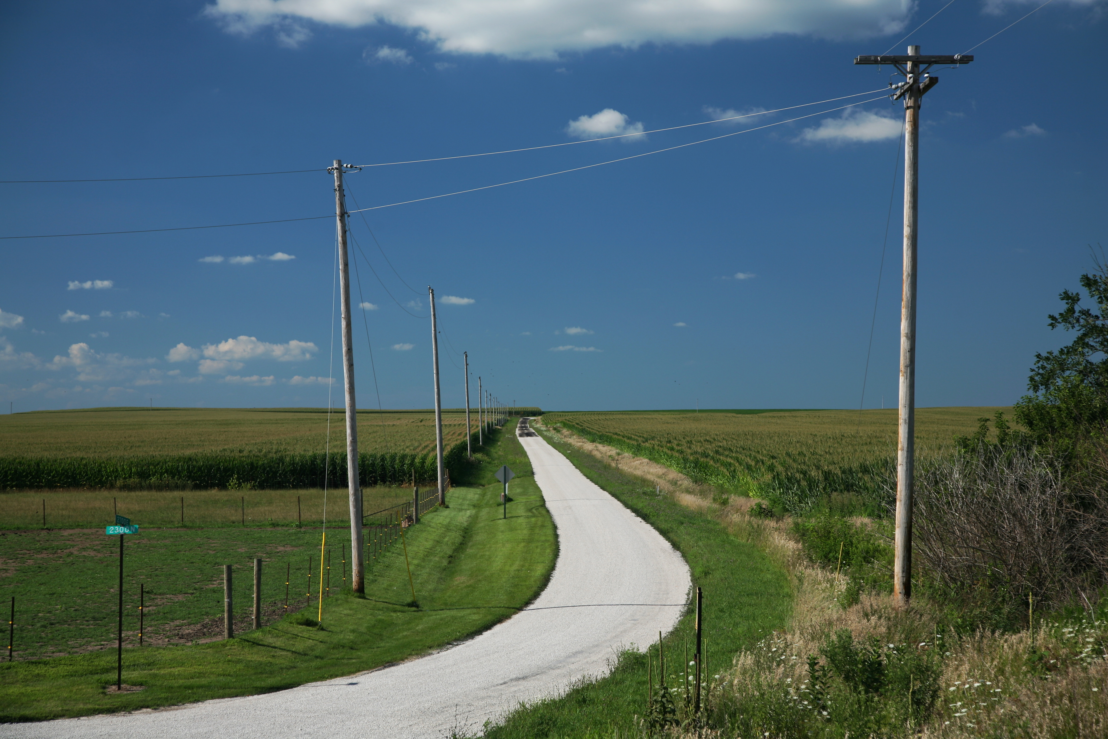
 Rural farm road in Champaign County, Illinois amidst corn fields. Farming covers a large area of the American Midwest.
The very dense soil of the Midwest plagued the first settlers who were using wooden plows, which were more suitable for loose forest soil. On the prairie, the plows bounced around and the soil stuck to them. This problem was solved in 1837 by an Illinois blacksmith named John Deere who developed a steel moldboard plow that was stronger and cut the roots, making the fertile soils of the prairie ready for farming.
The tallgrass prairie has been converted into one of the most intensive crop producing areas in North America. Less than one tenth of one percent (<0.09%) of the original landcover of the tallgrass prairie biome remains.[38] States formerly with landcover in native tallgrass prairie such as Iowa, Illinois, Minnesota, Wisconsin, Nebraska, and Missouri have become valued for their highly productive soils and are included in the Corn Belt. As an example of this land use intensity, Illinois and Iowa rank 49th and 50th out of 50 states in total uncultivated land remaining.
The region’s fertile soil combined with the steel plow has made it possible for farmers to produce abundant harvests of cereal crops, such as corn, wheat, and oats. The region was soon known as the nation’s “breadbasket.”[39]
Religion
Religiously, like most of the United States, the Midwest is predominantly Christian.[citation needed]
Roman Catholicism is the largest religious denomination in the Midwest, varying between 19 and 29% of the state populations.[40] Southern Baptists compose 15.42% of Missouri's population [41] and a small percentage in other Midwestern states. Lutherans are prevalent in the Upper Midwest, especially in Minnesota and the Dakotas with their large Scandinavian and German populations.
Judaism is practiced by 2.5% and Islam is practiced by 1% or less of the population, with higher concentrations in major urban areas. People with no religious affiliation make up 13–16% of the Midwest's population. Surveys show 54% of Midwesterners regularly attend church.[42]
Music
Because of 20th century African American migration from the South, a large African-American urban population lives in most of the region's major cities, although the concentration is not generally as large as that of the Southern United States. The combination of industry and cultures, blues, and rock and roll led to an outpouring of musical creativity in the midwest during the post-Civil Rights movement years, including major contributions to jazz, funk, and R&B, and even new sub-genres such as the Motown Sound and techno from Detroit or house music from Chicago.
Additionally, the electrified Chicago blues sound exemplifies the genre, as popularized by record labels Chess and Alligator and portrayed in such films as The Blues Brothers, Godfathers and Sons, and Adventures in Babysitting.
Rock and roll music was first identified as a new genre in 1951 by Cleveland, Ohio, disc jockey Alan Freed who began playing this music style while popularizing the term "rock and roll" to describe it.[43] By the mid-1950s, rock and roll emerged as a defined musical style in the United States, deriving most directly from the rhythm and blues music of the 1940s, which itself developed from earlier blues, boogie woogie, jazz, and swing music, and was also influenced by gospel, country and western, and traditional folk music.
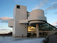
Freed's contribution in identifying rock as a new genre helped establish the Rock and Roll Hall of Fame to be located in Cleveland.
Cultural overlap


Differences in the definition of the Midwest mainly split between the Heartland and the Great Plains on one side, and the Great Lakes and the Rust Belt on the other. While some point to the small towns and agricultural communities in Kansas, Iowa, the Dakotas, and Nebraska of the Great Plains as representative of traditional Midwestern lifestyles and values, others assert that the declining Rust Belt cities of the Great Lakes – with their histories of 19th- and early-20th-century immigration, manufacturing base, and strong Catholic influence – are more representative of the Midwestern experience.
Certain areas of the traditionally defined Midwest are often cited as not being representative of the region, while other areas traditionally outside of the Midwest are often claimed to be part of the Midwest. These claims often embody historical, cultural, economic or demographic arguments for inclusion or exclusion. Perceptions of the proper classification of the Midwest also vary within the region, and tend toward exclusion rather than inclusion.
Two other regions, Appalachia and the Ozark Mountains, overlap geographically with the Midwest – Appalachia in Southern Ohio and the Ozarks in Southern Missouri. The Ohio River has long been the boundary between North and South and between the Midwest and the Upper South. All of the lower Midwestern states, especially Missouri, have a major Southern component, and Missouri was a slave state before the Civil War.
Western Pennsylvania, which contains the cities of Erie and Pittsburgh, plus the Western New York city of Buffalo, share history with the Midwest but overlap with Appalachia and the Northeast as well.[44]
Kentucky is rarely considered part of the Midwest, although it can be grouped with it in some contexts.[45] It is categorized as Southern by the Census Bureau and is usually classified as such, especially from a cultural standpoint.[46][47]
Linguistic characteristics
Main articles: Inland Northern American English, North Central American English, Yooper dialect, and Midland American EnglishThe accents of the region are generally distinct from those of the South and of the urban areas of the American Northeast. To a lesser degree, they are also distinct from the accent of the American West.
The accent characteristic of most of the Midwest is considered by many to be that of "standard" American English or General American. This accent is preferred by many national radio and television broadcasters.[48]
This may have started because many prominent broadcast personalities – such as Walter Cronkite, Harry Reasoner, Johnny Carson, David Letterman, Rush Limbaugh, Tom Brokaw, John Madden, and Casey Kasem – came from this region and so created this perception. A November 1998 National Geographic article attributed the high number of telemarketing firms in Omaha to the "neutral accents" of the area's inhabitants. Currently, many cities in the Great Lakes region are undergoing the Northern cities vowel shift away from the standard pronunciation of vowels.[49]
The dialect of Minnesota, western Wisconsin, much of North Dakota and Michigan's Upper Peninsula is referred to as the Upper Midwestern Dialect (or "Minnesotan"), and has Scandinavian and Canadian[citation needed] influences.
Missouri has elements of three dialects, specifically: Northern Midland, in the extreme northern part of the state; Southern Midland, in the majority of the state, with a distinctive variation in St. Louis and the surrounding area; and Southern, in the southwestern and southeastern parts of the state, with a bulge extending north in the central part, to include approximately the southern one-third.[50]
Major metropolitan areas
Cities Rank City State Population
(2010 census)1 Chicago IL 2,695,598 2 Indianapolis IN 829,718 3 Columbus OH 787,033 4 Detroit MI 713,777 5 Milwaukee WI 594,833 6 Kansas City MO 459,787 7 Omaha NE 408,958 8 Cleveland OH 396,815 9 Minneapolis MN 382,578 10 Wichita KS 382,368 Urban Areas Rank Urban area State(s) Population
(2000 census)1 Chicago IL-IN 8,307,904 2 Detroit MI 3,903,377 3 Minneapolis-
St. PaulMN 2,388,593 4 St. Louis MO-IL 2,077,662 5 Cleveland OH 1,786,647 6 Cincinnati OH-KY-IN 1,503,262 7 Kansas City MO-KS 1,361,744 8 Milwaukee WI 1,308,913 9 Indianapolis IN 1,287,919 10 Columbus OH 1,133,193 Metro Areas Rank Metro area State(s) Population
(2010 census)1 Chicago IL-IN-WI 9,461,105 2 Detroit MI 4,296,250 3 Minneapolis-
St. PaulMN-WI 3,604,460 4 St. Louis MO-IL 2,812,896 5 Cincinnati OH-KY-IN 2,130,151 6 Cleveland OH 2,077,240 7 Kansas City MO-KS 2,035,334 8 Columbus OH 1,836,536 9 Indianapolis IN 1,756,241 10 Milwaukee WI 1,555,908 Politics
Historical
The Midwest has always been a critical region in national elections, with highly contested elections in closely divided states. Especially in the late 19th and early 20th century both parties typically selected either their president or vice president from the region.
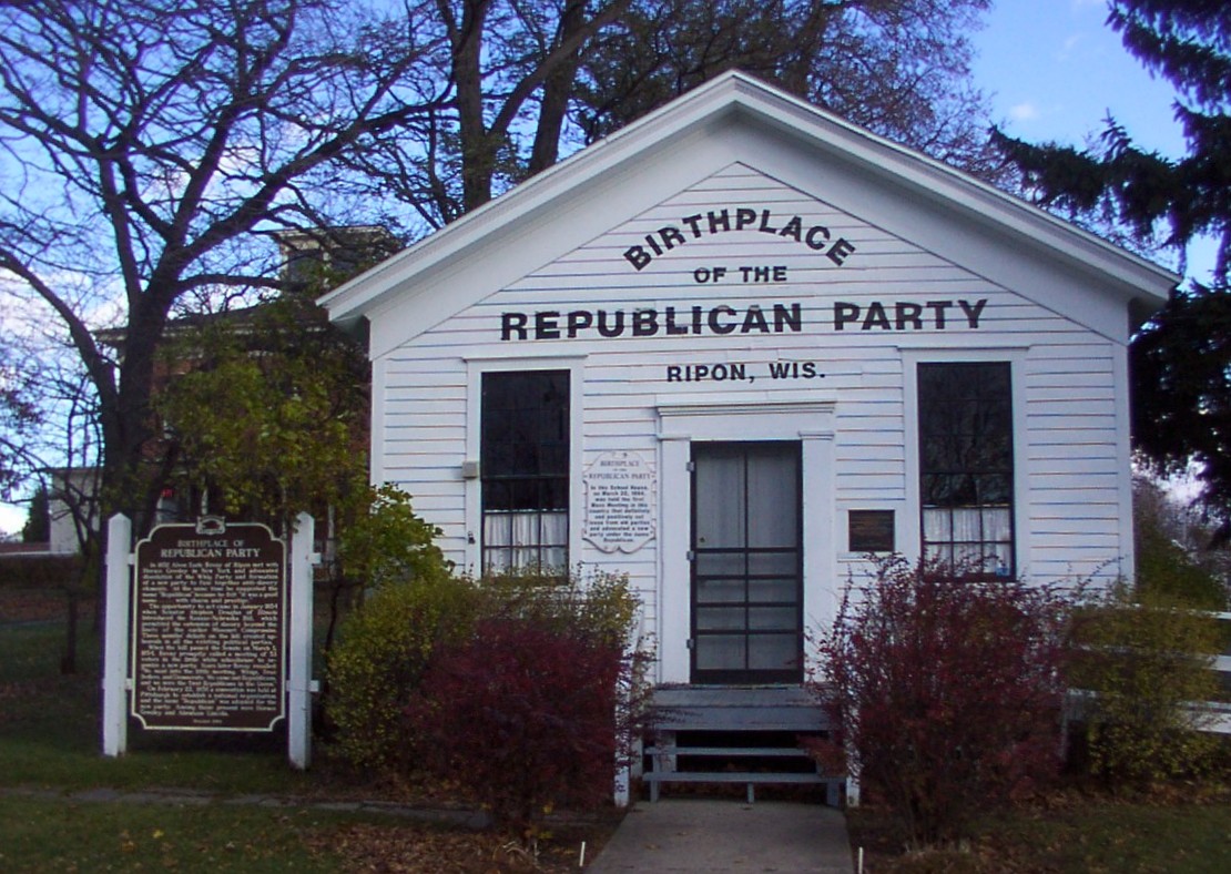
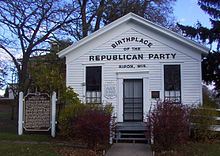 The Little White Schoolhouse of Ripon, Wisconsin is listed on the List of Registered Historic Places.
One of the two major political parties in the United States, the Republican Party, originated in Ripon, in east-central Wisconsin, in the 1850s. It included opposition to the spread of slavery into new states as one of its agendas. The party stressed the Protestant ideals of thrift, hard work ethic, self-reliance, democratic decision making and religious tolerance influenced both parties.
In the early 1890s the wheat-growing regions were strongholds of the Populist movement in the Plains states. It died out after 1896.
Starting in the 1890s the middle class urban Progressive movement became influential in the region (as it was in other regions), with Wisconsin a major center. It fought against corruption and for efficiency, modernization and the use of experts to solve social, economic and political problems. Theodore Roosevelt's 1912 Progressive Party had the best showing in this region; carrying the states of Michigan, Minnesota, and South Dakota. Robert M. La Follette, Sr.'s 1924 Progressive Party also showed a similar trend as he carried his home state of Wisconsin. The Midwest—especially the areas west of Chicago—has always been a stronghold of isolationism, a belief that America should not involve itself in foreign entanglements. This position gained much support from German- and Swedish-American communities, with leaders such as Robert M. La Follette, Sr., Robert A. Taft, and Colonel Robert McCormick, publisher of the Chicago Tribune.[51][52]
Midwestern political caution is sometimes peppered with protest, especially in minority communities or those associated with agrarian, labor, or populist roots. This was especially true in the early 20th century, when Milwaukee was a hub of the Socialist movement in the United States, electing three Socialist mayors and the only Socialist Congressional representative (Victor L. Berger) during that time. The metropolis-strewn Great Lakes region tends to be the most liberal area of the Midwest, and liberal presence diminishes gradually as one moves south and west from that region into the less-populated rural areas.[citation needed] The Great Lakes region has spawned politicians such as the La Follette political family, labor leader and five-time Socialist Party of America presidential candidate Eugene V. Debs, and Communist Party leader Gus Hall. Minnesota has produced liberal national politicians Paul Wellstone, Walter Mondale, Eugene McCarthy, and Hubert Humphrey, and protest musician Bob Dylan.
Recent trends
The region is now home to many critical swing states that do not have strong allegiance to either the Democratic or Republican party. Upper Midwestern states, such as Illinois, Minnesota, Wisconsin, and Michigan tend to vote Democratic, but the 2010 elections proved they can sometimes swing to either party. Indiana is usually considered a Republican stronghold, except in 2008, when the state voted for the Democratic presidential candidate Barack Obama for the first time in 44 years. Prior to the 2008 presidential election, Missouri had supported the winning candidate all but once since the beginning of the 20th century.[citation needed] As a result of the 2010 midterm elections, Republicans now control the governors' office in every Midwestern state, except Illinois, Minnesota, and Missouri. Republicans control every partisan state legislature in the Midwest, except Illinois and the Iowa Senate. (The unicameral Nebraska Legislature is officially nonpartisan.)
The state government of Illinois is currently dominated by the Democratic Party. The state currently has one Republican senator, one Democratic senator, and an 11-8 Republican majority House delegation. Illinois voters have preferred the Democratic presidential candidate by a significantly large margin in the past five elections (1992, 1996, 2000, 2004, 2008).
Iowa is considered by many analysts to be the most evenly divided state in the country, but it has leaned Democratic for the past fifteen years or more. Iowa had a Democratic governor from 1999 until Terry Branstad was re-elected in the mid-term elections in 2010, has had both a Democratic and Republican Senator since the early 1980s, currently has three Democratic Congressmen out of five, and has voted for the Democratic presidential candidate in four out of the last five elections, (1992, 1996, 2000, 2008). As a result of the 2010 elections, Republicans hold a significant majority in the Iowa House of Representatives, while Democrats hold a majority in the Iowa Senate.
Minnesota voters have chosen the Democratic candidate for president longer than any other state. Minnesota was the only U.S. state (along with Washington, D.C.) to vote for Walter Mondale over Ronald Reagan in 1984 (Minnesota is Mondale's home state). In Iowa and Minnesota, however, the recent Democratic pluralities have often been fairly narrow. Minnesota has elected and re-elected a Republican governor, as well as supported some of the strongest gun concealment laws in the nation. As a result of the 2010 elections, Republicans now control both houses of the Minnesota state legislature.
Consistently, Ohio is a battle-ground state in presidential elections - no Republican has won the office without winning Ohio. This trend has contributed to Ohio's reputation as a quintessential swing state. At the state level, however, Republicans are currently dominant. With the exception of one justice of the Supreme Court of Ohio, all statewide elected officials are Republicans, and Republicans have a majority in the Ohio House of Representatives and a supermajority in the Ohio Senate. Ohio has one Democratic and one Republican U.S. Senator. As a result of the 2010 elections, 13 of Ohio's 18 members of the U.S. House of Representatives are Republicans.
The Great Plains states of North Dakota, South Dakota, Nebraska, and Kansas have been strongholds for the Republicans for many decades. These four states have gone for the Republican candidate in every presidential election since 1940, except for Lyndon B. Johnson's landslide over Barry Goldwater in 1964. Although North Dakota and South Dakota have often elected Democrats to Congress, after the 2010 election both states' congressional delegations are majority Republicans. Nebraska has elected Democrats to the Senate and as Governor in recent years, but the state's House delegation has been all-Republican since 1995. Kansas has elected a majority of Democrats as governor since 1956 but has not elected a Democrat to the Senate since 1932. Both of Kansas's U.S. Seantors and all four of its U.S. House members are Republican.
Missouri is considered a "bellwether state". Only twice since 1904 has the Show-Me-State not voted for the winner in the presidential election, in 1956 and in 2008, when the state broke for Republican John McCain. Missouri's House delegation has generally been evenly divided between Democrats and Republicans, with the Democrats holding sway in the large cities at the opposite ends of the state, Kansas City and St. Louis, and the Republicans controlling the rest of the state. However, as a result of the 2010 elections, Republicans now have a 6-3 majority in the state's House delegation. Missouri's Senate seats were mostly controlled by Democrats until the latter part of the 20th century, but the Republicans have held one or both Senate seats continuously since the 1976 elections.
Iowa caucuses
Main article: Iowa CaucusesThe Iowa caucuses are an electoral event in which residents of Iowa meet in precinct caucuses in all of the state's 1,784 precincts and elect delegates to the corresponding county conventions. There are 99 counties in Iowa and thus 99 conventions. These county conventions then select delegates for both Iowa's Congressional District Convention and the State Convention, which eventually choose the delegates for the presidential nominating conventions (the national conventions). The 2012 Iowa Caucuses are scheduled to take place on February 6, 2012.[53]
The caucuses are noteworthy for the amount of media attention they receive during U.S. presidential election years. Since 1972, the Iowa caucuses have been the first major electoral event of the nominating process for President of the United States. Although only about one percent of the nation's delegates are chosen by the Iowa State Convention, the Iowa caucuses have served as an early indication of which candidates for president might win the nomination of their political party at that party's national convention.
The Iowa caucuses are commonly recognized as the first step in the U.S. presidential nomination process for both the Democratic and the Republican Parties.
See also
Notes
- ^ http://www.census.gov/geo/www/us_regdiv.pdf
- ^ Population in Metropolitan and Micropolitan Statistical Areas Ranked by 2000 Population for the United States and Puerto Rico: 1990 and 2000 (pdf). U.S. Census Bureau. December 30, 2003. Retrieved November 20, 2007.
- ^ a b Oxford English Dictionary entries for "Midwestern", "Midwest", and "Midwesterner", http://www.oed.com/
- ^ Examples of the use of "Middle West" include: Turner, Frederick Jackson (1921). The Frontier in American History. H. Holt and Company. OCLC 2127640. http://books.google.com/books?id=vtF1AAAAMAAJ. Shortridge, James R. (1989). Middle West: Its Meaning in American Culture. University Press of Kansas. ISBN 9780700604753. http://books.google.com/books?id=-pUOAAAACAAJ. Bradway, Becky (2003). In the Middle of the Middle West: Literary Nonfiction from the Heartland. Indiana University Press. ISBN 9780253216571. http://books.google.com/books?id=yuq2ZNXLvAIC. and Gjerde, Jon (1999). The Minds of the West: Ethnocultural Evolution in the Rural Middle West, 1830-1917. UNC Press. ISBN 9780807848074. http://books.google.com/books?id=qDxRsvJ0zeUC.; among many others.
- ^ Merriam-Webster online
- ^ Sisson (2006) pp 69-73; Richard Jensen, "The Lynds Revisited," Indiana Magazine of History (Dec 1979) 75: 303-319, online at [1]
- ^ "Consulate General of Iceland New York Culture". Consulate General of Iceland New York. http://www.iceland.is/iceland-abroad/us/nyc/cultural-affairs/. Retrieved June 27, 2011.
- ^ "Bureau of Labor Statistics". Stats.bls.gov. 2010-03-04. http://stats.bls.gov/news.release/srgune.t02.htm. Retrieved 2010-10-03.
- ^ a b "Remote Sensing Tutorial, Section 6, online". http://rst.gsfc.nasa.gov/Sect6/Sect6_4.html. Retrieved 2011-06-09.
- ^ [2]| Midwestern Literature: Indian American Culture in the Midwest prior to the Arrival of Europeans. Retrieved 2011-6-17.
- ^ Official National Park Service website: [3] Retrieved 2011-6-24.
- ^ [4]|Indian Country Wisconsin. Great Lakes History: A General View.
- ^ [5] Midwestern Literature: Indian American Culture in the Midwest prior to the Arrival of Europeans. Retrieved 2011-5-17.
- ^ Hamalainen, Pekka (2008). The Comanche Empire. Yale University Press. pp. 37–38. ISBN 978-0-300-12654-9.
- ^ [6]|Native Net: The Sioux Indians were a Great and Powerful Tribe. Online.
- ^ Hamalainen, 20–21
- ^ For a report on the long-established blunder of misnaming as “Nakota”, the Yankton and the Yanktonai, see the article Nakota
- ^ Ullrich, Jan (2008). New Lakota Dictionary (Incorporating the Dakota Dialects of Yankton-Yanktonai and Santee-Sisseton). Lakota Language Consortium. pp. 1–2. ISBN 0-9761082-9-1.
- ^ "The French Settlement of Placentia: Newfoundland and Labrador Heritage". Heritage Canada. http://www.heritage.nf.ca/exploration/french.html. Retrieved 2010-06-30.
- ^ Control and Order in French Colonial Louisbourg, 1713-1758, Andrew John Bayly Johnston, 2001, MSU Press pp. 8-9 [7]
- ^ "Archaeology Program 2010". Fortressoflouisbourg.ca. http://www.fortressoflouisbourg.ca/ArchaeologyE/SiteInformation.html#HistoryFortress. Retrieved 2010-06-30.
- ^ [8]|Mr. Nussbaum – Marquette and Jolliet online. Retrieved 2011-6-17.
- ^ [9]|Wisconsin Historical Society Archives online. Retrieved 2011-6-17.
- ^ [10] Wisconsin Historical Society –Marquette and Jolliet.
- ^ "US History Encyclopedia: Interurban Railways". Answers.com. http://www.answers.com/topic/railways-interurban. Retrieved 2010-10-03.
- ^ David P. Morgan (ed.): The Interurban Era, Kalmbach Publishing Co., pp. 16-17.
- ^ The Fugitive Slave Law African-American History, pp. 1–2. About.com
- ^ Bordewich, Fergus, 2005,p. 236
- ^ http://www.masslive.com/history/index.ssf/2011/05/springfields_375th_from_puritans_to_presidents.html#incart_hbx
- ^ Robert W. Johansson, Stephen A. Douglas (Oxford UP, 1973) pp374-400
- ^ [11]|Africans in America Resource Bank: People and Events, 1853-1861, online. Retrieved June 14, 2011.
- ^ [12]|Gale Encyclopedia of U.S. History: Pottawatomie Massacre. Answers.com. Retrieved June 14, 2011
- ^ [13] United States History – Bleeding Kansas online. Retrieved June 14, 2011.
- ^ David Potter, The Impending Crisis, p. 485.
- ^ [14]|”Quantrill’s Raid” Answers.com. Retrieved June 14, 2011.
- ^ William Marvel, Lee's Last Retreat: The Flight to Appomattox (2002) pp 158–81
- ^ Sisson (2006) pp 57-60
- ^ Carl Kurtz. Iowa's Wild Places: An Exploration With Carl Kurtz (Iowa Heritage Collection) Iowa State Press; 1st edition (July 30, 1996)
- ^ [15]|The U.S. Department of State Fact Monster. Retrieved 2011-6-2.
- ^ Philip Barlow and Mark Silk, Religion and public life in the midwest: America's common denominator? (2004)
- ^ "Southern Baptist Convention statistics". Adherents.com. http://www.adherents.com/largecom/com_sbc.html. Retrieved 2010-10-03.
- ^ See [http://web.archive.org/web/20080716071802/http://www.barna.org/FlexPage.aspx?Page=Topic&TopicID=10 Barna Research, "Church Attendance"
- ^ Bordowitz, Hank (2004). Turning Points in Rock and Roll. New York, New York: Citadel Press. p. 63. ISBN 978-0-80652-631-7.
- ^ Defining the Midwest Megaregion
- ^ The North American Midwest: A Regional Geography. New York City: Wiley Publishers. 1955.
- ^ "Welcome to Travel South USA". Travelsouthusa.org. http://www.travelsouthusa.org/states.html. Retrieved 2010-10-03.
- ^ "Encyclopedia - Britannica Online Encyclopedia". Britannica.com. http://www.britannica.com/EBchecked/topic-art/315026/3822/The-Upper-South. Retrieved 2010-10-03.
- ^ Gewertz, Ken (12 December 2002). "Standing on line at the bubbler with a hoagie in my hand". Harvard Gazette. http://www.news.harvard.edu/gazette/2002/12.12/08-vaux.html. Retrieved 11 August 2010.
- ^ "Northern Cities Shift". Ic.arizona.edu. http://www.ic.arizona.edu/~lsp/Northeast/ncshift/ncshift.html. Retrieved 2010-10-03.
- ^ Lavov,William et alia|A National Map of the Regional Dialects of American English|http://www.ling.upenn.edu/phone_atlas/NationalMap/NationalMap.html#Heading2%7CLinguistics Laboratory, Department of Linguistics, University of Pennsylvania|05/15/2010
- ^ Ralph H. Smuckler, "The Region of Isolationism," American Political Science Review, Vol. 47, No. 2 (Jun., 1953), pp. 386-401 in JSTOR
- ^ John N. Schacht, Three Faces of Midwestern Isolationism: Gerald P. Nye, Robert E. Wood, John L. Lewis (1981).
- ^ http://race42012.com/2010/11/10/2012-primary-calendar-early-states-edition/
References
- Barlow, Philip, and Mark Silk. Religion and Public Life in the Midwest: America's Common Denominator? (2004)
- Buley, R. Carlyle. The Old Northwest: Pioneer Period 1815-1840 2 vol (1951), Pulitzer Prize
- Cayton, Andrew R. L. Midwest and the Nation (1990)
- Cayton, Andrew R. L. and Susan E. Gray, Eds. The American Midwest: Essays on Regional History. (2001)
- Cronon, William. Nature's Metropolis: Chicago and the Great West (1992), 1850-1900 excerpt and text search
- Garland, John H. The North American Midwest: A Regional Geography (1955)
- Gjerde, John. Minds of the West: Ethnocultural Evolution in the Rural Middle West, 1830-1917 (1999) excerpt and text search
- Jensen, Richard. The Winning of the Midwest: Social and Political Conflict, 1888-1896 (1971) online free
- Meyer, David R. "Midwestern Industrialization and the American Manufacturing Belt in the Nineteenth Century", The Journal of Economic History, Vol. 49, No. 4 (Dec., 1989) pp. 921–937.in JSTOR
- Nordin, Dennis S., and Roy V. Scott. From Prairie Farmer to Entrepreneur: The Transformation of Midwestern Agriculture. (2005) 356pp.
- Shannon, "Fred A. The Status of the Midwestern Farmer in 1900". The Mississippi Valley Historical Review. Vol. 37, No. 3. (Dec., 1950), pp. 491–510. in JSTOR
- Sisson, Richard, Christian Zacher, and Andrew Cayton, eds. The American Midwest: An Interpretive Encyclopedia (Indiana University Press, 2006), 1916 pp of articles by scholars on all topics covering the 12 states; ISBN 0-253-34886-2 ISBN 978-0-253-34886-9
- Slade, Joseph W. and Judith Lee. The Midwest: The Greenwood Encyclopedia of American Regional Cultures (2004)
- Wuthnow, Robert. Remaking the Heartland: Middle America Since the 1950s (Princeton University Press; 2011) 358 pages
Further reading
- Frederick; John T. ed. Out of the Midwest: A Collection of Present-Day Writing (1944) literary excerpts online edition
United States (Outline) History Pre-Columbian era · Colonial era (Thirteen Colonies · Colonial American military history) · American Revolution (War) · Federalist Era · War of 1812 · Territorial acquisitions · Territorial evolution · Mexican–American War · Civil War · Reconstruction era · Indian Wars · Gilded Age · African-American Civil Rights Movement (1896–1954) · Spanish–American War · Imperialism · World War I · Roaring Twenties · Great Depression · World War II (Home front) · Cold War · Korean War · Space Race · African-American Civil Rights Movement (1955–1968) · Feminist Movement · Vietnam War · Post-Cold War (1991–present) · War on Terror (War in Afghanistan · Iraq War) · Timeline of modern American conservatismTopicsDemographic · Discoveries · Economic (Debt Ceiling) · Inventions (before 1890 · 1890–1945 · 1946–1991 · after 1991) · Military · Postal · Technological and industrialFederal
governmentLegislature - Congress
Senate
· Vice President
· President pro tem
House of Representatives
· Speaker
Judiciary - Supreme Court
Federal courts
Courts of appeal
District courtsExecutive - President
Executive Office
Cabinet / Executive departments
Civil service
Independent agencies
Law enforcement
Public policy
Intelligence
Central Intelligence Agency
Defense Intelligence Agency
National Security Agency
Federal Bureau of InvestigationPolitics Divisions · Elections (Electoral College) · Foreign policy · Foreign relations · Ideologies · Local governments · Parties (Democratic Party · Republican Party · Third parties) · Political status of Puerto Rico · Red states and blue states · Scandals · State governments · Uncle SamGeography Cities, towns, and villages · Counties · Extreme points · Islands · Mountains (Peaks · Appalachian · Rocky) · National Park System · Regions (Great Plains · Mid-Atlantic · Midwestern · New England · Northwestern · Southern · Southwestern · Pacific · Western) · Rivers (Colorado · Columbia · Mississippi · Missouri · Ohio · Rio Grande) · States · Territory · Water supply and sanitationEconomy Agriculture · Banking · Communications · Companies · Dollar · Energy · Federal Budget · Federal Reserve System · Financial position · Insurance · Mining · Public debt · Taxation · Tourism · Trade · Transportation · Wall StreetSociety TopicsCrime · Demographics · Education · Family structure · Health care · Health insurance · Incarceration · Languages (American English · Spanish · French) · Media · People · Public holidays · Religion · SportsArchitecture · Art · Cinema · Cuisine · Dance · Fashion · Flag · Folklore · Literature · Music · Philosophy · Radio · Television · TheaterIssues Book ·
  Category ·
  Portal ·
  WikiProjectCategories:
- Midwestern United States
- Regions of the United States
- Census regions of the United States


Wikimedia Foundation. 2010.