- Nawabshah
-
Nawabshah
نوابشاہ— City — Nawab Shah 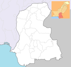
 Nawabshah
Coordinates: 26°09′N 68°15′E / 26.15°N 68.25°E Country  Pakistan
Province  Sindh
SindhDistrict Shaheed Benazirabad Government - Deputy commissioner Jamal Mustafa Sayed Area - Total 4,239 km2 (1,636.7 sq mi) Time zone PST (UTC+5) Number of Talukas 4 Number of Union councils 51 Nawabshah (Urdu, Sindhi: نوابشاہ), or Shaheed Benazirabad, is a district in the Sindh province of Pakistan. It is headquarter of Shaheed Benazir Abad District (formerly Nawabshah District). It has a population of 1,135,131.[1][2]
Contents
Location
By road it is a 4 hours drive from Karachi to National Highway, Sakrand along the left bank of River Indus near Sakrand Taluka, Pakistan.
Administration
Nawabshah formerly formed part of Sukkur division. Deputy commissioner is responsible for overall administration of the District. Furthermore Nawabshah is sub-divided into 4 Talukas from the administrative point of view.
- Nawabashah
- Sakrand
- Daur
- Daulatpur
- Kazi Ahmed
Area and Population
Area 4,239 Square KM Population 11,35,131 Male 5,99,275 Female 5,35,856 Literacy rate(male/female) 34.13% Population (below 15 Years) 45% Population (between 15-65 Years) 52.2% Population (above 65 Years) 2.8% Population Growth Rate 3.09% Geography
Nawabshah is famous for sugarcane Mango and banana production. The climate is usually very hot and dry, with summer temperatures soaring as high as 53 degrees Celsius. Winters start late, around mid-November, lasting to around mid-February, with night-time temperatures often reaching 4 degrees Celsius. Temperatures below zero are very rare. The city is one of Pakistan's hottest areas.
Climate
Main article: Climate of NawabshahThe highest temperatures each year in Pakistan, typically rising to above 50 °C (122 °F), are usually recorded in Nawabshah District and Sibbi from May to August. The climate is generally dry and hot, but sometimes the temperature falls to 0 °C (32 °F). On January 7, 2011 temperatures dropped to 4 °C (39 °F) in the city.[4]
Azadari in Nawabshah
Nawabshah have a great population of Akhbari Shia Muslims . The oldest and central Imambargah is Imambargah Murtazvi sited at Mohni Bazar Nawabshah . Every year all Shia procession with a giant group of Shia followers are start procession on the street from Mohni Bazar Imambargah Murtazvi to Imambargah ( Isrepura) , Hussainia Sajjadia Imambargah ( Jam Saheb Road ) and return to start point Murtazvi Imambargah Nawabshah.((cn}}
Main Imambargah's of Nawabshah
- Markazi Murtazvi Imambargah - Mohni Bazar - Owned by Faqeer Syed Nasir Hussain
- Hussainia Sajjadia Imambargah - Jam Saheb Road - Owned by Syed Kazim Raza
- Mabdah-ul-Uloom Imambargah - Isrepura - Owned by Syed Shakir Shah
Matami Anjuman's
- Sangat Dar-e-Zahra
- Sangat Bawa Buddu Shah
- Sangat Wafa-e-Abbass
Demographics
Religions
- Islam: 78.53%
- Hinduism: 17.88%
- Christianity: 2.33%
- Ahmaddiya: 0.23%
- Others: 1.26%
Languages
Archeology
The mausoleum of Thul Mir Rukun is historical and archeological tomb is situated at 15 kilometers away from Daulatpur (Town). A road from Kazi Ahmed Town via Pabjo village leads to Thul Rukan to reach this thousand years old archeological construction. The height of this tomb is 60 feet from ground level. Mr. Henry Cusin, the British Archeologist writes in his book "Sindh's Archeology" (Sindhi Translation "Sindh Ja Qadeem Aasaar" by Ata Muhammad Bhambro) that the bricks used in the construction of this tomb were made and prepared of Budhist Rulers' period. The line painting for the birth of Gaotam Budh was shown on the bricks clearly which are preserved and kept by the Sindh Archeological Department. He writes that the ornaments and small effigies and statues were also found when the ground was dug around the tomb. Chaheen Jo Daro is historical and archaeological pleas it is near village Jamalkeerio Rohri canal.
Communications
a) Railway
(i) Main Railway line, Lahore to Karachi.
(ii) Meter Gauge Line, Nawabshah to Mirpurkhas.
(iii) Feeder Lines, Padidan, Mahrabpur,
via Tharushah to Sakrand Nawabshah and Sakrand to Tando Adam Via Hala (entire lines abundant).
b) Roads.
(i) N-5 National Highway passing through Sakrand and Daulatpur Talukas.
(ii) Nawabshah Sakrand Road.
(iii) Nawabshah Kazi Ahmed Road.
(iv) Nawabshah—Sanghar Road.
(v) Nawabshah Kumb via Bandhi and Daur.
(vi) Nawabshah 60th Mile and Military Chaks.
(vii) Nawabshah Jam Sahib.
(viii) Desert area road, Jam Sahib - Preetamabad District Sanghar.
(ix) Moro Bandhi Road.
(x) Other link roads connecting Taluka / District Head Quarters and others town.
c) Airway. Nawabshah is connected to others parts of the country as well the rest of the world through airways too. Nawabshah Airport serves the purpose. Nawabshah Airport is based on Old (RAF) Royal Air Force WW2 base which is currently being used for commuter flights by PIA and other local airline services. It is also an alternate to Karachi International Airport. It provides sending facilities for aircraft at this Airport in case of necessary or diversion. Nowadays you can also book local flights from Nawabshah, to Islamabad and Karachi.
Industry
(i) Habib Sugar Mills Ltd Nawabshah
(ii) Chemi Visco Lint Cotton Factory NawabshahChemi ViscoThere are various educational institutions in the city, these include:
- Quaid-e-Awam University of Engineering, Science and Technology, Nawabshah [QUEST]
- Peoples University of Medical and Health Sciences (former Peoples Medical College for Girls, Nawabshah)
- The City School, Senior Branch, Society Nawabshah
- Govt. Habib College of Technology, Nawabshah
- Govt. Degree (Boys) College, Nawabshah
- Govt. Degree (Girls) College, Nawabshah
- Govt. Sachal Sarmast College, Nawabshah
- Govt. Shaheen Vocational Institute Nawabshah ( for boys technical training in Electrics , Mechanical and Auto Mechanic skills)
- Govt. Science College, Sakrand
- Mono Technical Institute, Sakrand
- Agriculture Training Institute, Sakrand
- Govt. College, Daur
- SZABIST College, Nawabshah
- Keep Straight Academy of English Language, Nawabshah
- Rangers Public School & College, Nawabshah
- Crown College of Commerce, Nawabshah
- IMPERIAL Science College Sakrand Road Nawabshah
- Noor Eastern Collegiate, Nawabshah
- Provincial Institute for Teachers Education
- Women Vocational Institute
- Govt. Technical College
- Govt. Municipal Higher Secondary School (Providing Secondary School Education)
- Govt. Naya Madarsa High School, Nawabshah
- British English Language Centre, Nawabshah
- Faraz Model High School Nawabshah
- The Educators School
- Air Foundation Public School
- Gulshan Public High School
- Quiad e Awam University High School
Sports
Nawabshah has a stadium called Bilawal Sports Stadium For National Level Cricket Matches. Nearly all domestic first class matches are held at this stadium.[citation needed] keep straight academy of English language near Shoaib Medical Centre Shaheed Benazir Bhutto University.
Events
The H.M KHOJA Annual Flower Show was introduced by H.M Khoja in the year 1954 at Khoja Garden. The event is celebrated for 3 to 4 days. The event was first organised under the chairship of Madem Faryal Talpur in first tenure Of district Nazim Nawabshah and was organised By Khalid hussain Channa Distt: Naib Nazim e Ala'a ,and D.C.O Nawabshah.
Major educational institutions
- Peoples University of Medical and Health Sciences.
- Quaid-e-Awam University of Engineering, Sciences & Technology
- The City School, Senior Branch, Nawabshah
- Government Habib College of Technology,
- Vocational Institute
- Provincial Institute of Teachers Education
- Bilawal Institute of Historical and Research
Organizations
- Nawabshah Press Club
- Nawabshah Disability Forum
- Rakaposhi Hiking Club
- Rotary Club
- Help Welfare Organization (HWO)
- Services for Mankind Organization SMO
- Sachal Sarmast Special Education
- Shah Sachal Sami Welfare Association
- Sindhica Reforms Society
- Hari Welfare Association
- Public Welfare Society Sindh
- Al-Ajal Scout NawabShah
- Society for Education Promotion & Rural Support SEPRS
- Nawabshah Youth Organization (NYO)
- WWF-PAK Indus for All
- [[Thallaseamia Child Care Center NawabshahThallaseamia Child Care Center Nawabshah - Facebook page]] (TCC)
Political personalities
- Hakim Ali Zardari
- Asif Ali Zardari
- Faryal Talpur
- Abdul Rauf Khan
- Syed Kazim Hussain Shah
- Syed Faseeh Shah - MPA Sindh Provincial Assembly
- Chaudhary Tariq Masood Arain - MPA Sindh Provincial Assembly
References
- ^ http://www.sindh.gov.pk/dpt/PopulationDev/nawabshah.htm
- ^ http://world-gazetteer.com/wg.php?x=&men=gpro&lng=en&des=wg&geo=-172&srt=pnan&col=abcdefghinoq&msz=1500&pt=c&va=&geo=418488840
- ^ http://www.sindh.gov.pk/dpt/PopulationDev/nawabshah.htm
- ^ "Mercury dips to 4°C in Nawabshah | Latest news, Breaking news, Pakistan News, World news, business, sport and multimedia". Dawn.Com. 2010-10-13. http://www.dawn.com/2011/01/06/mercury-dips-to-4c-in-nawabshah.html. Retrieved 2011-01-07.
External links
- Government Shaheed Benazir Abad Education & Literacy Department Official Website
- Nawabshah Disability Forum Official Website
- Nawabshah travel guide from Wikitravel
- Government Shaheed Benazir Abad Official Website under construction
- Quaid-e-Awam University of Engineering Science & Technology
- Peoples' Medical College
Major cities in Pakistan Islamabad Capital Territory Punjab Attock · Bahawalpur · Chakwal · Chiniot · Faisalabad · Gujar Khan · Gujranwala · Gujrat · Jhang · Jhelum · Kasur · Kharian · Lahore** · Mianwali · Multan · Murree · Rahim Yar Khan · Rawalpindi · Sadiqabad · Sahiwal · Sargodha · Sheikhupura · Sialkot · TaxilaSindh Khyber Pakhtunkhwa Balochistan Azad Kashmir Gilgit-Baltistan *Federal capital **Provincial/Territorial capitalsCategories:- Populated places in Sindh


Wikimedia Foundation. 2010.