- Renmark Paringa Council
-
Renmark Paringa Council
South Australia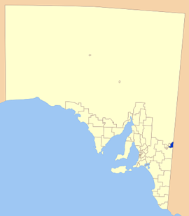
Location of the Renmark Paringa CouncilPopulation: 9,882(2009)[1] Established: 1996 Area: 915.5 km² (353.5 sq mi) Mayor: Neil Martinson Council Seat: Renmark Region: The Riverland State District: Chaffey Federal Division: Wakefield 
LGAs around Renmark Paringa Council: Outback Areas Community Development Trust Berri Barmera Council Renmark Paringa Council Mildura (Vic) District Council of Loxton Waikerie The Renmark Paringa Council is a local government area located adjacent to the Victorian border, in the Riverland, South Australia. The area is known for its various fruit production, and is heavily dependent on the River Murray as a water source.
Contents
History
As with most regions of Australia, the earliest inhabitants of the district area were the Naralte aboriginal people, who lived on the food provided by the river and surrounding areas. The word 'Renmark' is thought to be derived from the Naralte word for 'red mud'.[2]
The first European to explore the district was Captain Charles Sturt who rowed a whale boat down the Murrumbidgee in 1829, searching for Australia's 'inland sea' and reached the junction with the Murray River on 14 January 1830.
The Canadian Chaffey brothers are honoured as founders of Renmark, and were invited to Australia to create an irrigation colony at Mildura. After delays in the Mildura project, an agreement for the establishment of an irrigation colony at Renmark was signed in 1887. Vineyards and fruit blocks slowly emerged throughout the district, sealing the fate of the district as a fruit and wine growing region.
In 1893, the ‘Renmark Irrigation Trust’ was established to provide water to the growers. In the early years, the Trust also played the primary role in the administration and governing of the settlement.[2]
The 'Town of Renmark' and the 'District Council of Paringa' were established not long after, and continued operating independently until 1996, when the two districts amalgamated to form the current council.[3]
Economy
The towns in the district are heavily reliant on irrigated orchards and vineyards, with water supplied by the river. Sheep grazing and dryland farming of various cereal crops are the main land uses east of the river, with farming and horticulture to the west of the river.[3]
While wine grape production is the most important industry, there are also large nut and citrus plantations in the region, as well as vegetable and stone fruit production.[4]
Tourism is an important component of the economy, especially during summer school holidays. The district experiences in an influx of tourists during this period, attracted mainly by the River Murray. Houseboats are common along the stretch of river in the district, with other water sports such as water skiing, jet skiing and fishing common. There is a wide range of accommodation in the district.[4]
Localities
Renmark and Paringa are the largest towns and the centres of the district, with a number of smaller localities encompassed in the district. The full list is:
Calperum, Chaffey, Cooltong, Gurra Gurra, Lock No. 5, Lock No. 6, Lyrup, Murtho, Paringa, Pike River, Renmark, Renmark South, Renmark West and Wonuarra.[5]
Elected Members
Mayor: Neil Martinson
CEO: Barry Hurst
Councillors:
- Louis Dimou
- Paul Campbell
- Graeme Daniel
- Tony Hersey
- Neville Nattrass
- Terry Petersen
- Maria Spano
- Bob Twyford
References
- ^ Australian Bureau of Statistics (30 March 2010). "Regional Population Growth, Australia, 2008–09". http://www.abs.gov.au/ausstats/abs@.nsf/Latestproducts/3218.0Main%20Features72008-09?opendocument&tabname=Summary&prodno=3218.0&issue=2008-09&num=&view=. Retrieved 3 June 2010.
- ^ a b Renmark Paringa Council, Strategic Plan, http://www.renmarkparinga.sa.gov.au/site/page.cfm?u=199, retrieved 2007-05-02
- ^ a b Planning SA, Development Plan, http://www.planning.sa.gov.au/edp/pdf/repa.pdf, retrieved 2007-05-02
- ^ a b Renmark Paringa Council, Council Profile, http://www.renmarkparinga.sa.gov.au/site/page.cfm?u=101, retrieved 2007-05-02
- ^ Local Government Association of South Australia, Renmark Paringa Council, http://www.lga.sa.gov.au/site/page.cfm?c=4192, retrieved 2007-05-02
External links
Local Government Areas of South Australia Metropolitan Adelaide Adelaide · Adelaide Hills · Burnside · Campbelltown · Charles Sturt · Gawler · Holdfast Bay · Marion · Mitcham · Norwood Payneham & St Peters · Onkaparinga · Playford · Port Adelaide Enfield · Prospect · Salisbury · Tea Tree Gully · Unley · Walkerville · West TorrensEyre Peninsula Ceduna · Cleve · Elliston · Franklin Harbour · Kimba · Lower Eyre Peninsula · Port Augusta · Port Lincoln · Streaky Bay · Tumby Bay · Wudinna · WhyallaCentral Barossa · Barunga West · Clare and Gilbert Valleys · Copper Coast · Flinders Ranges · Goyder · Light · Mallala · Mount Remarkable · Northern Areas · Orroroo Carieton · Peterborough · Port Pirie · Wakefield · Yorke PeninsulaSouthern and Hills Murray Mallee Berri Barmera · The Coorong · Gerard · Karoonda East Murray · Loxton Waikerie · Mid Murray · Murray Bridge · Renmark Paringa · Southern MalleeSoutheast Outback Coordinates: 34°10′12″S 140°44′56″E / 34.17°S 140.748888889°E
Categories:- Populated places established in 1996
- 1996 establishments in Australia
- Local Government Areas of South Australia
- Riverland

Wikimedia Foundation. 2010.