- Melbourn
-
For other uses, see Melbourne (disambiguation).
Coordinates: 52°04′55″N 0°01′14″E / 52.081975°N 0.020516°E
Melbourn 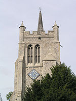
 Melbourn
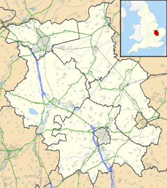
Melbourn shown within CambridgeshirePopulation 4,414 [1] OS grid reference TL385445 District South Cambridgeshire Shire county Cambridgeshire Region East Country England Sovereign state United Kingdom Post town ROYSTON Postcode district SG8 Dialling code 01763 Police Cambridgeshire Fire Cambridgeshire Ambulance East of England EU Parliament East of England List of places: UK • England • Cambridgeshire Melbourn is a large village in the far south west of Cambridgeshire, England. It is located next to the A10 just north of Royston. Melbourn has over 4,400 inhabitants. Melbourn is located in the South Cambridgeshire District, but is served by the Royston, Hertfordshire post town.
The Prime Meridian passes to the west of Melbourn.
Contents
History
The parish has a long history of occupation, stemming from the presence of springs at Melbourn Bury and the several ancient trackways that cross the parish; the Icknield Way runs to the south of the parish and Ashwell Street and the Roman Cambridge-Royston road are also believed to follow prehistoric trackways. Pottery and burial finds show evidence of Bronze Age residents, and a Roman settlement has been found at the north-east edge of the village. Excavations in the 1950s discovered 28 graves from a 7th century Christian burial site close to Ashwell Street.[2]
The Domesday Book compiled in 1086 has this listing for the village:
Melleborne / burne: Abbot of Ely. 2 hides and 1 virgate. Land for 5 ploughs. 6 villagers, 9 smallholders, 3 cottagers. Mill; meadow; pasture for village livestock. Value 100s; TRE £6. The Abbot also holds from Earl Roger ½ hide less the fourth part of 1 virgate. 1 villager. Meadow for ½ plough. Value 5s. Goda held this land before from Earl Algar. Colswein holds 3 virgates from Count [Alan]. 3 smallholders, 1 slave. Meadow. Value 20s; TRE 40s. Durand holds 1 hide and 1 virgate from Hardwin. 1 villager with 2 smallholders, 3 cottagers. Meadow; pasture. Value 25s; TRE 40s.
The name Melbourn comes from Meldeburn, the "stream of a man named Melde".[3]
Church
The finding of a Saxon cemetery shows that Christianity has been present in Melbourn since the 7th century. The village also probably had an 11th century chapel but the first record of a church is from 1152. The present church, dedicated to All Saints, includes sections of the 13th century building, including the chancel arch and sections of the tower. The font is 11th century.[2]
Village life
It has a primary school and a state secondary school, Melbourn Village College. There is also a well-known science park and a railway station in the neighbouring village, Meldreth. There is a butcher's, a Co-op food shop, five hairdressers, a barber shop, two estate agents, two pubs, a newsagent, a sub-post office, two garages and three churches (Anglican, Baptist and URC). Melbourn has two well-known restaurants, The Pink Geranium and Sheene Mill, formerly owned by the television chef Stephen Saunders.
The village is served by Meldreth railway station that opened in 1851.[2]
Pubs
Melbourn was much visited by travellers by the 17th century and is listed as having an inn in 1622. By the late 18th century the village supported three: The Dog, of unknown history, the Red Lion, that closed towards the end of the 19th century, and the Hoops, that closed in the early 20th century. In 1865 the village had 11 inns and pubs, including the Black Horse, the Star, the White Lion, the Anchor, the Carriers Arms and the Red Cow[2]
The oldest of the three present public houses is the Dolphin, which is listed from 1818. The Rose Inn and the Coach and Horses opened in around 1850.[2]
References
- ^ 2001 Census
- ^ a b c d e A. P. M. Wright (1982). A History of the County of Cambridge and the Isle of Ely: Volume 8. Victoria County History. pp. 67–82. http://www.british-history.ac.uk/report.aspx?compid=66743.
- ^ Walter Skeat (1901). The Placenames of Cambridgeshire. http://www.archive.org/stream/placenamesofcamb00skearich/placenamesofcamb00skearich_djvu.txt.
External links
Categories:- Villages in Cambridgeshire
- Civil parishes in Cambridgeshire


Wikimedia Foundation. 2010.