- Maryland Route 366
-
Maryland Route 366
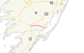
Maryland Route 366 highlighted in redRoute information Maintained by MDSHA Length: 11.17 mi[1] (17.98 km) Major junctions West end:  US 13 Bus. in Pocomoke City
 MD 12 in Stockton
East end: Entrance of George Island Landing Location Counties: Worcester Highway system Maryland highway system
Interstate • US • State • Minor • Former • Turnpikes←  MD 365
MD 367  →
→Maryland Route 366 (MD 366) is a state highway in the U.S. state of Maryland. Known for much of its length as Stockton Road, the state highway runs 11.17 miles (17.98 km) from U.S. Route 13 Business in Pocomoke City east to the entrance of George Island Landing on Chincoteague Bay. MD 366 is the main east–west highway of southern Worcester County, connecting US 13 in Pocomoke City with MD 12 in Stockton. The state highway was constructed starting in the mid 1910s from the Pocomoke City end. MD 366 was completed between Pocomoke City and Stockton in the early 1920s. The state highway was extended east to George Island Landing in the mid 1930s.
Contents
Route description
MD 366 begins at an intersection with US 13 Business (Market Street) on the southern edge of Pocomoke City. The state highway, marked as Stockton Road, turns south and then east to the intersection with US 13 (Ocean Highway). After crossing the federal highway, MD 366 heads east as a two-lane road, crosses Town Branch and passes Newtown Park. The state highway leaves the town of Pocomoke City after the intersection with Groton Road and Buck Harbor Road. After passing Byrd Road and crossing Pilchard Creek, MD 366 enters the hamlet of Goodwill, where the highway intersects Lambertson Road and Holly Swamp Road. After leaving Goodwill, the state highway meets unsigned MD 703 (Klej Grange Road). MD 366 continues east through farmland, intersecting Old Mill Road before entering the unincorporated village of Stockton. Within the village, the state highway intersects MD 12 (Snow Hill Road), where the name of MD 366 changes to George Island Landing Road. After passing Greenbackville Road, the state highway goes through a straight then performs an S-curve over the marshland of E.A. Vaughn Wildlife Management Area before meeting its eastern terminus at the entrance to the parking lot of George Island Landing on Chincoteague Bay.[1][2]
History
The Pocomoke City–Stockton road was paved within Stockton and from Market Street east to Groton Road in Pocomoke City by 1910.[3] Two sections of the state highway were paved from the Pocomoke City end in 1915 and 1917.[4][5] By 1921, 2-mile (3.2 km) sections were built from Stockton west to Old Mill Road and east to Goodwill from the Pocomoke City End.[6] The highway between Pocomoke City and Stockton was completed in 1923.[7] MD 366 was under construction from the eastern end of pavement in Stockton to George Island Landing by 1934 and completed in 1935.[8][9]
Junction list
The entire route is in Worcester County.
Location Mile
[1]Destinations Notes Pocomoke City 0.00 US 13 Bus. (Market Street) – Pocomoke CityWestern terminus 0.20  US 13 (Ocean Highway) – Salisbury, Norfolk
Goodwill 4.09  MD 703 west (Klej Grange Road) – Klej Grange
Stockton 8.39 MD 12 (Snow Hill Road) – Snow Hill, Sinnickson, VA9.46 Greenbackville Road south – Greenbackville, VA Former MD 502 George Island Landing 11.17 Entrance of George Island Landing Eastern terminus 1.000 mi = 1.609 km; 1.000 km = 0.621 mi References
- ^ a b c "Highway Location Reference: Worcester County" (PDF). Maryland State Highway Administration. 2009. http://www.marylandroads.com/Location/2009_WORCESTER.pdf. Retrieved 2010-10-24.
- ^ Google, Inc. Google Maps – Maryland Route 366 (Map). Cartography by Google, Inc. http://maps.google.com/maps?f=d&source=s_d&saddr=Pocomoke+Stockton+Rd&daddr=George+Island+Landing+Rd%2FMD-366+E&hl=en&geocode=FU7FRAIdrDh_-w%3BFUN4RAIdIhCC-w&mra=ls&sll=38.04074,-75.361447&sspn=0.007757,0.01929&ie=UTF8&t=h&z=12. Retrieved 2010-03-25.
- ^ Maryland Geological Survey. Map of Maryland (Map) (1910 ed.).
- ^ Report of the State Roads Commission of Maryland. 1912-1915. Baltimore: Maryland State Roads Commission. May 1915. p. 114. http://www.archive.org/details/annualreportsofs1912mary. Retrieved 2010-10-24.
- ^ Report of the State Roads Commission of Maryland. 1916-1919. Baltimore: Maryland State Roads Commission. January 1920. p. 55. http://www.archive.org/details/annualreportsofs1916mary. Retrieved 2010-10-24.
- ^ Maryland Geological Survey. Map of Maryland: Showing State Road System and State Aid Roads (Map) (1921 ed.).
- ^ Maryland Geological Survey. Map of Maryland: Showing State Road System and State Aid Roads (Map) (1923 ed.).
- ^ Report of the State Roads Commission of Maryland. 1931-1934. Baltimore: Maryland State Roads Commission. 1934-12-28. p. 363. http://www.archive.org/details/reportofstateroa1931mary. Retrieved 2010-10-24.
- ^ Maryland Geological Survey. Map of Maryland Showing State Road System: State Aid Roads and Improved County Road Connections (Map) (1935 ed.).
External links
Roads in Worcester County, Maryland State highways 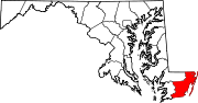
U.S. Highways Categories:- State highways in Maryland
- Roads in Worcester County, Maryland


Wikimedia Foundation. 2010.