- Maryland Route 374
-
Maryland Route 374
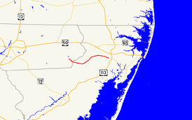
Maryland Route 374 highlighted in redRoute information Maintained by MDSHA Length: 9.98 mi[1][2] (16.06 km) Major junctions West end:  MD 354 in Powellville
East end:  MD 818 in Berlin
Location Counties: Wicomico, Worcester Highway system Maryland highway system
Interstate • US • State • Minor • Former • Turnpikes←  MD 373
MD 375  →
→Maryland Route 374 (MD 374) is a state highway in the U.S. state of Maryland. Known for much of its length as Libertytown Road, the state highway runs 9.98 miles (16.06 km) from MD 354 in Powellville east to MD 818 in Berlin. MD 374 was constructed between Berlin and Libertytown around 1930. The portion between Powellville and Libertytown was completed in the mid 1950s.
Contents
Route description
MD 374 begins at an acute intersection with MD 354 (Powellville Road) in Powellville. The state highway heads southeast as two-lane Burbage Crossing Road.[1][3] MD 374 crosses the Pocomoke River and enters Worcester County, where the highway's name changes to Libertytown Road.[2] The state highway curves northeast and passes through Libertytown, where the highway intersects Purnell Crossing Road and Ironshire Station Road, then crosses Libertytown Branch. After passing Bay Club Golf Course, MD 374 enters Berlin, where the name of the highway changes to Broad Street. The state highway crosses the Snow Hill Line of the Maryland and Delaware Railroad and enters downtown Berlin. MD 374 passes the western end of unsigned MD 375 (Commerce Street), which runs one-way westbound, before reaching its eastern terminus at an acute intersection with MD 818 (Main Street).[2][3]
History
The first part of MD 374 to be paved was Broad Street in Berlin in 1925.[4][5] The pavement was extended west to around Narrow Branch Road in 1929 and 1930 and to Libertytown by 1933.[6][7][8] A short segment was constructed west of Libertytown in 1937.[9] The section between Powellville and the western end of the existing section of MD 374 near Libertytown was constructed on mostly new alignment between 1952 and 1956.[10][11]
Junction list
County Location Mile
[1][2]Destinations Notes Wicomico Powellville 0.00 MD 354 (Powellville Road) – Willards, Snow HillWestern terminus Worcester Berlin 9.89 MD 375 (Commerce Street)MD 375 is unsigned and one-way westbound; use MD 818 north to access MD 375 9.98 MD 818 (Main Street) – Snow Hill, Selbyville, DEEastern terminus 1.000 mi = 1.609 km; 1.000 km = 0.621 mi References
- ^ a b c "Highway Location Reference: Wicomico County" (PDF). Maryland State Highway Administration. 2009. http://www.marylandroads.com/Location/2009_WICOMICO.pdf. Retrieved 2010-10-21.
- ^ a b c d "Highway Location Reference: Worcester County" (PDF). Maryland State Highway Administration. 2009. http://www.marylandroads.com/Location/2009_WORCESTER.pdf. Retrieved 2010-10-21.
- ^ a b Google, Inc. Google Maps – Maryland Route 374 (Map). Cartography by Google, Inc. http://maps.google.com/maps?f=d&source=s_d&saddr=Unknown+road&daddr=Broad+St&geocode=FTTHSAId1uOB-w%3BFb7JSAIdBECE-w&hl=en&mra=ls&sll=38.32458,-75.21918&sspn=0.000966,0.002411&ie=UTF8&t=h&z=13. Retrieved 2010-04-03.
- ^ Report of the State Roads Commission of Maryland. 1924-1926. Baltimore: Maryland State Roads Commission. January 1927. p. 100. http://www.archive.org/details/annualreportsofs1924mary. Retrieved 2010-04-03.
- ^ Maryland Geological Survey. Map of Maryland: Showing State Road System and State Aid Roads (Map) (1927 ed.).
- ^ Maryland Geological Survey. Map of Maryland Showing State Road System: State Aid Roads and Improved County Road Connections (Map) (1930 ed.).
- ^ Report of the State Roads Commission of Maryland. 1927-1930. Baltimore: Maryland State Roads Commission. 1930-10-01. p. 235. http://www.archive.org/details/annualreportsofs1927mary. Retrieved 2010-04-03.
- ^ Maryland Geological Survey. Map of Maryland Showing State Road System: State Aid Roads and Improved County Road Connections (Map) (1933 ed.).
- ^ Report of the State Roads Commission of Maryland. 1937-1938. Baltimore: Maryland State Roads Commission. 1939-03-04. p. 478. http://www.archive.org/details/annualreportsofs1937mary. Retrieved 2010-04-03.
- ^ Report of the State Roads Commission of Maryland. 1951-1952. Baltimore: Maryland State Roads Commission. 1952-12-15. pp. 114–115. http://www.archive.org/details/annualreportsofs1951mary. Retrieved 2010-04-03.
- ^ Maryland State Roads Commission. Maryland: Official Highway Map (Map) (1956 ed.).
External links
Roads in Wicomico County, Maryland State highways 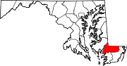
U.S. Highways Roads in Worcester County, Maryland State highways 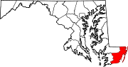
U.S. Highways Categories:- State highways in Maryland
- Roads in Wicomico County, Maryland
- Roads in Worcester County, Maryland


Wikimedia Foundation. 2010.