- Maryland Route 354
-
Maryland Route 354
Maryland Route 354 highlighted in redRoute information Maintained by MDSHA Length: 14.98 mi[1][2] (24.11 km) Major junctions South end:  MD 12 in Indiantown
 MD 374 in Powellville
 MD 350 in Powellville
 US 50 in Willards
North end:  MD 346 in Willards
Location Counties: Worcester, Wicomico Highway system Maryland highway system
Interstate • US • State • Minor • Former • Turnpikes←  MD 353
MD 355  →
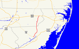
→Maryland Route 354 (MD 354) is a state highway in the U.S. state of Maryland. The state highway runs 14.98 miles (24.11 km) from MD 12 in Indiantown north to MD 346 in Willards. MD 354 parallels the Pocomoke River, connecting eastern Wicomico County and northwestern Worcester with Snow Hill. The state highway was first constructed from Willards in the mid 1910s. The remainder of MD 354 was completed in the late 1920s and early 1930s, with little change in the highway since.
Contents
Route description
MD 354 begins at an intersection with MD 12 in Indiantown. Nassawango Road heads southwest from the junction toward Pocomoke State Forest. MD 354 heads north as Whiton Road, a two-lane road that passes through farmland and parallels the Pocomoke River at a distance.[1][3] The state highway crosses Tilghman Race before passing through the hamlet of Whiton and entering Wicomico County, where the name of the highway changes to Powellville Road.[1][2][3] In Powellville, MD 354 intersects MD 374 (Burbage Crossing Road) at an acute angle and MD 350 (Mount Hermon Road) at a right angle before crossing Adkins Mill Pond. After passing through more farmland, the state highway enters the town of Willards and intersects U.S. Route 50 (Ocean Gateway).[2] MD 354 continues north to its terminus at MD 346 (Old Ocean City Road), where Main Street continues north into the center of Willards.[2][3]
History
The first section of the highway that was to become MD 354 was paved from the Pennsylvania Railroad crossing on the north side of Willards south to Friendship Road north of Powellville in 1917.[4] The pavement was extended south to Powellville by 1921.[5] Paving began from Indiantown toward Whiton by 1927.[6][7] MD 354 was completed south to Whiton in 1930.[8] The gap south of Whiton was filled in 1933, completing the highway.[9][10] The state highway between Powellville and Willards was widened in 1956, the same year the northern end was rolled back from the railroad crossing in Willards to US 50 (now MD 346).[11][12]
Junction list
County Location Mile
[2][1]Destinations Notes Worcester Indiantown 0.00 Nassawango Road south – Pocomoke State Forest Southern terminus MD 12 (Snow Hill Road) – Snow Hill, SalisburyWicomico Powellville 10.13 MD 374 east (Burbage Crossing Road) – Berlin10.49 MD 350 west (Mount Hermon Road) – SalisburyWillards 14.79 US 50 (Ocean Gateway) – Ocean City, Salisbury14.98 MD 346 (Old Ocean City Road) – Pittsville, WhaleyvilleNorthern terminus Main Street north 1.000 mi = 1.609 km; 1.000 km = 0.621 mi References
- ^ a b c d "Highway Location Reference: Worcester County" (PDF). Maryland State Highway Administration. 2009. http://www.marylandroads.com/Location/2009_WORCESTER.pdf. Retrieved 2010-10-22.
- ^ a b c d e "Highway Location Reference: Wicomico County" (PDF). Maryland State Highway Administration. 2009. http://www.marylandroads.com/Location/2009_WICOMICO.pdf. Retrieved 2010-10-22.
- ^ a b c Google, Inc. Google Maps – Maryland Route 354 (Map). Cartography by Google, Inc. http://maps.google.com/maps?f=d&source=s_d&saddr=MD-354+N%2FWhiton+Rd&daddr=Main+St&hl=en&geocode=FT66RgIdPl6B-w%3BFWjESQIdZDeC-w&mra=ls&sll=38.205409,-75.358315&sspn=0.061915,0.154324&ie=UTF8&t=h&z=11. Retrieved 2010-04-01.
- ^ Report of the State Roads Commission of Maryland. 1916-1919. Baltimore: Maryland State Roads Commission. January 1920. p. 53. http://www.archive.org/details/annualreportsofs1916mary. Retrieved 2010-04-01.
- ^ Maryland Geological Survey. Map of Maryland: Showing State Road System and State Aid Roads (Map) (1921 ed.).
- ^ Report of the State Roads Commission of Maryland. 1924-1926. Baltimore: Maryland State Roads Commission. January 1927. p. 100. http://www.archive.org/details/annualreportsofs1924mary. Retrieved 2010-04-01.
- ^ Maryland Geological Survey. Map of Maryland: Showing State Road System and State Aid Roads (Map) (1927 ed.).
- ^ Report of the State Roads Commission of Maryland. 1927-1930. Baltimore: Maryland State Roads Commission. 1930-10-01. pp. 234–235. http://www.archive.org/details/reportofstateroa1927mary. Retrieved 2010-04-01.
- ^ Maryland Geological Survey. Map of Maryland Showing State Road System: State Aid Roads and Improved County Road Connections (Map) (1933 ed.).
- ^ Report of the State Roads Commission of Maryland. 1931-1934. Baltimore: Maryland State Roads Commission. 1934-12-28. p. 362. http://www.archive.org/details/reportofstateroa1931mary. Retrieved 2010-04-01.
- ^ Report of the State Roads Commission of Maryland. 1955-1956. Baltimore: Maryland State Roads Commission. 1956-11-02. p. 125. http://www.archive.org/details/reportofstateroa1955mary. Retrieved 2010-04-01.
- ^ Maryland State Roads Commission. Maryland: Official Highway Map (Map) (1956 ed.).
External links
Roads in Wicomico County, Maryland State highways 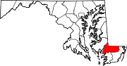
U.S. Highways Roads in Worcester County, Maryland State highways 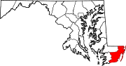
U.S. Highways Categories:- State highways in Maryland
- Roads in Wicomico County, Maryland
- Roads in Worcester County, Maryland


Wikimedia Foundation. 2010.