- Maungaturoto
-
Maungaturoto 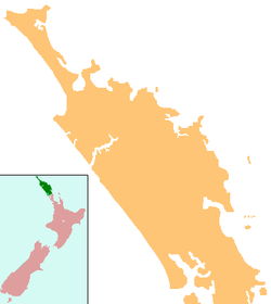
 Maungaturoto
Coordinates: 36°06′35″S 174°21′15″E / 36.10972°S 174.35417°E Country New Zealand Region Northland Region District Kaipara District Population (2006) - Total 837 Maungaturoto is a small town in the Northland Region of New Zealand. The population was 837 in the 2006 Census, an increase of 87 from 2001.[1] It is the second largest settlement in the Kaipara District.
The township is located close to the Otamatea River, an estuarial arm of the Kaipara Harbour 25 kilometres north of Wellsford and 45 kilometres south of Whangarei. Maungaturoto also has its own motocross club (http://maungaturotomc.co.nz) where members regularly meet.
Five kilometres southeast of Maungaturoto is the antipodean point of Gibraltar.
Education
Otamatea High School is a secondary (years 7-13) school with a roll of 528.[2] The school celebrated its 40th reunion in 2006.[3] The District High School was established in Maungaturoto in 1939.[4] Otamatea High School won the Goodman Feilder Composite School of the Year Award in 2000.[5]
Maungaturoto School is a contributing primary (years 1-6) school with a roll of 206.[6] A school first opened in Maungaturoto in 1874.[7]
Otamatea Christian School is a private composite (years 1-13) school with a roll of 39.[8] It is a ministry of the Maungaturoto Congregational Church. [9]
All these schools are coeducational and have a decile rating of 6.
Notes
- ^ Quickstats about Maungaturoto
- ^ "Te Kete Ipurangi - Otamatea High School". Ministry of Education. http://www.tki.org.nz/e/schools/display_school_info.php?school_id=21.
- ^ "Otamatea High School and Maungaturoto District High School 40th Reunion 2006" ([dead link] – Scholar search). Education Gazette New Zealand 85 (1). 6 February 2006. http://www.edgazette.govt.nz/notices.php?action=view&id=61415.
- ^ Ryburn, Wayne (1999). Tall Spars, Steamers & Gum. Auckland, N.Z.: Kaipara Publications. p. 167. ISBN 0-473-06176-7.
- ^ "Welcome to Maungaturoto Information Pack". Real Town Maungaturoto Inc. p. 3. http://www.realtownmaungaturoto.co.nz/PDF%20Files/Maunagturoto%20Welcome%20Pack.pdf. Retrieved 19 November 2010.
- ^ "Te Kete Ipurangi - Maungaturoto School". Ministry of Education. http://www.tki.org.nz/e/schools/display_school_info.php?school_id=1049.
- ^ Ryburn, p 222
- ^ "Te Kete Ipurangi - Otamatea Christian School". Ministry of Education. http://www.tki.org.nz/e/schools/display_school_info.php?school_id=283.
- ^ "Ministry Otamatea Christian College". Maungaturoto Congregational Church. http://church.kenweb.co.nz/index.php?title=Ministry_Otamatea_Christian_School&oldid=781.
External links
Categories:- Populated places in New Zealand
- Kaipara District

Wikimedia Foundation. 2010.