- Mount Coe
-
Mount Coe 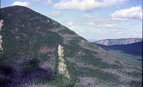
Elevation 3,795 ft (1,157 m) [1] Prominence 315 ft (96 m) [1] Listing Location Location in Maine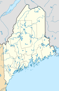
 Mount Coe
Location Piscataquis County, Maine Coordinates 45°56′01″N 69°00′32″W / 45.93371°N 69.00901°WCoordinates: 45°56′01″N 69°00′32″W / 45.93371°N 69.00901°W[2] Topo map USGS Doubletop Mountain Climbing Easiest route hiking trail Mount Coe is a mountain located in Piscataquis County, Maine, within Baxter State Park, about 5.5 mi (9 km) northwest of Mount Katahdin. Mt. Coe is flanked to the northeast by South Brother, and to the southwest by Mount O-J-I. The Mount Coe trail starts at Slide Dam on Newsowdnehunk Stream east bank at around 1190 ft. The trail goes up to the east for about 1.2 miles and then goes right (south) along the drainage from the Mt. Coe slide bending to the east and then northeast. The last 1/2 mile is up the slide featured on the left margin of the photo where the trail gains around 800 feet.
Mount Coe, ranked 22nd in height among Maine peaks, stands within the watershed of the Penobscot River, which drains into Penobscot Bay. The east side of Mt. Coe drains into a swampy area called "The Klondike", thence into Wassataquoik Stream, and the East Branch of the Penobscot River. The northwest and southwest sides of Mt. Coe drain into Nesowdnehunk Stream, thence into the West Branch of the Penobscot River.
See also
References
- ^ a b "Mount Coe". Peakbagger.com. http://www.peakbagger.com/peak.aspx?pid=6812. Retrieved 2007-05-09.
- ^ "Mount Coe". Geographic Names Information System, U.S. Geological Survey. http://geonames.usgs.gov/pls/gnispublic/f?p=gnispq:3:::NO::P3_FID:564149. Retrieved 2007-05-09.
Categories:- Mountains of Maine
- New England Hundred Highest
- Mountains of Piscataquis County, Maine
- Maine geography stubs


Wikimedia Foundation. 2010.