- Dohna
-
"Dohna" redirects here. For other uses, see Dohna (disambiguation).
Dohna Dohna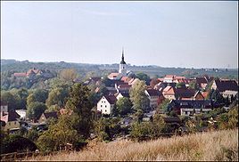


 DohnaLocation of the town of Dohna within Sächsische Schweiz-Osterzgebirge district
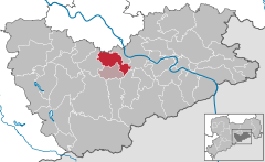

Coordinates 50°57′17″N 13°51′27″E / 50.95472°N 13.8575°ECoordinates: 50°57′17″N 13°51′27″E / 50.95472°N 13.8575°E Administration Country Germany State Saxony Admin. region Dresden District Sächsische Schweiz-Osterzgebirge Municipal assoc. Dohna-Müglitztal Town subdivisions 12 Mayor Friedhelm Putzke Basic statistics Area 28.57 km2 (11.03 sq mi) Elevation 130-150 m Population 6,145 (31 December 2010)[1] - Density 215 /km2 (557 /sq mi) Other information Time zone CET/CEST (UTC+1/+2) Licence plate PIR Postal code 01809 Area code 03529 Website www.stadt-dohna.de Dohna is a town in the Sächsische Schweiz-Osterzgebirge district, Saxony, Germany. It is located south of Heidenau. It is located in the Müglitz valley and lies west of the Eastern Ore Mountains. It was known as Donin in 1107, 1160 and until 1206. Donyn in from 1288 to 1408. Doneyn unwil 1454 and other forms were Dhonin, Donow and became Dohna. The name comes from Property of the Doň(s) from the Bohemian first name Zdoň.
It is accessed by routes 172 and 172A, and by the A17 at the Pirna interchange.
Contents
History
Dohna is one of the oldest towns in Saxony. It dates back to the 16th century BC and the Bronze Age. It was first mentioned in 960 in a document by emperor Otto I.
It was linked by the Bohemian Road and the Old Dresden to Teplitz Post Road. The burgraviate was situated between the Margraviate of Meissen, the Kingdom of Bohemia and Gottleuba.
The Donins were defeated in 1402 in the Dohna Feud. The castle was the seat until 1460 as it moved to Sonnenstein Castle in Pirna.
Its constitution was established in 1845. The city was devastated by French and Russian troops during the Napoleonic Wars.
In 1999, Köttewitz and Krebs joined Dohna. In January 1, 2002, Dohna became the seat of Verwaltungsgemeinschaft Dohna.
Municipality subdivisions
- Borthen
- Bosewitz
- Burgstädtel
- Dohna
- Gamig
- Gorknitz
- Köttewitz
- Krebs
- Meusegast
- Röhrsdorf
- Sürßen
- Tronitz
Main sights
- Castle tower, constructed in the 19th century
- Postmeilensäule, built in 1731
- Alten Apotheke, built in 1690, a local historical museum since 1992.
Schools:
- Primary school
- Middle School, built on September 7, 1891
- Gymnasium, built in 1892
- In 1969, the schools were named Marie Curie
References
- ^ "Bevölkerung des Freistaates Sachsen jeweils am Monatsende ausgewählter Berichtsmonate nach Gemeinden" (in German). Statistisches Landesamt des Freistaates Sachsen. 31 December 2010. http://www.statistik.sachsen.de/download/010_GB-Bev/Bev_Gemeinde.pdf.
Altenberg | Bad Gottleuba-Berggießhübel | Bad Schandau | Bahretal | Bannewitz | Dippoldiswalde | Dohma | Dohna | Dorfhain | Dürrröhrsdorf-Dittersbach | Freital | Glashütte | Gohrisch | Hartmannsdorf-Reichenau | Heidenau | Hermsdorf | Höckendorf | Hohnstein | Kirnitzschtal | Königstein | Kreischa | Liebstadt | Lohmen | Müglitztal | Neustadt in Sachsen | Pirna | Porschdorf | Pretzschendorf | Rabenau | Rathen | Rathmannsdorf | Reinhardtsdorf-Schöna | Rosenthal-Bielatal | Schmiedeberg | Sebnitz | Stadt Wehlen | Stolpen | Struppen | Tharandt | Wilsdruff Categories:
- Towns in Saxony


Wikimedia Foundation. 2010.