- Bandiagara Escarpment
-
 Remnant dwellings of the ancient Tellem people in the background and a mud mosque of the modern-day Dogon people in the foreground
Bandiagara Escarpment (Cliffs of Bandiagara) IUCN Category III (Natural Monument)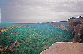
The Bandiagara Escarpment from BanimotoLocation Mopti Region, Mali Coordinates 14°21′32″N 3°35′42″W / 14.35889°N 3.595°WCoordinates: 14°21′32″N 3°35′42″W / 14.35889°N 3.595°W Area 4,000 km² Established 1985 Official name: Cliff of Bandiagara (Land of the Dogons) Type: Mixed Criteria: v, vii Designated: 1989 (13th session) Reference #: 516 State Party:  Mali
MaliRegion: Africa The Bandiagara Escarpment is an escarpment in the Dogon country of Mali. The sandstone cliff rises about 500 meters above the lower sandy flats to the south. It has a length of approximately 150 kilometers. The area of the escarpment is inhabited today by the Dogon people. Before the Dogon, the escarpment was inhabited by the Tellem and Toloy. Many structures remain from the Tellem. The Bandiagara Escarpment was listed in the UNESCO World Heritage List in 1989.
The Cliffs of Bandiagara are a sandstone chain ranging from south to northeast over 200 km and extending to the Grandamia massif. The end of the massif is marked by the Hombori Tondo, Mali's highest peak at 1,115 meters. Because of its archaeological, ethnological and geological characteristics, the entire site is one of the most imposing in West Africa.
Contents
History
The cave-dwelling Tellem, an ethnic group later pushed out by the arrival of the Dogons, used to live in the slopes of the cliff. The Tellem legacy is evident in the caves they carved into the cliffs so that they could bury their dead high up, far from the frequent flash floods of the area. Dozens of villages are located along the cliff, such as Kani Bonzon. It was near to this village that the Dogons arrived in the 14th century, and from there they spread over the plateau, the escarpment and the plains of the Seno-Gondo.
An unconfirmed theory explaining why the Dogon were relatively undisturbed by the French colonial powers posits the existence of a series of natural tunnels weaving through the Bandiagara Escarpment, which only the Dogon know about, and thus were able to use these caves to surprise and drive away any aggressors.
The Bandiagara Escarpment Today
 A partial view of the Bandiagara Escarpment
Today, local guides can take tourist groups on trips along the escarpment to visit the Dogon villages. A series of trails runs along the cliffs, and hostels in each village provide food and lodging. The host villages receive income from the hostels and the tourist tax. Large increases in tourism to the area are expected, as a new highway is constructed, putting pressure on local, traditional cultures.[1] In addition, The Independent reports that looting of ancient artifacts is widespread in the area, which is poorly policed.[2] To call attention to the issue of uncontrolled tourist visitation, the World Monuments Fund included the Bandiagara Escarpment in the 2004 World Monuments Watch. In 2005, WMF provided a grant from American Express to the Mission Culturelle de Bandiagara for the development of a management plan.[3] Beyond the protection of traditional buildings, the management plan calls for the regulation of new construction through the establishment of strict building guidelines such as those that govern new development in historic districts around the world.
References
- ^ Baxter, Joan (16 April, 2001). "Mali: What Price Tourism?". BBC News. http://news.bbc.co.uk/2/hi/africa/1280076.stm.
- ^ Smith, Alex Duval (17 March 2001). "Mali Plunders its Desert Heritage to Feed Demand for 'Primitive' Art". The Independent. http://www.independent.co.uk/news/world/africa/mali-plunders-its-desert-heritage-to-feed-demand-forprimitive-art-687697.html.
- ^ World Monuments Fund - Bandiagara Escarpment Cultural Landscape
External links
- UNESCO - Cliff of Bandiagara (Land of the Dogons)
- Thierry Joffroy and Lassana Cissé, "Culture at a Crossroads: For Mali’s Bandiagara Escarpment, extraordinary geology and human genius have conspired to create one of the world’s great cultural landscapes. For the Dogon cliff-dwellers who live there, the future hangs in the balance." ICON Magazine, Fall 2005, p. 38-45.
United States Ancient Pueblo dwellings in Arizona - Ancient Pueblo dwellings in Colorado - Ancient Pueblo dwellings in New Mexico - Ancient Pueblo dwellings in Utah - Ancient Pueblo dwellings in Texas - Ancient Pueblo dwellings in NevadaMexico Ancient Pueblo dwellings in Chihuahua - Ancient Pueblo dwellings in Sonora - Huápoca - Cuarenta CasasAfrica Bandiagara EscarpmentAsia Categories:- IUCN Category III
- Archaeological sites in Mali
- World Heritage Sites in Mali
- Escarpments
- Landforms of Mali
- Cliffs
- Former populated places in Mali
- Cliff dwellings


Wikimedia Foundation. 2010.