- 2003–04 Australian region cyclone season
Infobox hurricane season
Basin=Aus
Year=2004
Track=2003-2004 Australian cyclone season summary.jpg
First storm formed=December 7 ,2003
Last storm dissipated=March 28 ,2004
Strongest storm name=Fay
Strongest storm pressure=910
Strongest storm winds=115
Average wind speed=10
Total depressions=
Total storms=10
Total hurricanes=5
Total intense=
Fatalities=
Da
Inflated=
five seasons=2001–02, 2002–03, 2003–04, 2004–05, 2005–06The 2003-04 Australian region cyclone season was an event in the ongoing cycle oftropical cyclone formation. It began onNovember 1 ,2003 and ended onApril 30 ,2004 . The regional tropical cyclone operational plan also defines a "tropical cyclone year" separately from a "tropical cyclone season", which runs fromJuly 1 ,2003 toJune 30 ,2004 .Tropical cyclones in this area are monitored by four
Tropical Cyclone Warning Centre s (TCWCs): the Australian Bureau of Meteorology in Perth, Darwin, andBrisbane ; and TCWCPort Moresby inPapua New Guinea .http://www.wmo.ch/web/www/TCP/TCP24-English2004.pdf]__TOC__
torms
evere Tropical Cyclone Jana
Infobox Hurricane Small
Basin=Aus
Formed=December 7
Dissipated=December 12 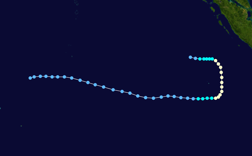
10-min winds=75
1-min winds=80
Pressure=960Formed onDecember 7 and dissipated onDecember 12 . [http://www.australiansevereweather.com/cyclones/2004/summ0312.htm Monthly Global Tropical Cyclone Summary December 2003 ] ]evere Tropical Cyclone Debbie
Infobox Hurricane Small
Basin=Aus
Formed=December 17
Dissipated=December 21 
10-min winds=65
1-min winds=70
Pressure=970Formed onDecember 17 and dissipated onDecember 21 . Crossed theNorthern Territory coast as a Category 3.Tropical Low Ken
Infobox Hurricane Small
Basin=Aus
Type=low
Formed=January 1
Track=Ken 2004 track.pngJanuary 6
10-min winds=35
1-min winds=35
Pressure=997January 1 ,2004 and dissipated onJanuary 6 . [http://www.australiansevereweather.com/cyclones/2004/summ0401.htm Monthly Global Tropical Cyclone Summary January 2004 ] ] Operationally monitored Ken to have reached tropical cyclone intensity for 24 hours, but post-analysis revealed that Ken never was a tropical cyclone. [ [http://australiasevereweather.com/cyclones/tropical_cyclones_2004_australian_region.htm July 2003 to June 2004 Tropical Cyclones in the Australian Region ] ]Monsoon Depression
Existed between
January 10 toJanuary 17 . Caused heavy rainfall across westernQueensland andNew South Wales .Tropical Cyclone Linda
Infobox Hurricane Small
Basin=Aus
Formed=January 28 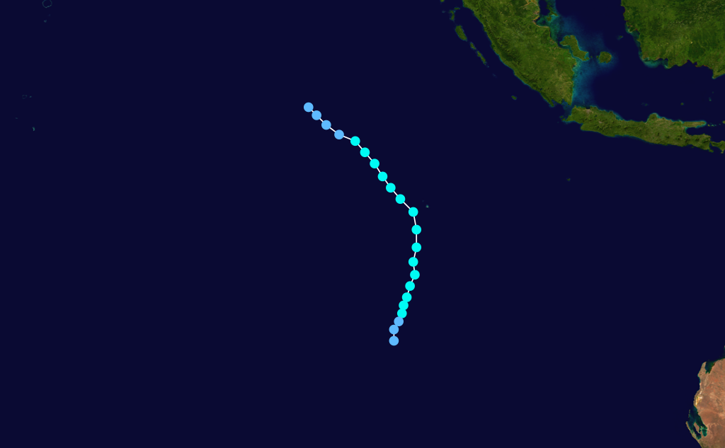
Dissipated=February 1
10-min winds=55
1-min winds=60
Pressure=978Formed onJanuary 28 and dissipated onFebruary 1 .Tropical Cyclone Fritz
Infobox Hurricane Small
Basin=Aus
Formed=February 8
Dissipated=February 12

10-min winds=50
1-min winds=35
Pressure=985A tropical low developed onFebruary 8 in the northernCoral Sea , within an active monsoon trough. The system developed rapidly and becoming Tropical Cyclone Fritz onFebruary 10 , when it was northeast ofCooktown . Fritz moved rapidly to the west, and made landfall on the northernQueensland coast with winds of 75 km/h. The storm lost its tropical character as it crossed theCape York Peninsula and entered theGulf of Carpentaria onFebruary 11 . The low reintensified over the favourable conditions in the Gulf, and reached its peak with 95 km/h winds nearMornington Island . Radar imagery showed evidence of an eye as the storm passed over the island onFebruary 12 . It then crossed over the coast onto mainland Australian and degenerated overland. The remnant travelled overNorthern Territory andWestern Australia , before merging with a cold front to the south of Perth.Cyclone Fritz brought up to 309 mm of rain to the
Cairns area. This led to a number of landslides, one of which caused severe property damage inYorkeys Knob . There was flash flooding near Innisfail when 74 mm of rain fell in one hour. Fritz uprooted a number of trees on Mornington Island, but there was no other damage there. There were no casualties from the storm. [http://www.australiansevereweather.com/cyclones/2004/summ0402.htm Monthly Global Tropical Cyclone Summary February 2004 ] ]evere Tropical Cyclone Monty
Infobox Hurricane Small
Basin=Aus
Formed=February 26 
Dissipated=March 2
Track=Monty 2004 track.png
1-min winds=100
Pressure=935February 27, 2004 . Monty then strengthened into aCategory 4 cyclone as it moved parallel with thePilbara coast . The cyclone made landfall near Mardie cattle station as aCategory 3 cyclone onMarch 1 . Monty damaged several boats and caused isolated flooding.Tropical Cyclone Evan
Infobox Hurricane Small
Basin=Aus
Formed=February 29 
Dissipated=March 6
Track=Evan 2004 track.png
1-min winds=30
Pressure=994February 29 and dissipated onMarch 6 . CrossedGroote Eylandt and theNorthern Territory mainland, causing flooding. [http://www.australiansevereweather.com/cyclones/2004/summ0403.htm Monthly Global Tropical Cyclone Summary March 2004 ] ]ubtropical Storm
Formed on
March 2 and crossed the coast in southeastQueensland onMarch 5 , bringing heavy rain and strong winds. A storm surge caused inundation along the coasts.Tropical Cyclone Nicky-Helma
Infobox Hurricane Small
Basin=Aus
Formed=March 8
Dissipated=March 13
Track=Nicky-Helma 2004 track.png
1-min winds=65
Pressure=972March 8 , moved west of the region onMarch 10 , and was renamed Helma.evere Tropical Cyclone Fay
Infobox Hurricane Small
Basin=Aus
Formed=March 14 
Dissipated=March 28
Track=Fay 2004 track.png
1-min winds=120
Pressure=910Gulf of Carpentaria and moved westward into theTimor Sea ; it was named Tropical Cyclone Fay onMarch 16 . Fay was 400 km north of Wyndham and 330 kilometres west northwest of Darwin. There were reports along the Kimberley Coast of gale force winds. OnMarch 21 , Cyclone Fay intensified even further as the storm approachedScott Reef where significant damage occurred. Looping back towards the Kimberley coast, Fay - now a Category 3 system - approached to within 90 km of Broome onMarch 25 , before turning to the south-west. Broome experienced strong winds with gale-force gusts, some heavy rain and heavy seas but escaped serious damage.Fay then headed further away from the coast on the 25th before resuming a general southerly track on the 26th. Fay crossed the Pilbara coast between the pastoral stations of
Pardoo andWallal between 8 am and 9 am WST onMarch 27 as a Category 4 storm with estimated maximum wind gusts of around 235 km/h near the center. [http://www.bom.gov.au/weather/wa/cyclone/about/seasonsummary200304.shtml BoM - WA Tropical Cyclone Season Summary 2003-04 ] ]The cyclone weakened as it moved inland. Little wind damage was reported from the storm despite its intensity as it made landfall in a remote part of the WA coast and consequently only impacted sparsely populated pastoral and mining areas. As the system passed close to the Yarrie mine it's translation speed reduced and some 200 workers were locked down for 8 hours in two squash courts as accommodation units were overturned, water tanks "shredded" and power lines cut. Fay appears to have weakened below cyclone strength on Sunday evening (
March 28 ) between Nullagine andTelfer .Cyclone Fay caused extensive flooding and considerable damage. Fortunately, there were no deaths.
Tropical Cyclone Grace
Infobox Hurricane Small
Basin=Aus
Formed=March 18 
Dissipated=March 24
Track=Grace 2004 track.png
1-min winds=55
Pressure=985Grace moved toward the southeast at 15 to convert|20|kn|km/h. This general motion was to continue for the remainder of the cyclone's life. Grace peaked in intensity at 985 hPa with maximum sustained winds of convert|50|kn|km/h near 20.3S/155.9E at 22/0000 UTC. This intensity was maintained for approximately 6 hours. Thereafter, Grace began to undergo extratropical transition with anincreasingly asymmetric wind field due to a squeeze with a surface ridge to the south. Grace rapidly lost its entire upper-level structure and was downgraded at 23/1800 UTC from tropical cyclone status when located approximately about convert|400|nmi|km east-northeast of Sandy Cape (23.6S/162.3E). The remnant surface wind field of the system meandered to the east and then to the east-northeast over the following days, producing a very broad area of gales to its south through the Tasman Sea. The highest three-day rainfall amounts for Grace was 759 mm from Topaz, which received 372 mm in 24 hours. The strongest winds from the mainland were from Low Isle at 18/1311 UTC when gusts reached convert|50|kn|km/h. Cape Moreton at 21 March 2004 2230 UTC received gusts to convert|54|kn|km/h. Widespread flooding and damage to roads and property along the far north Queensland coast, mainly between Cooktown and Cairns. Winds and waves brought tide levels above the highest tides of the year and this was particularly evident at Cooktown. Floodwaters closed all major roads into Cairns. A large section of one lane of the Captain Cook Highway north of Cairns collapsed after a landslide consisting of nearly 20 metres of rock and boulders the size of cars destroyed the ocean-side road. The scenic coastal highway and link between Cairns and Port Douglas was closed for several days. Residents were evacuated from the Whitfield range area due to landslides. An estimated $20,000,000 (US) damage to the Cairns region is attributed to pre-cyclone Grace. There were no casualties associated with Tropical Cyclone Grace. In New Caledonia, further strong winds, heavy rains and flooding were experienced. A massive oil slick threatened a popular tourist beach in New Caledonia. Officials in the French Pacific territory put up barriers around the island of Amedee, which was threatened by a toxic oil slick, estimated to cover an area of 20 square kilometres. They said the oil had come from a boat wrecked several decades ago on a coral reef off South Province.
evere Tropical Cyclone Oscar-Itseng
Infobox Hurricane Small
Basin=Aus
Formed=March 20
Dissipated=March 27 (Moved out of Region)
10-min winds=95
1-min winds=115
Pressure=935Formed onMarch 20 , moved out of the region onMarch 27 into South-West Indian Ocean region, renaming to Itseng.torm names
Tropical cyclones are assigned names by the Australian Bureau of Meteorology or
Papua New Guinea .Tropical cyclones are named if they are non-frontal low pressure systems of synoptic scale developing over warm waters, or Dvorak intensity analysis indicate the presence of gale force or stronger winds near the centre. Therefore, a tropical system with gales in one or more quadrants, but not near the centre, are not named.http://www.wmo.ch/web/www/TCP/OperationPlans/TCP24-English2004.pdf]
All names assigned in the Australian region are used sequentially, unlike lists used annually by the
National Hurricane Centre in theAtlantic Ocean and eastPacific Ocean . Only the names used during this cyclone season are listed below. The complete list of names for each basin are found in theWorld Meteorological Organization 's [http://www.wmo.ch/web/www/TCP/FactShtTCNames1July05.pdf official list] .outheast Indian Ocean
Tropical cyclones that develop east of 90°E, south of the
Equator , and west of 125°E are assigned names by the Tropical Cyclone Warning Centre in Perth,Western Australia .*Jana
*Ken
*Linda
*Monty
*Nicky
*OscarArafura Sea and Western Gulf of Carpentaria
Tropical cyclones that develop south of the Equator between 125°E and 141°E are assigned names by the Tropical Cyclone Warning Centre in Darwin,
Northern Territory .*Debbie
*Evan
*FayCoral Sea and Eastern Gulf of Carpentaria
Tropical cyclones that develop south of 10°S between 141°E and 160°E are assigned names by the Tropical Cyclone Warning Centre in
Brisbane ,Queensland .*Fritz
*Graceolomon Sea and Gulf of Papua
Tropical cyclones that develop north of 10°S between 141°E and 160°E are assigned names by the Tropical Cyclone Warning Centre in
Port Moresby ,Papua New Guinea .No tropical cyclone names were used in the 2003-04 season.
References
ee also
*
List of Southern Hemisphere cyclone seasons
*2003 Atlantic hurricane season
*2004 Atlantic hurricane season
*2003 Pacific hurricane season
*2004 Pacific hurricane season
*2003 Pacific typhoon season
*2004 Pacific typhoon season
*2003 North Indian Ocean cyclone season
*2004 North Indian Ocean cyclone season External links
* [https://metocph.nmci.navy.mil/jtwc.html Joint Typhoon Warning Center (JTWC)] .
* [http://www.bom.gov.au/weather/wa/cyclone/ Australian Bureau of Meteorology (TCWC Perth)] .
* [http://www.bom.gov.au/weather/nt/cyclone/ Australian Bureau of Meteorology (TCWC Darwin)] .
* [http://www.bom.gov.au/weather/qld/cyclone/ Australian Bureau of Meteorology (TCWC Brisbane)] .
* [http://www.wmo.int/index-en.html World Meteorological Organization]
Wikimedia Foundation. 2010.