- East Cottingwith
-
Coordinates: 53°52′21″N 0°55′52″W / 53.872591°N 0.931071°W
East Cottingwith 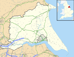
 East Cottingwith
East Cottingwith shown within the East Riding of YorkshirePopulation 290 (2001 census)[1] OS grid reference SE703423 Parish East Cottingwith Unitary authority East Riding of Yorkshire Ceremonial county East Riding of Yorkshire Region Yorkshire and the Humber Country England Sovereign state United Kingdom Post town YORK Postcode district YO42 Dialling code 01759 Police Humberside Fire Humberside Ambulance Yorkshire EU Parliament Yorkshire and the Humber UK Parliament East Yorkshire List of places: UK • England • Yorkshire East Cottingwith is a village and civil parish in the East Riding of Yorkshire, England. It is situated approximately 9 miles (14 km) north west of the market town of Howden and 7 miles (11 km) south west of the market town of Pocklington. It lies 1 mile (1.6 km) west of the B1228 road and just east of the River Derwent.
 Narrowboat at Cottingwith Lock, near East Cottingwith
The civil parish is formed by the village of East Cottingwith and the hamlet of Storwood. According to the 2001 UK census, East Cottingwith parish had a population of 290.[1]
References
- ^ a b "2001 Census: Key Statistics: Parish Headcounts: Area: Cottingwith CP (Parish)". Neighbourhood Statistics. Office for National Statistics. http://neighbourhood.statistics.gov.uk/dissemination/LeadTableView.do?a=3&b=790943&c=Cottingwith&d=16&e=15&g=391452&i=1001x1003x1004&m=0&r=1&s=1210885865218&enc=1&dsFamilyId=779. Retrieved 15 May 2008.
- Gazetteer — A–Z of Towns Villages and Hamlets. East Riding of Yorkshire Council. 2006. p. 5.
Categories:- Villages in the East Riding of Yorkshire
- Civil parishes in the East Riding of Yorkshire
- East Riding of Yorkshire geography stubs


Wikimedia Foundation. 2010.