- Oare, Kent
-
Coordinates: 51°19′48″N 0°52′41″E / 51.330°N 0.878°E
Oare 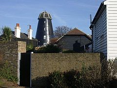
Oare windmill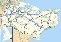
 Oare
Oare
Oare shown within KentParish Oare District Swale Shire county Kent Region South East Country England Sovereign state United Kingdom Police Kent Fire Kent Ambulance South East Coast EU Parliament South East England UK Parliament Faversham and Mid-Kent List of places: UK • England • Kent Oare is a village and civil parish north of Faversham in southeast England. It is separated from Faversham by the Oare Creek. To the north of the village are the Oare Marshes, and the Harty Ferry which linked to Harty on the Isle of Sheppey. Kent Wildlife Trust manages a nature reserve that is an important stopping place for migatory birds.
Towns and villages in the Borough of Swale in Kent, England 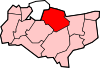 Bapchild · Badlesmere · Bay View · Bobbing · Borden · Boughton Street · Boughton under Blean · Bredgar · Brogdale · Buckland · Chestnut Street · Conyer · Dargate · Davington · Denstroude · Doddington · Dunkirk · Eastchurch · Eastling · Elmley · Faversham · Faversham Without · Goodnestone · Graveney · Halfway Houses · Hartlip · Harty · Heart's Delight, Swale · Hernhill · Highsted · Iwade · Kemsley · Keycol · Kingsdown · Leaveland · Leysdown-on-Sea · Lower Halstow · Luddenham · Lynsted · Milstead · Milton Regis · Minster · Mockbeggar · Murston · Newington · Newnham · Norton · Oad Street · Oare · Ospringe · Oversland · Painters Forstal · Queenborough · Rodmersham Green · Rushenden · Selling · Sheldwich · Shellness · Sheerness · Sittingbourne · Stalisfield Green · Teynham · Throwley · Tonge · Tunstall · Upchurch · Uplees · Warden · Waterham · Whitehill
List of places in Kent Categories:- Swale
- Villages in Kent
- Civil parishes in Kent
- Kent geography stubs


Wikimedia Foundation. 2010.