- Onehunga
-
For other uses, see Onehunga (disambiguation).
Onehunga 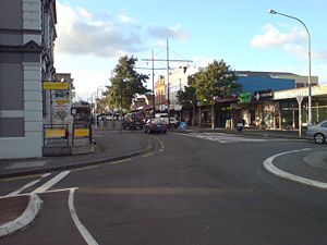
Onehunga Mall from near the southern end.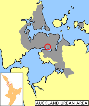
Location of Onehunga in Auckland.Basic information Local authority Auckland City Date established 1843 (European) Population 18,000 (????) Facilities Train station(s) Onehunga Train Station (reopened 2010) Surrounds North One Tree Hill Northeast Oranga East Te Papapa Southeast (Manukau Harbour) South (Manukau Harbour), Mangere Bridge Southwest (Manukau Harbour) West Hillsborough Northwest Royal Oak Onehunga is a suburb of Auckland City, New Zealand and the location of the Port of Onehunga, the city's small port on the Manukau Harbour. It is eight kilometres south of the city centre, close to the volcanic cone of One Tree Hill, Maungakiekie.
The residential and light-industrial suburb, with its approximately 18,000 residents and almost 1,000 commercial and industrial businesses,[1] stretches south from Royal Oak to the north shore of the Manukau Harbour. To the east are the areas of Oranga and Te Papapa; to the west, Hillsborough. On the southern shore of the Manukau Harbour and linked to Onehunga by two bridges is the suburb of Mangere Bridge, New Zealand.
Contents
Geography
Onehunga is slightly unusual in that it has a substantial underground freshwater source, the Onehunga aquifer, which it owes to rainwater soaking through the lava flows around One Tree Hill.[2] While most of drinking water of the Auckland area is drawn from reservoirs in the Hunua and Waitakere Ranges, around 5% is drawn from the Onehunga aquifer. The up to 20,000 m³ that are daily drawn from the source receive treatment in a local plant before being fed into the freshwater supply network.[3][4] In contrast, while the waters of Western Springs also seep through the city's lava fields, they are no longer used as a source of drinking water.
The port area of Onehunga is now much smaller than Auckland's east coast port on the Waitemata Harbour, although in the 19th century it was the larger. The wharves are located on reclaimed land bordering a low volcanic crater called 'Hopua', once occupied by a tidal lagoon opening to the southwest, but which was also reclaimed.[citation needed]
Onehunga's southwestern side, near the Mangere Harbour, lost its direct waterfront access in the 1970s, when the Southwest Motorway was built there. Only a tidal lagoon remains on the city side, though as of 2008, there are proposals that the motorway (which is to be widened further) could be sunk into a trench to provide direct access to the harbour again.[5]
History
Māori origins
The name Onehunga is Māori and probably means "burial place", referring to the Māori burial caves in the area, probably among the lava flows issuing from One Tree Hill (Maungakiekie). Another possible meaning is "beach" or "sand" for one and "people" for hunga.[citation needed] Onehunga was close to one of the richest areas of the Auckland Isthmus, and saw many battles in pre-European times.[1] In the 1830s decades before the Europeans arrived in larger numbers in the area, the area was the main Ngati Whatua settlement, who had begun to slowly move back to places north of the Manukau Harbour after the Musket Wars.[6]
Early European town
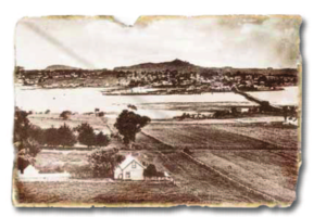 Photo of Onehunga before urbanisation.
 1859 map of Onehunga and nearby volcanoes.
With the arrival of the Europeans, settlement of the Manukau Harbour area was begun from and long focused on Onehunga. Raiding of enemy settlements also occurred from here as a base during the Māori Wars.[7] This was due to the town initially having been founded as a fencible settlement by Governor Grey, i.e. where former soldiers (mostly Irish) were granted land to settle down, with the implied understanding that if the town was threatened, they would defend it. However, by the time war actually occurred, it was mostly fought with regular soldiers.[6]
During the 19th century most shipping between New Zealand and Great Britain came to Onehunga, via South Africa and Australia. While some shipping entered the Waitemata Harbour and docked at Auckland, much of it entered the Manukau Heads and docked at Onehunga, thus saving several days sailing around North Cape.[6]
Onehunga was also the main route to and from the south, as most shipping routes were shorter via the western coast of the North Island than around the east coast to the Waitemata Harbour. Until 1908 a steamer from Onehunga was the fastest means of travel from Auckland to Wellington, the capital of the colony (initially the sea journey went all the way, then later it connected to the New Plymouth Express instead).[6][8] In 1909 a typical coastal freight connection was a steamer from Onehunga to locations like Raglan, Kawhia and Waitara,[9]
In 1874 the town had 2,044 inhabitants, compared with Wellington's 10,547, reflecting the importance of the smaller port towns during an age when New Zealand was booming, but internal transport links were still rudimentary.[10] In 1876, Onehunga was declared a borough with a mayor and 16 councillors.[6]
From 1885 on, the town became known for its wool industry, which saved it from more serious decline when the shipping trade reduced after 1908. However, it also started to suffer from the toxic discharges the freezing works at Westfield and Southdown pumped into the local part of the harbour.[6]
In 1893 Elizabeth Yates became mayor of Onehunga. While she was defeated at the polls only one year later, she was the first woman in the British Empire to hold such a post.[11]
Merging with Auckland
While in 1891 Onehunga was one of the "25 most populous urban areas/towns of New Zealand", with about 5,000 inhabitants,[12] by the First World War it had ceased to be a port of importance. It gained a new role as a shopping and service centre as it was engulfed by the suburban development of Auckland, and was amalgamated with Auckland City in 1989.[citation needed]
Onehunga had for a short time Auckland's first zoo. However, the zoological garden that John James Boyd created near today's Royal Oak did not meet with local approval - mainly due to concerns about the smells and crowds. Ten years after its 1912 opening, the animals were bought and transferred to the new Auckland Zoo at Western Springs.[13]
Although the area was a predominantly working-class suburb for much of the 20th century, it has undergone some gentrification since the 1990s.[14] In recent times, many of the bungalows of the 1920s (along with the earlier villas) have undergone restoration and Dressmart has reinvigorated commerce in the area. Secondary schools located conveniently are Onehunga High School, One Tree Hill College and Marcellin College.
The hit TV show Back Of The Y was filmed in 'Auckland's beautiful Onehunga'.
 The current (2009) foreshore, dominated by man-made breakwaters and thus relatively inhospitable.
Foreshore
Onehunga's shore is heavily modified by human use. The old volcanic basin that used to link to the Manukau Harbour was filled in, with shorelines reclaimed and straightened for human use (Port of Onehunga, industrial uses and sports fields). Later on, the New Zealand State Highway 20 extension further disrupted Onehunga's connection to the shore in the 1970s.[15]
This loss of amenity and space was one of the major complaints of local groups during negotiations over further motorway widening connected to the Mangere Bridge duplication. Proponents of a restored beach eventually won a $18 million commitment from Transit New Zealand (now New Zealand Transport Agency), which was topped up by a further $10 million from Auckland City Council. The sum is to fund a large-scale new shoreline west of the motorway, connected to downtown Onehunga with new pedestrian/cyclebridges, and creating 11ha of new beach and headland landscape. Three designs out of seven initial competitors have been shortlisted for further work as of late 2009, and it is hoped to complete the restoration of the foreshore by mid 2014.[16]
In mid 2011, the plans for the restoration works were clarified further, and provided for public comment, setting out a 6.4 hectare reclamation area with sanded beaches, new green opene space and several new headlands. The area is to receive a new boat ramp, and walk and cycleways including a new walking and cycling bridge over the motorway to Onehunga. Construction is now planned to start 2012.[15]
Sport
Onehunga is home to Onehunga Sports who compete in the Lotto Sport Italia NRFL Premier.[citation needed]
Transport
The Onehunga branch railway line opened in 1873 and was one of the first railways in New Zealand built by provincial government. Passenger services ran on the line for 100 years until April 1973. A limited number of freight services continued to use the line until 2006 when the line was mothballed. In late 2006 the Government announced approval for $10 million to be spent on reopening the line. Passenger services resumed on 19 September 2010.[17][18] The Campaign for Better Transport is currently campaigning to have the line extended south across the proposed new SH20 Manukau Harbour second crossing bridge to Auckland International Airport. Auckland's Mayor Len Brown has also campaigned for such an airport rail link, though it will likely only (be able to) happen after a CBD rail link is completed.
Queen St, named after Queen Victoria and renamed Onehunga Mall in the early 1970s, led onto the 1920s Mangere Bridge and thence to the suburb of the same name. This was one of the main land routes south out of Auckland and the usual route to the airport until the motorway & regional road system in the 1970s diverted the through traffic away from the Onehunga and Mangere Bridge.
Until 1956, a tram line ran all the way from the Auckland CBD to Onehunga.[6]
Notable buildings
 Onehunga Mall, the main street of the Onehunga town centre.
 The former post office.
- Former Post Office, 1902 John Campbell Government Architect. Princes Street & Onehunga Mall. One of the earliest examples of the work of this prolific architect.
- Anglican Church of St Peter, Onehunga Mall & Church Sts. The Selwyn church built in 1848 has been relocated, the existing building dates from the 1980s and incorporates a gothic revival tower from the 1930s. The churchyard contains the graves of many of Onehunga's early settlers.
- The Carnegie Free Library in Princes Street opened in 1912. It was one of eighteen in New Zealand built with funds from the American philanthropist Andrew Carnegie. Its services were eventually absorbed into the public library system and the building has recently been renovated as a restaurant.
- Roman Catholic Church of the Assumption Church & Galway Streets 1889, Thomas Mahoney architect. Once standing in open countryside this is a handsome example of a masonry Gothic church. The cemetery contains the graves of may of Onehunga's early settlers.
- War Memorial Arch, Jellicoe Park, Quadrant Road & Grey Street. Opened in 1923 by the Governor General, Lord Jellicoe, Jellicoe Park is the site of Onehunga's Public Swimming Pools. Near the War Memorial Arch is located the splendid John Park Memorial Fountain which is illuminated on special occasions.
Also in Jellicoe Park is a collection of buildings illustrating the early history of the area:
- The Blockhouse 1859, a brick building relocated from Princes St.
- Journeys End a replica of a wooden 1850 house, relocated here in 1968,
- Laishley House 1859, relocated from Princes St in 1985,
- Selwyn St Settlers Cottage 1850.
Across Grey Street from the park is
- St Peter's Scout Den. This is the 1848 Selwyn Church, relocated here in 1980.
Nearby in Selwyn Street is
- The former Onehunga Primary School 1901, now a community centre this building has been recently restored.
- The former Onehunga railway station building, relocated to 38 Alfred Street, headquarters of the Railway Enthusiasts Society Inc.
See also
- Onehunga Railway Branch
- Port of Onehunga
References
- ^ a b Discover Onehunga (from the 'onehunga.net.nz' website. Accessed 2008-02-10)
- ^ Uses of the volcanic field (from the 'Volcanoes of Auckland' webpage of the Auckland Regional Council. Accessed 2008-02-12.)
- ^ One Tree Hill - Use and value (from the 'Volcanoes of Auckland' webpage of the Auckland Regional Council. Accessed 2008-02-12.)
- ^ Water Supply (from the WaterCare Services Limited website. Accessed 2008-02-10)
- ^ Preparatory work starts on Onehunga duplication - The New Zealand Herald, Wednesday 01 october 2008, Page A7
- ^ a b c d e f g "Auckland: Soldiers of fortune". The New Zealand Herald. 26 August 2010. http://www.nzherald.co.nz/panmure/news/article.cfm?l_id=356&objectid=10667027. Retrieved 5 February 2011.
- ^ Manukau Harbour - European Settlement (from Te Ara Encyclopedia of New Zealand. Retrieved 2008-01-10.)
- ^ The era of steam - Saving time (from Te Ara Encyclopedia of New Zealand. Retrieved 2008-03-10.)
- ^ Page 4 Advertisements Column 2 (from the Hawera & Normanby Star, Volume LVIII, Issue LVIII, 26 January 1910, via the National Library website. Accessed 2008-03-10.)
- ^ New Zealand Historical Atlas - McKinnon, Malcolm (Editor); David Bateman, 1997, Plate 53
- ^ Mogford, Janice C.. "Yates, Elizabeth 1840-1848?–1918". Dictionary of New Zealand Biography. Ministry for Culture and Heritage. http://www.teara.govt.nz/en/biographies/2y1. Retrieved 7 April 2011.
- ^ New Zealand Historical Atlas - McKinnon, Malcolm (Editor); David Bateman, 1997, Plate 65
- ^ How it all began... (from the Auckland Zoo website. Accessed 2008-03-10.)
- ^ South-Eastern Suburbs: Industrial Heartland (from Te Ara Encyclopedia of New Zealand. Retrieved 2011-03-31.)
- ^ a b "Onehunga Foreshore". Our Auckland. Auckland Council: p. 4. July 2011.
- ^ "$28m to rejuvenate Onehunga Bay". The New Zealand Herald. 29 December 2009. http://www.nzherald.co.nz/nz/news/article.cfm?c_id=1&objectid=10617681&pnum=0. Retrieved 20 March 2010.
- ^ Kathryn Powley and Emma Geraghty (19 September 2010). "People turn out to show car not the only way to travel". The New Zealand Herald. http://www.nzherald.co.nz/transport/news/article.cfm?c_id=97&objectid=10674505. Retrieved 1 November 2011.
- ^ Onehunga Line Timetable, from 19 September 2010. Retrieved 19 September 2010.
- The Lively Capital, Auckland 1840-1865. Una Platts. Avon Fine Prints Limited New Zealand 1971.
- Onehunga Art & Heritage Walks, Onehunga Mainstreet Programme 2003.
Coordinates: 36°55′20″S 174°47′02″E / 36.9223°S 174.7838°E
External links
- [1] Discover Onehunga - all about Onehunga (site maintained by Onehunga Business Association)
Categories:- Suburbs of Auckland
- Port cities in New Zealand


Wikimedia Foundation. 2010.