- East Point Light
-
East Point Light 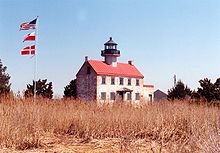
East Point Light Location Rural Cumberland County, near Heislerville, New Jersey Coordinates 39°11′45″N 75°01′38″W / 39.19583°N 75.02722°W Year first lit 1849 Automated 1911 Deactivated 1941-1980 Foundation Stone Construction Brick Tower shape Octagonal on roof of rectangular building Height 40 feet (12.2 m) Original lens Sixth order Fresnel lens Characteristic Maurice River Lighthouse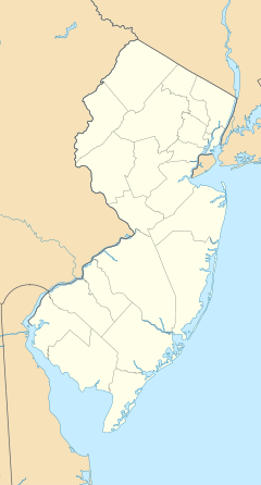

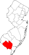
Location: Lighthouse Rd., near the jct. of East Point Rd., Maurice River Township, New Jersey Coordinates: 39°11′45″N 75°1′40″W / 39.19583°N 75.02778°WCoordinates: 39°11′45″N 75°1′40″W / 39.19583°N 75.02778°W Area: 3.6 acres (1.5 ha) Built: 1849 Architect: Middleton, N. & S. Governing body: State NRHP Reference#: 95001047[1] NJRHP #: [2] Added to NRHP: August 25, 1995 The East Point Light, formerly named Maurice River Light, is a lighthouse located in Heislerville, New Jersey on Delaware Bay at the mouth of the Maurice River. Initially known as the Maurice River Light, the name was changed to East Point Light in 1913. The light was inactive from 1941 and was nearly destroyed by fire in 1971. The light was reinstated by the United States Coast Guard in 1980. Exterior restoration was completed in 1999.
Listed in the National Register of Historic Places as Maurice River Lighthouse, reference #95001047.
Contents
See also
References
- ^ "National Register Information System". National Register of Historic Places. National Park Service. 2009-03-13. http://nrhp.focus.nps.gov/natreg/docs/All_Data.html.
- ^ "New Jersey and National Registers of Historic Places - Cumberland County". NJ DEP - Historic Preservation Office. April 1, 2010. p. 12. http://www.state.nj.us/dep/hpo/1identify/lists/cumberland.pdf. Retrieved October 13, 2010.
Specialized Further reading
- NPS - East Point Light at Historic light stations
- "Historic Light Station Information and Photography: New Jersey". United States Coast Guard Historian's Office. http://www.uscg.mil/history/weblighthouses/LHNJ.asp.
- East Point Light - from Lighthousefriends.com
- For history, pictures, directions and opening schedule. From Maurice River Historical Society
Further reading
Lighthouses of New Jersey Absecon Light • Barnegat Lighthouse • Brandywine Shoal Light • Brigantine Lighthouse • Cape May Light • Chapel Hill Rear Range Light • Conover Beacon • Cross Ledge Light • East Point Light • Elbow of Cross Ledge Light • Finns Point Range Light • Great Beds Light • Hereford Inlet Light • Ludlam's Beach Light • Miah Maull Shoal Light • Navesink Twin Lights • Robbins Reef Light • Romer Shoal Light • Sandy Hook Light • Sea Girt Light • Ship John Shoal Light • Tinicum Island Rear Range Light
U.S. National Register of Historic Places Topics Lists by states Alabama • Alaska • Arizona • Arkansas • California • Colorado • Connecticut • Delaware • Florida • Georgia • Hawaii • Idaho • Illinois • Indiana • Iowa • Kansas • Kentucky • Louisiana • Maine • Maryland • Massachusetts • Michigan • Minnesota • Mississippi • Missouri • Montana • Nebraska • Nevada • New Hampshire • New Jersey • New Mexico • New York • North Carolina • North Dakota • Ohio • Oklahoma • Oregon • Pennsylvania • Rhode Island • South Carolina • South Dakota • Tennessee • Texas • Utah • Vermont • Virginia • Washington • West Virginia • Wisconsin • WyomingLists by territories Lists by associated states Other National Register of Historic Places in Cumberland County, New Jersey Historic districts Bridgeton Historic District | Greenwich Historic District
Other properties A. J. Meerwald | Beth Hillel Synagogue | Bethel African Methodist Episcopal Church | Bivalve Oyster Packing Houses and Docks | Jeremiah Buck House | Deerfield Pike Tollgate House | Deerfield Presbyterian Church | Gen. James Giles House | Caesar Hoskins Log Cabin | Landis School (originally Vineland High School) | Landis Theatre-Mori Brothers Building | Levoy Theatre | Thomas Maskel House | East Point Light | Miah Maull Shoal Light | Millville's First Bank Building | Old Broad Street Presbyterian Church and Cemetery | Old Stone Church | Potter's Tavern | Samuel W. Seeley House | Ship John Shoal Light | Spindrift Sailing Yacht | Trinity African Methodist Episcopal Church
Categories:- 1849 establishments
- Lighthouses on the National Register of Historic Places
- Lighthouses in New Jersey
- National Register of Historic Places in New Jersey
- Buildings and structures completed in 1849
- Museums in Cumberland County, New Jersey
- Lighthouse museums in New Jersey
- New Jersey building and structure stubs
- United States lighthouse stubs
- New Jersey Registered Historic Place stubs


Wikimedia Foundation. 2010.