- Choptank River
-
Choptank River  The river in Denton, MD.
Country  United States
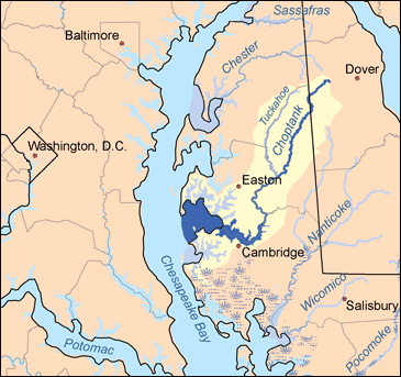
States Maryland, Delaware Tributaries - right Tuckahoe Creek Cities Cambridge, Denton Source Choptank Mills Mouth Chesapeake Bay - location Algonquin, Maryland - elevation 0 ft (0 m) - coordinates 38°36′14.9″N 76°04′53.6″W / 38.604139°N 76.081556°W Length 71 mi (114 km) Basin 1,004 sq mi (2,600 km2)  Map of the rivers of the Eastern Shore of Maryland with the Choptank and its watershed highlighted.
The Choptank River is a major tributary of the Chesapeake Bay on the Delmarva Peninsula. Running for 71 miles (114 km),[1] it rises in Kent County, Delaware, runs through Caroline County, Maryland and forms much of the border between Talbot County, Maryland on the north, and Caroline County and Dorchester County on the east and south. It is located north of the Nanticoke River and its mouth is located south of Eastern Bay. Cambridge, the county seat of Dorchester County, and Denton, the county seat of Caroline County, are located on its south shore.
Its watershed area in Maryland is 1,004 square miles (2,600 km2), of which 224 square miles (580 km2) is open water, so it is 22% water. The predominant land use is agricultural with 418 square miles (1,080 km2), or 48% of the land area.
Contents
Course
The Choptank River begins at Choptank Mills, Delaware, where Tidy Island Creek and Culbreth Marsh Ditch join together. It ends at the Chesapeake Bay in a very wide mouth between Blackwalnut Point on Tilghman Island, and Cook Point, near Hudson, Maryland. Tidy Island Creek and Culbreth Marsh Ditch rise in western Kent County, Delaware. The entire watershed is in the coastal plain. The Choptank reaches sea level near Denton, Maryland and is not salty until around 2 miles (3.2 km) below Denton. Greensboro, Maryland, about 6 miles (9.7 km) up the river from Denton, is the head of navigation.
Tributaries
Its main tributaries are the Tred Avon River and Tuckahoe Creek on the north side and Cabin Creek and Hunting Creek on the south side.
There are several small creeks on the northern shore, including Harris Creek, Broad Creek, Irish Creek, Island Creek, La Trappe Creek, Bolingroke Creek, Mile Creek, Kings Creek, Forge Branch and Broadway Branch. On the southern shore the small creeks include Jenkins Creek, the Warwick River, Marsh Creek, Maryland, Skeleton Creek, Mitchell Run, Hog Creek, Fowling Creek, Robins Creek, Williston Creek, Watts Creek, Chapel Branch, Spring Branch, Gravelly Branch and Cow Marsh Creek.[citation needed]
See also
- List of rivers of Delaware
- List of rivers of Maryland
- Choptank Indian Tribe
References
- ^ U.S. Geological Survey. National Hydrography Dataset high-resolution flowline data. The National Map, accessed April 1, 2011
- United States Geological Survey. 7.5 minute series topographic quadrangles.
- Chesapeake Bay Program Watershed Profile: Choptank River
Waters of Maryland Bays/Estuaries Assawoman • Chesapeake • Chincoteague • Eastern • Fishing • Herring • Isle of Wight • Mallows • Newport • Pocomoke • Sinepuxent • TangierRivers Anacostia • Annemessex (Big) • Annemessex (Little) • Back • Bird • Blackwater • Blackwater (Little) • Bohemia • Bush • Casselman • Chester • Chicamacomico • Choptank • Choptank (Little) • Christina River • Corsica • Elk • Front • Gunpowder • Hawlings • Jones Falls • Magothy • Magothy (Little) • Manokin • Middle • Miles • Monocacy • Monocacy (Little) • Nanticoke • North East • Patapsco • Patuxent • Pocomoke • Port Tobacco • Potomac • Rhode • St. Martin • St. Marys • Sassafras • Savage • Severn • South • Susquehanna • Transquaking • Tred Avon • Warwick • West • Wicomico (Potomac) • Wicomico • Wye • Wye East • YoughioghenyCreeks/Runs/Streams Antietam • Alloway • Ballenger • Bear (Patapsco) • Bear (Sideling Hill) • Bear (Youghiogheny) • Bennett • Big Pipe • Bodkin • Bread and Cheese • Broad (Choptank) • Broad (Potomac) • Broad (Susquehanna) • Broad Run • Budds • Cabin John • Carroll • Catoctin • Catoctin (Little) • Chicamuxen • Conococheague • Conococheague (Little) • Conowingo • Cuckold • Curtis • Deep Run • Deer • Dividing • Double Pipe • Dry Seneca • Dueling • Dundee • Evitts • Fifteenmile • Fishing • Flintstone • Frog Mortar • Furnace • Georges • Great Seneca • Greys • Gwynns Falls • Harris • Henson • Herring Run • Honga • Indian (Anacostia) • Indian (Patuxent) • Israel • Laurel Run • Licking • Linganore • Little Falls Branch • Little Pipe • Little Seneca • Lyons • Main • Marley • Marsh • Marshyhope • Mattawoman • Meekins • Middle • Minnehaha Branch • Moores Run • Muddy Branch • Nanjemoy • Nassawango • Northeast Branch Anacostia River • Northwest Branch Anacostia River • Octoraro • Owens • Oxon • Paint Branch • Parsons • Piney • Piscataway • Pomonkey • Rock (Potomac) • Rock Run • Rockburn Branch • Romney • St. Leonard • Saltpeter • Sams Creek • Sellman • Seneca (Middle) • Seneca (Potomac) • Sideling Hill • Slaughter • Sligo • Stony • Swanson • Toms • Tonoloway • Town (Patuxent) • Town (Potomac) • Town (Tred Avon) • Trappe • Tuckahoe • Turville • Tuscarora (Monocacy) • Tuscarora (Potomac) • Tuscarora (Little) • Watts Branch • Wills • Winters RunLakes Artemesia • Centennial • Deep Creek • Elkhorn • Bernard Frank • Jennings Randolph • Kittamaqundi • Little Seneca • Needwood • Roland • YoughioghenyReservoirs Categories:- Chesapeake Bay Watershed
- Rivers of Delaware
- Rivers of Maryland
- Geography of Caroline County, Maryland
- Landforms of Kent County, Delaware

Wikimedia Foundation. 2010.