- Delaware Route 71
-
Delaware Route 71
Route information Maintained by DelDOT and USACE Length: 21.99 mi[1] (35.39 km) Major junctions South end:  US 13 south of Townsend
 DE 299 in Middletown
 US 301 in Middletown
 DE 896 in Mount Pleasant
 DE 15 in Summit
US 301 / DE 896 north of Summit
 DE 72 near Red Lion
 DE 7 in Red Lion
North end:  US 13 / DE 1 in Tybouts Corner
Highway system ←  DE 62
DE 62DE 72 →Delaware Route 71 (DE 71) is a state highway in New Castle County, Delaware. The route loops off U.S. Route 13 (US 13) from south of Townsend to Tybouts Corner, traveling to the west of US 13 by way of Townsend, Middletown, and the Summit Bridge. The route overlaps US 301 from the north end of Middletown to just north of the Summit Bridge, and also with DE 896 from Mount Pleasant to just north of the Summit Bridge, where US 301 and DE 896 continue north together to Glasgow.
DE 71 was built as a state highway during the 1920s and 1930s. By 1938, the route was designated to run from US 13 south of Townsend to US 13 in Tybouts Corner roughly along its present-day alignment. In the 1950s, DE 71 was rerouted to head to the Maryland border southwest of Middletown, with the former route south of Middletown becoming an extended DE 896. Between the 1950s and 1980s, DE 71 was signed with various alignments of US 301 and US 301S. In the 1980s, DE 71 was truncated to DE 896 in Summit Bridge before being extended back along its 1930s alignment to US 13 by the 1990s.
Contents
Route description
DE 71 heads to the northwest from US 13 on two-lane undivided Summit Bridge Road, passing through wooded areas with some homes. The road passes to the east of Townsend and interesects Pine Tree Road/Main Street near some businesses. Past Townsend, the route continues northwest into farmland, making a turn to the north.[1][2] At the intersection with St. Anne's Church Road, Delaware Bicycle Route 1 (Bike Route 1) turns north to join DE 71.[3] DE 71 enters areas of increasing residential development as it heads into the town of Middletown, where it becomes Broad Street. The road heads north through the town and intersects DE 299 (Main Street) in the commercial center of town.[1][2] Here, Bike Route 1 turns west onto DE 299.[3] From this point, the route passes more homes before passing near businesses. DE 71 crosses Norfolk Southern's Delmarva Secondary at-grade and intersects US 301 immediately after.[1][2]
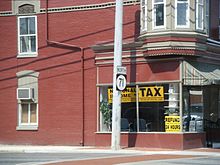 DE 71 northbound past DE 299 in Middletown
DE 71 heads north concurrent with US 301 on Summit Bridge Road, passing near some businesses and a housing development before leaving Middletown. The road runs a short distance to the west of the Norfolk Southern rail line as it continues farmland with some scattered residential and commercial development. In Mount Pleasant, DE 896 joins US 301/DE 71 from the east and the road widens from a two-lane undivided road to a four-lane, divided highway. The road passes a few businesses before heading between the Summit Airport to the west and housing developments to the east. US 301/DE 71/DE 896 heads to the northwest through farm fields before turning to the west and passing a residential subdivision to the south.[1][2] In the unincorporated community of Summit, the road intersects the northern terminus of DE 15, where Bike Route 1 joins the road again.[3][4] Past this intersection, US 301/DE 71/DE 896 turns north and crosses over the Chesapeake and Delaware Canal on the Summit Bridge.[1][2]
Past the Summit Bridge, the road passes through woods and passes under Chesapeake City Road near the Delaware Veterans Memorial Cemetery. DE 71 splits from US 301/DE 896 and Bike Route 1 by heading to the southeast on two-lane undivided Red Lion Road. The road passes a mix of woods and homes as it becomes the southern boundary of Lums Pond State Park and turns east into woodland. The route turns northeast through more of the state park before entering into a mix of farmland and homes. DE 71 passes through the community of Kirkwood and crosses the Norfolk Southern Delmarva Secondary again, continuing into wooded areas of suburban residential development, crossing DE 72. The route continues northeast near a mix of farms and woods with some homes, crossing Norfolk Southern's Delaware City Secondary. From here, the road passes more suburban residences and reaches the community of Red Lion, where it crosses DE 7. The final stretch of DE 71 heads northeast past more housing subdivisions toward its northern terminus at US 13 in Tybouts Corner. This intersection is within an interchange between US 13 and DE 1, where DE 1 merges off US 13. Direct access is provided from southbound DE 1 to DE 71 just before the intersection with US 13.[1][2]
History
What is now DE 71 originally existed as a county road by 1920, with the portion south of Townsend proposed as a state highway at this time.[5] By 1924, the entire length of the present route was paved, with the portion from the Summit Bridge to Kirkwood proposed as a state highway and the portion from Kirkwood to Tybouts Corner improved to a state highway.[6] A year later, the state highway had been completed south of Townsend and between Mt. Pleasant and Kirkwood.[7] By 1931, the remainder became a state highway.[8] When Delaware started numbering state highways by 1936, this road remained unnumbered.[9] By 1938, DE 71 was designated to run from US 13 south of Townsend north to US 13 in Tybouts Corner, following roughly the same alignment it does today.[10]
By 1957, DE 71 was to follow DE 299 southwest from Middletown before splitting from that route and reaching the Maryland border, where it connected to MD 71. Also, DE 896 was extended south from Summit Bridge to follow DE 71 to Middletown and then continue along the former DE 71 through Townsend to US 13.[11] By 1959, US 301 was designated along DE 71/DE 299 between the Maryland border and Middletown and US 301S was designated along DE 71 from Middletown to Tybouts Corner.[12] The route was realigned to a new Summit Bridge a short distance to the west in 1960, following new roads that led to the bridge. As a result of this, US 301S/DE 71 was designated onto a former piece of DE 896 between the new alignment and Red Lion Road to the east, with the rest of the former alignment becoming a dead end road south to the canal and the former alignment south of the canal becoming a local road serving the community of Summit.[12][13] By 1971, US 301 was shifted to follow what had been US 301S between Middletown and Summit Bridge, with US 301S remaining along DE 71 between Summit Bridge and Tybouts Corner.[14] By 1984, DE 896 was rerouted to run from Mount Pleasant to Boyds Corner, with the route being removed from DE 71 from Mt. Pleasant to Middletown and the segment from Middletown to south of Townsend, which was the original routing of DE 71, becoming unnumbered.[15] A year later, US 301N was rerouted onto the newly aligned DE 896 and US 13 between Mt. Pleasant and Tybouts Corner and US 301S was extended south along DE 71/DE 896 from Summit Bridge to Mt. Pleasant.[16] DE 71 was truncated to Summit Bridge by 1987, also at which time US 301S was removed from DE 71.[17] By 1990, DE 71 was extended back south along its original alignment to again end at US 13 south of Townsend.[18] US 301 was realigned to follow the route between Mt. Pleasant and Summit Bridge by 1994.[19]
Major intersections
The entire route is in New Castle County.
Location Mile[1] Road Notes Townsend 0.00 US 13 (Dupont Parkway)Southern terminus Middletown 5.73 DE 299 (Main Street) US 301 south (Peterson Road)South end of US 301 concurrency Mount Pleasant 10.04 DE 896 south (Boyds Corner Road) to US 13 / DE 1 – Dover, BeachesSouth end of DE 896 concurrency Summit Bridge 12.19 DE 15 south (Bethel Church Road)Summit Bridge over the Chesapeake and Delaware Canal 14.14 US 301 / DE 896 north (Summit Bridge Road)North end of US 301/DE 896 concurrency Wrangle Hill 18.84 DE 72 (Wrangle Hill Road)Bear 20.75 DE 7 (Bear Corbit Road)21.99 US 13 (Dupont Highway) / DE 1Interchange, northern terminus 1.000 mi = 1.609 km; 1.000 km = 0.621 mi See also
 U.S. Roads portal
 Delaware portal
References
- ^ a b c d e f g h "Traffic Count and Mileage Report: Interstate, Delaware, and US Routes" (PDF). Delaware Department of Transportation. 2008. http://deldot.gov/information/pubs_forms/manuals/traffic_counts/2008/pdf/TRAFFICBOOK_RTES.pdf. Retrieved 2010-04-15.
- ^ a b c d e f Google, Inc. Google Maps – overview of Delaware Route 71 (Map). Cartography by Google, Inc. http://maps.google.com/maps?f=d&source=s_d&saddr=US+13+and+DE+71+townsend&daddr=39.4207,-75.70571+to:39.4564871,-75.7188985+to:39.48821,-75.71743+to:39.538881,-75.7378992+to:dupont+parkway+and+DE+71+tybouts+corner&geocode=FVrmWAIdqHB9-yn7B8xo_nTHiTHlR84B9GP0vA%3BFRyDWQIdktJ8-yn1QfWtU3XHiTGmgiG3SzW6Jw%3BFecOWgIdDp98-ylL7E-ReaDHiTEyXBQYOHJGgw%3BFdKKWgIdyqR8-ynjBBG-oaDHiTF0hE-tG2vwyA%3BFcFQWwId1VR8-ykFuHLLbKfHiTF1ttDkNjWG6w%3BFbCDXAId0sF9-ykrRl7_XwbHiTH2QQqUntqWig&hl=en&mra=ls&via=1,2,3,4&sll=39.604366,-75.645161&sspn=0.06031,0.169086&ie=UTF8&t=h&z=11. Retrieved February 6, 2011.
- ^ a b c Delaware Department of Transportation (PDF). New Castle County Delaware Bicycle Map (Map) (2008 ed.). http://www.deldot.gov/information/community_programs_and_services/bike/pdf/maps/NewCastle.pdf. Retrieved March 1, 2011.
- ^ Delaware Department of Transportation (PDF). Delaware Official Highway Map (Map) (2008 ed.). http://www.deldot.gov/archaeology/historic_pres/historic_highway_maps/pdf/cd_083.pdf. Retrieved 2010-08-02.
- ^ Delaware Department of Transportation (PDF). Delaware Official Highway Map (Map) (1920 ed.). http://www.deldot.gov/archaeology/historic_pres/historic_highway_maps/pdf/cd_002.pdf. Retrieved April 15, 2010.
- ^ Delaware Department of Transportation (PDF). Delaware Official Highway Map (Map) (1924 ed.). http://www.deldot.gov/archaeology/historic_pres/historic_highway_maps/pdf/cd_003.pdf. Retrieved August 1, 2010.
- ^ Delaware Department of Transportation (PDF). Delaware Official Highway Map (Map) (1925 ed.). http://www.deldot.gov/archaeology/historic_pres/historic_highway_maps/pdf/cd_004.pdf. Retrieved August 19, 2010.
- ^ Delaware Department of Transportation (PDF). Delaware Official Highway Map (Map) (1931 ed.). http://www.deldot.gov/archaeology/historic_pres/historic_highway_maps/pdf/cd_005.pdf. Retrieved 2010-08-19.
- ^ Delaware Department of Transportation (PDF). Delaware Official Highway Map (Map) (1936/37 ed.). http://www.deldot.gov/archaeology/historic_pres/historic_highway_maps/pdf/cd_008.pdf. Retrieved April 15, 2010.
- ^ Delaware Department of Transportation (PDF). Delaware Official Highway Map (Map) (1938 ed.). http://www.deldot.gov/archaeology/historic_pres/historic_highway_maps/pdf/cd_010.pdf. Retrieved February 6, 2011.
- ^ Delaware Department of Transportation (PDF). Delaware Official Highway Map (Map) (1957/58 ed.). http://www.deldot.gov/archaeology/historic_pres/historic_highway_maps/pdf/cd_030.pdf. Retrieved April 29, 2010.
- ^ a b Delaware Department of Transportation (PDF). Delaware Official Highway Map (Map) (1959/60 ed.). http://www.deldot.gov/archaeology/historic_pres/historic_highway_maps/pdf/cd_032.pdf. Retrieved April 15, 2010.
- ^ "U.S. Army Corps of Engineers to intermittently close the Chesapeake City Bridge during testing" (PDF). United States Army Corps of Engineers. September 22, 2005. http://www.nap.usace.army.mil/cenap-pa/U%20S%20%20Army%20Corps%20of%20Engineers%20to%20intermittently%20close%20the%20Chesapeake%20City%20Bridge%20during%20testing%20Sept%202005.pdf. Retrieved February 6, 2011.
- ^ Delaware Department of Transportation (PDF). Delaware Official Highway Map (Map) (1971 ed.). http://www.deldot.gov/archaeology/historic_pres/historic_highway_maps/pdf/cd_050.pdf. Retrieved April 15, 2010.
- ^ Delaware Department of Transportation (PDF). Delaware Official Highway Map (Map) (1984 ed.). http://www.deldot.gov/archaeology/historic_pres/historic_highway_maps/pdf/cd_062.pdf. Retrieved February 5, 2011.
- ^ Delaware Department of Transportation (PDF). Delaware Official Highway Map (Map) (1985 ed.). http://www.deldot.gov/archaeology/historic_pres/historic_highway_maps/pdf/cd_060.pdf. Retrieved April 15, 2010.
- ^ Delaware Department of Transportation (PDF). Delaware Official Highway Map (Map) (1987 ed.). http://www.deldot.gov/archaeology/historic_pres/historic_highway_maps/pdf/cd_064.pdf. Retrieved February 6, 2011.
- ^ Delaware Department of Transportation (PDF). Delaware Official Highway Map (Map) (1990 ed.). http://www.deldot.gov/archaeology/historic_pres/historic_highway_maps/pdf/cd_070.pdf. Retrieved February 6, 2011.
- ^ Delaware Department of Transportation (PDF). Delaware Official Highway Map (Map) (1994 ed.). http://www.deldot.gov/archaeology/historic_pres/historic_highway_maps/pdf/cd_068.pdf. Retrieved April 29, 2010.
External links
 Media related to Delaware Route 71 at Wikimedia Commons
Road transportation infrastructure of the metro Philadelphia area Interstates U.S. Routes Pennsylvania Routes New Jersey Routes Delaware Routes Named roads/streets Benjamin Franklin Parkway · Broad Street · City Avenue · Front Street · Girard Avenue · Market Street · Roosevelt Boulevard · South Street · Chestnut Street · Walnut Street
Pennsylvania Turnpike · New Jersey Turnpike · Delaware Turnpike · Atlantic City Expressway · Schuylkill Expressway · Delaware Expressway · Blue Route · Vine St Expressway · North South Freeway · Lancaster Avenue · Bethlehem Pike · Baltimore Pike · Black Horse PikeBridges Delaware Memorial Bridge · Commodore Barry Bridge · Walt Whitman Bridge · Ben Franklin Bridge · Betsy Ross Bridge · Tacony–Palmyra Bridge · Burlington–Bristol Bridge · Delaware River – Turnpike Toll BridgeCategories:- State highways in Delaware
- Transportation in New Castle County, Delaware


Wikimedia Foundation. 2010.