Oranga

Oranga
Oranga
Basic information
Local authority Auckland City
Facilities
Surrounds
North Greenlane
Northeast Ellerslie
East Penrose
Southeast Te Papapa
South Onehunga
Southwest Onehunga
West Royal Oak
Northwest One Tree Hill
v · d · e
The Oranga Community Centre.
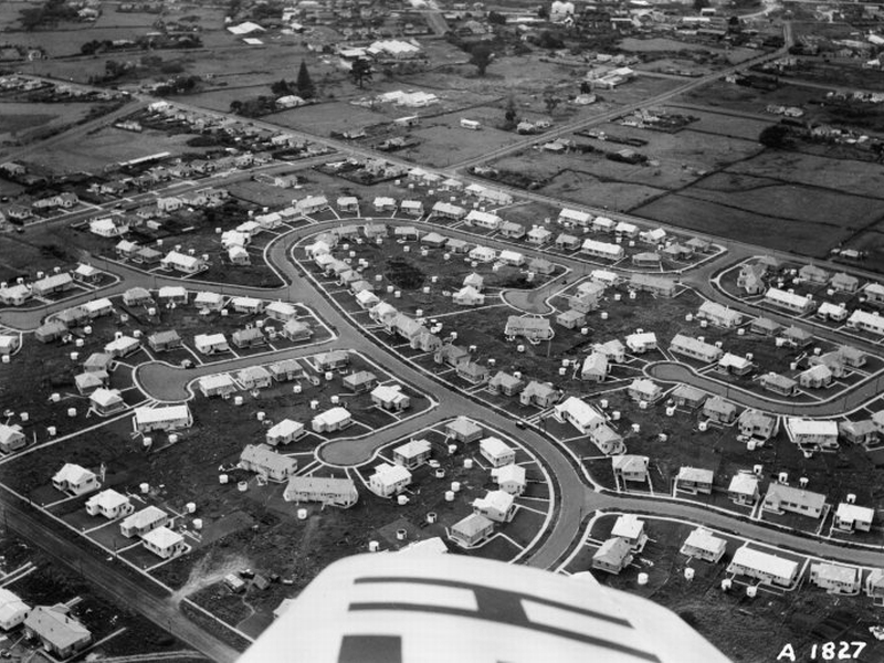
State houses in the 'Harp of Erin' estate in Oranga, seen in 1947. Note the typical suburban cul-de-sac layout.

Oranga is a small residential suburb in Auckland, New Zealand. It is located nine kilometres to the southeast of the city centre, between the commercial suburbs of Te Papapa and Penrose to the south and east, and the residential suburbs of One Tree Hill and Onehunga to the north and south, with which it is frequently confused. The name is from a Maori word, Oranga (noun) - meaning 'survivor, food, livelihood, welfare, health, living' [1]

It used to be a state housing neighbourhood for low-income families, but it is rapidly gentrifying. Private investors have bought up many of the state houses for renovation, and to subdivide their generous sections. Real estate agents increasingly advertise these houses as belonging to the wealthier suburb of One Tree Hill.

Local facilities include Oranga Kindergarten (neighbouring Fergusson Domain), and Oranga Primary School.[2] The local Secondary schools are One Tree Hill College, Marcellin College and St Peter's College.

References


Wikimedia Foundation. 2010.

Игры ⚽ Нужна курсовая?

Look at other dictionaries:

  • State sector organisations in New Zealand — are as follows: (see also State Sector Act 1988) Parliamentary Offices * Office of the Controller and Auditor General (Tumuaki o te Mana Arotake) ** Audit New Zealand * Office of the Ombudsmen (Nga Kaitiaki Mana Tangata) * Office of the… …   Wikipedia

  • Penrose, New Zealand — Infobox New Zealand suburbs name = Penrose caption1 = city1 = Auckland City city2 = ward = established = 1860s (Approx.) area = population = 537 popdate = 2001 trainstations = Penrose Train Station ferryterminals = airports = hospitals = north =… …   Wikipedia

  • Onehunga — For other uses, see Onehunga (disambiguation). Onehunga Onehunga Mall from near the southern end …   Wikipedia

  • nesuoranga — scom. (1); LL15 kas nerangus, nevikrus: Nesusirangęs, nesuoranga KII111 …   Dictionary of the Lithuanian Language

  • Public housing — A local authority 20 storey tower block in Cwmbrân, South Wales …   Wikipedia

  • One Tree Hill, New Zealand — Maungakiekie redirects here. For the electorate, see Maungakiekie (New Zealand electorate). One Tree Hill Maungakiekie One Tree Hill after the removal of the One Tree . The image does not show …   Wikipedia

  • Ellerslie, New Zealand — Infobox New Zealand suburbs name = Ellerslie caption1 = city1 = Auckland City city2 = ward = established = 1908 area = population = 7,263 popdate = 2001 trainstations = Ellerslie Train Station ferryterminals = airports = hospitals = north =… …   Wikipedia

  • Te Papapa — Suburb:Te PapapaCity:AucklandIsland:North IslandSurrounded by to the north to the north east to the east to the south to the south west to the west to the north west Penrose (1322 m) Mount Wellington (2.5 km) Southdown (1311 m) Favona (3.1 km)… …   Wikipedia

  • Auckland City — This article is about the former local government area. For the football team, see Auckland City FC. For the greater metropolitan area, see Auckland. Auckland City   Territorial authority of New Zealand   …   Wikipedia

  • Royal Oak, New Zealand — Suburb:Royal OakCity:AucklandIsland:North IslandSurrounded by to the north to the north east to the east to the south east to the south to the south west to the west to the north west Epsom (3.0 km) One Tree Hill (1.7 km) Oranga (1.7 km) Onehunga …   Wikipedia

Share the article and excerpts

Direct link
Do a right-click on the link above
and select “Copy Link”