- Marshall County, Indiana
-
Marshall County, Indiana 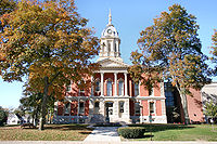 Marshal County courthouse in Plymouth, Indiana
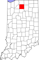
Location in the state of Indiana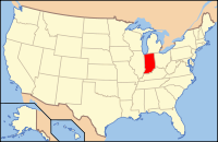
Indiana's location in the U.S.Founded 1836 Named for John Marshall Seat Plymouth Area
- Total
- Land
- Water
449.74 sq mi (1,165 km²)
443.63 sq mi (1,149 km²)
6.11 sq mi (16 km²), 1.36%Population
- (2010)
- Density
47,051
106/sq mi (40.88/km²)Congressional district 1st Time zone Eastern: UTC-5/-4 Footnotes: Indiana county number 50
Marshall County is a county located in the U.S. state of Indiana. The county seat is Plymouth[1]. Census 2010 recorded the population at 47,051.[2]
Contents
History
Marshall County was formed in 1836. It was named for U.S. Chief Justice John Marshall, who died in 1835.[3] Marshall County is notable as the starting point in 1838 of the Potawatomi Trail of Death, which was the forced removal by United States forces of 859 members of the Potawatomi nation from to the location of present-day Osawatomie, Kansas, a distance of 660 miles (1,060 km).
Geography
According to the 2010 census, the county has a total area of 449.74 square miles (1,164.8 km2), of which 443.63 square miles (1,149.0 km2) (or 98.64%) is land and 6.11 square miles (15.8 km2) (or 1.36%) is water.[4] The Yellow River flows through northern, central, and western portions of Marshall County, past Plymouth; the Tippecanoe River flows through the southeastern part of the county.[5]
Adjacent counties
- St. Joseph County (north)
- Elkhart County (northeast)
- Kosciusko County (east)
- Fulton County (south)
- Pulaski County (southwest)
- Starke County (west)
Major highways
Cities and towns
Census-designated place
Townships
Climate and weather
Plymouth, Indiana Climate chart (explanation) J F M A M J J A S O N D 2.232161.938202.94929462394.374494.583583.786623.484603.677533.264423.250322.83722Average max. and min. temperatures in °F Precipitation totals in inches Source: The Weather Channel[6] Metric conversion J F M A M J J A S O N D 550-9473-7729-210117410823911428149530178529169125128118681100713-6Average max. and min. temperatures in °C Precipitation totals in mm In recent years, average temperatures in Plymouth have ranged from a low of 16 °F (−9 °C) in January to a high of 86 °F (30 °C) in July, although a record low of −25 °F (−32 °C) was recorded in January 1985 and a record high of 109 °F (43 °C) was recorded in July 1936. Average monthly precipitation ranged from 1.86 inches (47 mm) in February to 4.48 inches (114 mm) in June.[6]
Government
See also: Government of IndianaThe county government is a constitutional body, and is granted specific powers by the Constitution of Indiana, and by the Indiana Code.
County Council: The county council is the legislative branch of the county government and controls all the spending and revenue collection in the county. Representatives are elected from county districts. The council members serve four year terms. They are responsible for setting salaries, the annual budget, and special spending. The council also has limited authority to impose local taxes, in the form of an income and property tax that is subject to state level approval, excise taxes, and service taxes.[7][8]
Board of Commissioners: The executive body of the county is made of a board of commissioners. The commissioners are elected county-wide, in staggered terms, and each serves a four-year term. One of the commissioners, typically the most senior, serves as president. The commissioners are charged with executing the acts legislated by the council, collecting revenue, and managing the day-to-day functions of the county government.[7][8]
Court: The county maintains a small claims court that can handle some civil cases. The judge on the court is elected to a term of four years and must be a member of the Indiana Bar Association. The judge is assisted by a constable who is also elected to a four-year term. In some cases, court decisions can be appealed to the state level circuit court.[8]
County Officials: The county has several other elected offices, including sheriff, coroner, auditor, treasurer, recorder, surveyor, and circuit court clerk Each of these elected officers serves a term of four years and oversees a different part of county government. Members elected to county government positions are required to declare party affiliations and to be residents of the county.[8]
Marshall County is part of Indiana's 2nd congressional district and in 2008 was represented by Joe Donnelly in the United States Congress.[9] It is also part of Indiana Senate districts 5 and 9[10] and Indiana House of Representatives districts 17 and 23.[11]
Demographics
Historical populations Census Pop. %± 1840 1,651 — 1850 5,348 223.9% 1860 12,722 137.9% 1870 20,211 58.9% 1880 23,414 15.8% 1890 23,818 1.7% 1900 25,119 5.5% 1910 24,175 −3.8% 1920 23,744 −1.8% 1930 25,077 5.6% 1940 25,935 3.4% 1950 29,468 13.6% 1960 32,443 10.1% 1970 34,986 7.8% 1980 39,155 11.9% 1990 42,182 7.7% 2000 45,128 7.0% 2010 47,051 4.3% Sources: United States Department of Commerce,
Bureau of the Census, Population Division[12]
Census Quickfacts[2]As of the census[13] of 2000, there were 45,128 people, 16,519 households, and 12,191 families residing in the county. The population density was 102 people per square mile (39/km²). There were 18,099 housing units at an average density of 41 per square mile (16/km²). The racial makeup of the county was 95.53% White, 0.30% Black or African American, 0.30% Native American, 0.31% Asian, 0.02% Pacific Islander, 2.54% from other races, and 1.01% from two or more races. 5.90% of the population were Hispanic or Latino of any race. 36.6% were of German, 14.2% American, 8.2% English and 8.0% Irish ancestry according to Census 2000.
There were 16,519 households out of which 35.80% had children under the age of 18 living with them, 61.30% were married couples living together, 8.30% had a female householder with no husband present, and 26.20% were non-families. 22.30% of all households were made up of individuals and 10.00% had someone living alone who was 65 years of age or older. The average household size was 2.69 and the average family size was 3.15.
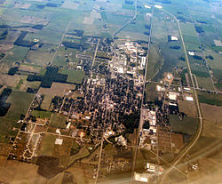 Marshall County is flat farmland dotted with small towns like Bremen.
In the county the population was spread out with 28.10% under the age of 18, 8.70% from 18 to 24, 28.00% from 25 to 44, 22.00% from 45 to 64, and 13.30% who were 65 years of age or older. The median age was 36 years. For every 100 females there were 98.70 males. For every 100 females age 18 and over, there were 94.90 males.
The median income for a household in the county was $42,581, and the median income for a family was $48,527. Males had a median income of $33,999 versus $22,482 for females. The per capita income for the county was $18,427. About 4.80% of families and 6.80% of the population were below the poverty line, including 7.30% of those under age 18 and 6.60% of those age 65 or over.
See also
References
- ^ "Find a County". National Association of Counties. http://www.naco.org/Counties/Pages/FindACounty.aspx. Retrieved 2011-06-07.
- ^ a b "Marshall County QuickFacts". United States Census Bureau. http://quickfacts.census.gov/qfd/states/18/18099.html. Retrieved 2011-09-25.
- ^ De Witt Clinton Goodrich & Charles Richard Tuttle (1875). An Illustrated History of the State of Indiana. Indiana: R. S. Peale & co.. pp. 567. http://books.google.com/books?id=YDIUAAAAYAAJ.
- ^ "Census 2010 U.S. Gazetteer Files: Counties". United States Census. http://www.census.gov/geo/www/gazetteer/files/Gaz_counties_national.txt. Retrieved 2011-10-10.
- ^ Indiana Atlas & Gazetteer. Yarmouth, Me.: DeLorme. 1998. pp. 20–21, 26–27. ISBN 0-89933-211-0.
- ^ a b "Monthly Averages for Plymouth, Indiana". The Weather Channel. http://www.weather.com/weather/wxclimatology/monthly/graph/USIN0540. Retrieved 2011-01-27.
- ^ a b Indiana Code. "Title 36, Article 2, Section 3". IN.gov. http://www.in.gov/legislative/ic/code/title36/ar2/ch3.html. Retrieved 2008-09-16.
- ^ a b c d Indiana Code. "Title 2, Article 10, Section 2". IN.gov. http://www.in.gov/legislative/ic/code/title3/ar10/ch2.pdf. Retrieved 2008-09-16.
- ^ "US Congressman Joe Donnelly". US Congress. http://www.house.gov/donnelly/. Retrieved 2008-10-08.
- ^ "Indiana Senate Districts". State of Indiana. http://www.in.gov/sos/elections/3006.htm. Retrieved 2011-07-14.
- ^ "Indiana House Districts". State of Indiana. http://www.in.gov/sos/elections/3005.htm. Retrieved 2011-07-14.
- ^ Forstall, Richard L. (editor) (1996). Population of states and counties of the United States: 1790 to 1990 : from the twenty-one decennial censuses. United States Department of Commerce, Bureau of the Census, Population Division. pp. 50–53. ISBN 0-934213-48-8. http://books.google.com/books?id=Z12v1lrkv2IC&lpg=PA50&pg=PA50#v=onepage&q&f=false.
- ^ "American FactFinder". United States Census Bureau. http://factfinder.census.gov. Retrieved 2008-01-31.

St. Joseph County Elkhart County Starke County 
Kosciusko County  Marshall County, Indiana

Pulaski County Fulton County Municipalities and communities of Marshall County, Indiana City 
Towns Townships CDP Unincorporated
communitiesBurr Oak | Donaldson | Harris | Hibbard | Inwood | La Paz Junction | Linkville | Maxinkuckee | Old Tip Town | Rutland | Teegarden | Tippecanoe | Twin Lakes | Tyner | Walnut
Footnotes ‡This populated place also has portions in an adjacent county or counties
Categories:- Indiana counties
- Marshall County, Indiana
- 1836 establishments in the United States
- Populated places established in 1836


Wikimedia Foundation. 2010.