- Orrell, Greater Manchester
-
Not to be confused with Orrell Park.
Coordinates: 53°31′55″N 2°42′30″W / 53.5319°N 2.7082°W
Orrell 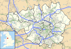
 Orrell
Orrell shown within Greater ManchesterPopulation 11,203 (2001 Census) OS grid reference SD531051 Metropolitan borough Wigan Metropolitan county Greater Manchester Region North West Country England Sovereign state United Kingdom Post town WIGAN Postcode district WN5 Dialling code 01942 01695 Police Greater Manchester Fire Greater Manchester Ambulance North West EU Parliament North West England UK Parliament Makerfield List of places: UK • England • Greater Manchester Orrell is an area of the Metropolitan Borough of Wigan, Greater Manchester, England.[1] The area is contiguous to the town of Wigan itself and the centre of the district is situated 3 miles (4.8 km) to the west of the town centre. The area today forms a predominantly residential suburb[2] along with the adjoining area of Pemberton.
Historically a part of Lancashire, Orrell was once a centre of a flourishing mining industry, though today no evidence of the area's industrial past is present. The expansion of Wigan has led to the area's suburbanisation. The electoral ward of Orrell has a population of 11,203.[3]
Contents
History
Toponymy
Orrell derives from the Anglo Saxon ora and hyll, a hill where ore is dug.[4] Its recorded name has varied over the centuries, in recent times it is known as Orrell-in-Makerfield[5] as Orrell is one of the historic Makerfield districts. Orrell is recorded as Horhill in 1202[citation needed], Horul in 1212, Orel in 1292, Orhull in 1294 and Orul in 1307.
Orrell was also the family name of a number of landowners in the area and various branches of the Orrell family held small estates here for centuries. There are records from 1558 showing William Orrell living at Orrell Hall.[5]
Industrial history
The coal measures of the Lancashire Coalfield were mined extensively at the Orrell Collieries between 1740 and 1850. A tramroad modelled on John Blenkinsop's railway at Middleton was built in 1812 from the pits to the Leeds and Liverpool Canal at Crooke. Robert Daglish was its engineer.[6] A cottage nail making industry flourished at the same time.[7] Another main employer was the Sandbrook Cotton mill where raw cotton was spun into thread and the many women who worked there came home covered in lint. No significant industry is now present in the area, as the area now serves primarily as a residential suburb for commuters.
Post War
Orrell was also where the last known case of black death occurred in 1973.[citation needed]
Divided by the M58 motorway, the area has developed two unofficial 'sections': the southern section with railway station and Orrell Rugby Union Club's former 'Edge Hall Road' ground; and Orrell Post, at the northern side of the M58. The original Orrell 'post', signifying a halt on the turnpike road, is still outside the Stag public house at a crossroads[citation needed]. The area's proximity to Wigan town centre and its position at a junction of the M6, make it an attractive location from which to commute.
Governance
From 1894 to 1974, Orrell formed its own local government district; Orrell Urban District, and lay within the administrative county of Lancashire.[8]
With the coming of local government reforms in 1974, Orrell's Urban District status was abolished and the area was amalgamated into the newly formed Metropolitan Borough of Wigan, in Greater Manchester.[9]
Orrell forms part of the Makerfield parliamentary constituency, which is represented in the House of Commons by Labour Member of Parliament, Yvonne Fovargue, replacing Ian McCartney who retired at the 2010 election.
Geography
The area's northern section surrounds junction 26 of the M6 motorway. The M6 motorway passes north-south through the area and the section of Orrell to the east of the M6 directly adjoins the district of Pemberton. Orrell and Pemberton form one contiguous residential area.
Orrell is one of twenty five electoral wards that make up the Metropolitan Borough of Wigan. Orrell is part of the Wigan Urban Area.
Education
St John Rigby College [1] is situated at the northern edge of the Orrell area. St Peter's RC High School [2], consistently top of the Wigan schools' league table[10] is located on the adjacent road to Orrell Library. Abraham Guest High [3] is located on the eastern side of the M6 Motorway.
Community facilities
Orrell Library [4] used to be located on Orrell Rd but was closed in March 2010 and relocated to the new nearby Abraham Guest High School, despite local attempts to keep the original site open.
To the south of the area is Orrell Water Park,[11] a disused water storage reservoir, which has now been turned to leisure use and attracts walkers, fishermen and picnickers.
The broadcasting studios of Wish FM, radio for the WIgan/St.Helens area, are located in the area.[12] on the eastern side of the M6.
Transport
The area's principal road is the A577 Boothstown to Ormskirk. The M6 motorway runs north-south through the area. The easily accessible East Lancashire Road and M62 gives access to Manchester. The M58 provides the Wigan area with a link to the Metropolitan Borough of Sefton and indirectly the City of Liverpool.[13] It is proposed that the Orrell area (Junction 26 of the M6) be the starting point of the A5225 Wigan and Hindley bypass road linking the M6 and the M58 with the M61 at Bolton. Orrell railway station is located at the southern section of the area providing services eastbound to Manchester (passing through Wigan Wallgate) and westbound to Kirkby (passing through Upholland railway station).
Sport
The area is the home of South Lancashire & Cheshire Division 2 side Orrell Rugby Union Football Club [5]. The senior and junior academy sides of Wigan Warriors [6] rugby league club play their home games at Edge Hall Road.[14] Orrell left Edge Hall Road at the end of the 2006–2007 season and began playing at St John Rigby College.[15]
The Orrell Otters currently ply their trade in the South Lancs Counties Second Division after winning the Third Division championship in their debut season, and are also the current Houghton Memorial Cup holders after winning the trophy in 2010.
References
- Notes
- ^ "Greater Manchester Gazetteer". Greater Manchester County Record Office. Places names - O to R. http://www.gmcro.co.uk/Guides/Gazeteer/gazzo2r.htm. Retrieved 17 June 2008.
- ^ Edge Hall Road, wiganwarriors.com. URL accessed 16 February 2007.
- ^ Figures taken from Orrell, 2001 England & Wales Census, neighbourhood.statistics.gov.uk. URLs accessed 16 February 2007.
- ^ Mills 1998, p. 262
- ^ a b Orrell, Billinge, Winstanley Township, wigan.gov.uk. URL accessed 16 February 2007.
- ^ Ashmore 1982, p. 120
- ^ Townships;Orrell, British-history.ac.uk. URL accessed 17 February 2007.
- ^ Orrell UD, Vision of Britain. URL accessed 16 February 2007.
- ^ HMSO. Local Government Act 1972. 1972 c.70.
- ^ Schools in Wigan, BBC News Online, 19 January 2006. URL accessed 16 February 2007.
- ^ Wigan's Countryside - Orrell Water Park, Wigan Leisure & Culture Trust. URL accessed 16 February 2007.
- ^ Contact Us, Wish Fm. URL accessed 16 February 2007.
- ^ M58, CBRD - Motorway Database. URL accessed 16 February 2007.
- ^ Wigan Warriors - The Official Website
- ^ Orrell to quit Edge Hall Road, Wigan Observer, 24 January 2007. URL accessed 16 February 2007.
- Bibliography
External links
- UK & Ireland Genealogy - Orrell, Genealogy and Gazzetter webspace about Orrell.
- Orrell, Billinge, Winstanley Township, Wigan MBC website.
Categories:- Geography of Wigan
- Districts of Greater Manchester

Wikimedia Foundation. 2010.