- Air New Zealand Flight 901
-
Air New Zealand Flight 901 
Most of the wreckage of Flight 901 remains on the slopes of Mount Erebus. This photo, taken on the 25th anniversary in 2004, shows part of the DC-10's upper fuselage skin with entry door and cabin windows. Part of the opposite side skin, with missing door, is still attached (top left).Accident summary Date 28 November 1979 Type Controlled flight into terrain Site Mount Erebus, Ross Island, Antarctica Passengers 237 Crew 20 Fatalities 257 (all) Survivors 0 Aircraft type McDonnell Douglas DC-10-30 Operator Air New Zealand Tail number ZK-NZP Flight origin Auckland International Airport
(now Auckland Airport)Stopover Christchurch International Airport Destination Auckland International Airport Air New Zealand Flight 901 (TE-901)[note 1] was a scheduled Air New Zealand Antarctic sightseeing flight that operated between 1977 and 1979, from Auckland Airport to Antarctica and return via Christchurch. On 28 November 1979, the fourteenth flight of TE901, a McDonnell Douglas DC-10-30 registered ZK-NZP, collided with Mount Erebus on Ross Island, Antarctica, killing all 237 passengers and 20 crew on board.[1][2] The accident is commonly known as the Mount Erebus disaster.
The initial investigation concluded the accident was caused by pilot error but public outcry led to the establishment of a Royal Commission of Inquiry into the crash. The commission, presided over by Justice Peter Mahon, concluded that the accident was caused by a correction made to the coordinates of the flight path the night before the disaster, coupled with a failure to inform the flight crew of the change, with the result that the aircraft, instead of being directed by computer down McMurdo Sound (as the crew assumed), was re-routed into the path of Mount Erebus. In Justice Mahon's report, he accused Air New Zealand of presenting "an orchestrated litany of lies" and this charge in the end led to changes in senior management at the airline. The accident remains New Zealand's deadliest peacetime disaster.[3]
Contents
Background
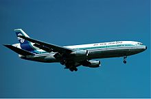 The accident aircraft, ZK-NZP seen at London Heathrow Airport in 1977
The flight was designed and marketed as a unique sightseeing experience, carrying an experienced Antarctic guide who pointed out scenic features and landmarks using the aircraft public-address system, while passengers enjoyed a low-flying sweep of McMurdo Sound.[4] The flights left and returned to New Zealand the same day.
Flight 901 would leave Auckland International Airport at 8:00am for Antarctica, and arrive back at Christchurch International Airport at 7:00pm after flying a total of 5,360 miles (8,630 km). The aircraft would make a 45-minute stop at Christchurch for refuelling and crew change, before flying the remaining 464 miles (747 km) to Auckland, arriving at 9:00pm. Tickets for the November 1979 flights cost NZ$359 per person (equal to around $1218 in September 2009).[5][6]
Dignitaries such as Sir Edmund Hillary had acted as guides on previous flights. Hillary was scheduled to act as the guide for the flight but had to cancel owing to other commitments. His long-time friend and climbing companion, Peter Mulgrew, stood in as guide.[7]
The flights usually operated at about 85% of capacity; the empty seats, usually the centre ones, allowed passengers to move more easily about the cabin to look out of the windows.
The aircraft used on the Antarctic flights were Air New Zealand's eight McDonnell Douglas DC-10-30 trijets. The aircraft on 28 November was registered ZK-NZP. The 182nd DC-10 to be built, and the fourth DC-10 to be introduced by Air New Zealand, ZK-NZP was handed over to the airline on 12 December 1974 at McDonnell Douglas's Long Beach plant. It was the first Air New Zealand DC-10 to be fitted with General Electric CF6-50C engines as built, and had logged 20,750 flight hours prior to the crash.[1][8]
Accident
- All times are as at McMurdo Base: New Zealand Standard Time; UTC+12. Mainland New Zealand was running on New Zealand Daylight Time (UTC+13) at the time of the crash.
Circumstances surrounding the accident
Captain Jim Collins and co-pilot Greg Cassin had never flown to Antarctica before, but they were experienced pilots considered qualified for the flight. On 9 November 1979, 19 days before departure, the two pilots had attended a briefing in which they were given a copy of the previous flight's flight plan.[4]
Unknown to Captain Collins at the time of the briefing, the flight plan coordinates transcribed into Air New Zealand's ground computer differed from the route flight plan approved in 1977 by the New Zealand Department of Transport Civil Aviation Division. The approved flight plan was along a track directly from Cape Hallett to the McMurdo Non-Directional Beacon (NDB), which, coincidentally, entailed flying almost directly over the 12,448 ft peak of Mt Erebus. However, the print out from Air New Zealand's ground computer system presented at the 9 November briefing corresponded to a southerly flight path down the middle of the wide McMurdo Sound, leaving Mt Erebus approximately 27 miles to the east. The majority of previous flights had also entered this flight plan's coordinates into their aircraft INS navigational systems and flown the McMurdo Sound route, unaware that the route flown did not correspond with the approved route.[9]
Captain Simpson, the pilot of a previous flight on 14 November, and also present at the 9 November briefing, compared the coordinates of the McMurdo TACAN navigation beacon (approximately three miles east of McMurdo NDB), and the McMurdo waypoint that the flight crew had entered into the INS, and was surprised to find a large distance between the two. After this flight, Captain Simpson advised Air New Zealand's Navigation section of the difference in positions. For reasons that were disputed, this triggered Air New Zealand's Navigation section to subsequently resolve to update the McMurdo waypoint coordinates stored in the ground computer to correspond with the coordinates of the McMurdo TACAN beacon, despite this also not corresponding with the approved route.
The Navigation section changed the McMurdo waypoint coordinate stored in the ground computer system at approximately 1:40 am on the morning of the flight. Crucially, the flight crew of Flight 901 was not notified of the change. The flight plan print-out given to the crew on the morning of the flight, which was subsequently hand entered by the flight crew into the aircraft's INS, differed from the flight plan presented at the 9 November briefing and to Captain Collins' map mark-ups he had prepared the night previously. The key difference between the routes was that the flight plan presented at the November 9 briefing corresponded to a track down McMurdo Sound, giving Mt Erebus a wide berth to the east, whereas the flight plan printed on the morning of the flight corresponded to a track that coincided with Mt Erebus. In contrast to the McMurdo Sound route, the updated route would result in a collision with Mt Erebus if this leg was flown at an altitude of less than 13,000 feet.[9] Additionally, the computer program was altered such that the standard telex forwarded to Air Traffic Controllers at McMurdo displayed the word "McMurdo" rather than the co-ordinates of latitude and longitude, for the final waypoint. During the subsequent inquiry Justice Mahon concluded that this was a deliberate attempt to conceal from the United States authorities that the flight plan had been changed, and probably because it was known that the United States Air Traffic Control would lodge an objection to the new flight path.[10]
The flight had earlier paused during the approach to McMurdo Sound to carry out a descent, via a figure-eight manoeuvre, through a gap in the low cloud base (later estimated to be at approximately 2,000–3,000 feet) whilst over water in order to establish visible contact with surface landmarks, and afford the passengers a better view.[11] It was established that either the flight crew was unaware of, or ignored, the approved route's Minimum Safe Altitude (MSA) of 16,000 ft for the approach to Mt Erebus, and 6,000 ft in the sector south of Mt Erebus (and then only when the cloud base was at 7,000 ft or better). Photographs and news stories from previous flights showed that many of these had also been flown at levels substantially below the route's MSA. In addition, pre-flight briefings for previous flights had authorised descents to any altitude authorised by the US Air Traffic Controller at McMurdo Station. As the US ATC expected Flight 901 to follow the same route as previous flights down McMurdo Sound, and in accordance with the route waypoints previously advised by Air New Zealand to them, the ATC advised Flight 901 that it had a radar that could let them down to 1,500 ft. The aircraft was not located by the radar equipment, and the crew experienced difficulty establishing VHF communications. The distance measuring equipment (DME) did not lock onto the McMurdo Tactical Air Navigation System (TACAN) for any useful period.[12]
Cockpit Voice Recorder (CVR) transcripts from the last minutes of the flight before impact with Mt Erebus indicated that the flight crew believed they were flying over McMurdo Sound, well to the west of Mt Erebus and with the Ross Ice Shelf visible on the horizon, when in reality they were flying directly towards the mountain. Despite most of the crew being engaged in identifying visual landmarks at the time, they never perceived the mountain directly in front of them. Approximately six minutes after completing a descent in Visual Meteorological Conditions, Flight 901 collided with the mountain at an altitude of approximately 1,500 ft. Passenger photographs taken seconds before collision removed all doubt of a "flying in cloud" theory, showing perfectly clear visibility well beneath the cloud base, with landmarks 13 miles to the left and 10 miles to the right of the aircraft visible.[13]
Changes to the coordinates and departure
The crew input the coordinates into the plane's computer before they departed at 7:21 am from Auckland International Airport (now Auckland Airport). Unknown to them, the coordinates had been modified earlier that morning to correct the error introduced years previously and undetected until then. The crew evidently did not check the destination waypoint against a topographical map (as did Captain Simpson on the flight of November 14) or they would have noticed the change. These new coordinates changed the flight plan to track 27 miles (43 km) east of their understanding. The coordinates programmed the plane to overfly Mount Erebus, a 3,794 m (12,448 ft) high volcano, instead of down McMurdo Sound.[4]
About four hours after a smooth take-off the flight was 42 miles (68 km) away from McMurdo Station. The radio communications centre there allowed the pilots to descend to 10,000 ft (3,000 m) and to continue "visually." Air safety regulations at the time did not allow flights to descend to lower than 6,000 ft (1,800 m), even in good weather, although Air New Zealand's own travel magazine showed photographs of previous flights clearly operating below 6,000 ft (1,800 m). Collins believed the plane was over open water.[4]
Collision with Mount Erebus
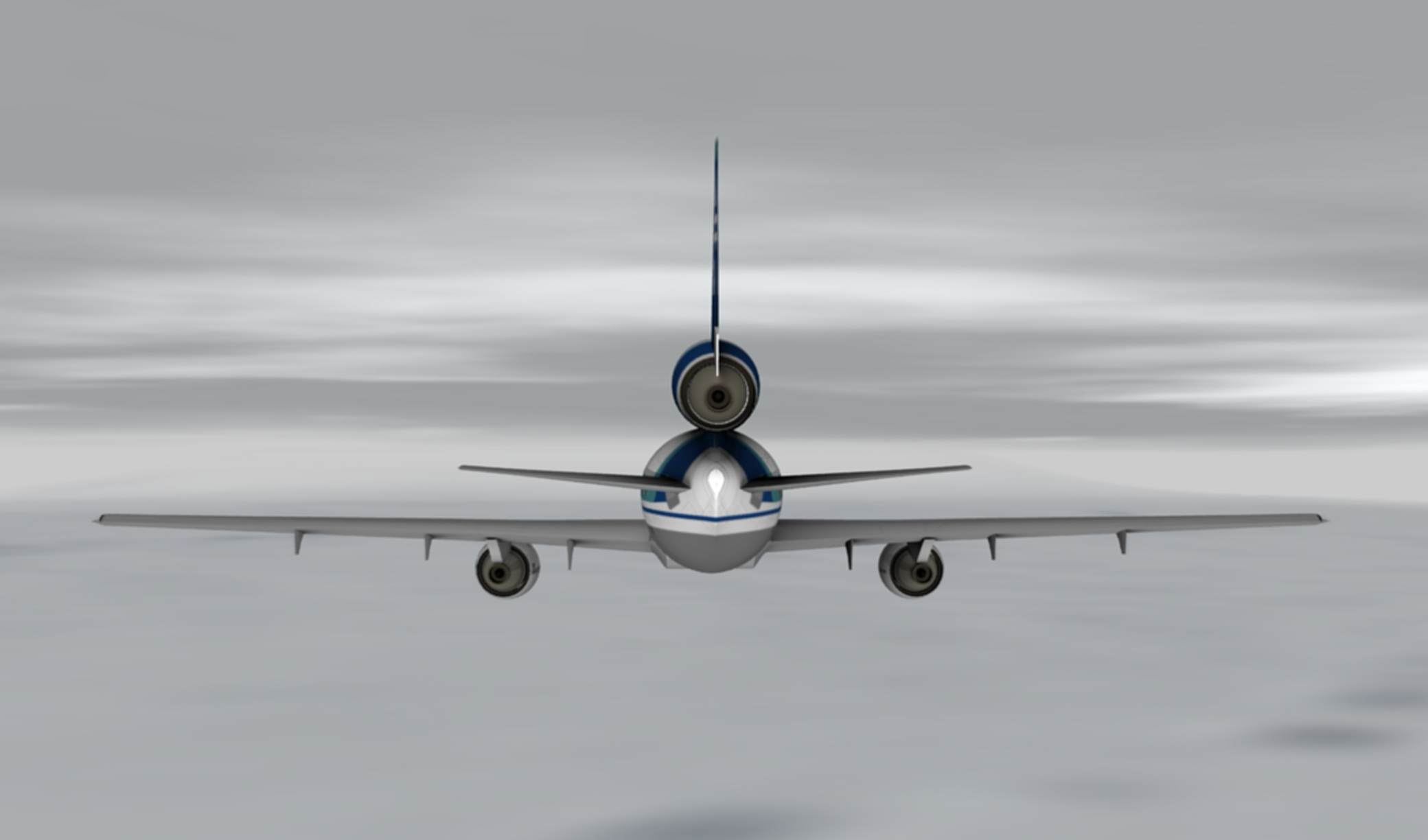
 Illustration of whiteout conditions ZK-NZP may have experienced on approach to Mt Erebus
Collins told McMurdo Station that he would be dropping to 2,000 ft (610 m), at which point he switched control of the aircraft to the automated computer system. At the time there was a layer of cloud that blended with the white of the volcano, forming a sector whiteout – there was no contrast between the two to warn the pilots. The effect was to fool all on the flight deck into thinking that the white mountainside was the Ross Ice Shelf, a huge expanse of floating ice derived from the great ice sheets of Antarctica, which was in fact now behind the mountain. As it was little understood, even by experienced polar pilots, Air New Zealand had provided no training for the flight crew on the sector whiteout phenomenon. Consequently, the crew thought they were flying along McMurdo Sound, when they were flying over Lewis Bay in front of Mt. Erebus.[4]
At 12:49pm, the ground proximity warning system (GWPS) began sounding a warning that the plane was dangerously close to terrain. Although Collins immediately requested go-around power,[14] there was no time to divert the aircraft and six seconds later the plane collided with the side of Mount Erebus and disintegrated, instantly killing all on board. The accident occurred at 12:50pm at a position of 77°25′30″S 167°27′30″E / 77.425°S 167.45833°E, and at an elevation of 1467 feet AMSL.[15] Most of the aircraft was smashed into small pieces, with the exception of the tail section.
McMurdo Station attempted to contact the flight after the crash, and informed Air New Zealand headquarters in Auckland that communication with the aircraft had been lost. United States search and rescue personnel were placed on standby.[4]
Nationalities of passengers and crew
Air New Zealand had not lost a passenger until this accident.[16]
The nationalities of the passengers and crew included[4][17]:
Country Passengers Crew  New Zealand
180 20  Japan
Japan24  United States
22  United Kingdom
6  Canada
2  Australia
1  France
1  Switzerland
1 Total 237 20 Rescue and recovery
Initial search and discovery
At 2:00pm the United States Navy released a situation report, stating:
- Air New Zealand Flight 901 has failed to acknowledge radio transmissions. ... One LC-130 fixed-wing aircraft and two UH-1N rotary wing aircraft are preparing to launch for SAR effort.[18]
Data gathered at 3:43 pm was added to the situation report, stating that the visibility was 40 miles (64 km). It also stated that six aircraft had been launched to find the flight.[19]
Flight 901 was supposed to arrive back at Christchurch at 6:05 pm, for a stopover including refuelling and a crew change before completing the journey back to Auckland. Around 50 passengers were also supposed to disembark at Christchurch. Initially airport staff told the waiting families that it was usual for the flight to be slightly late, but as time went on, it became clear that something was wrong.[20]
At 9:00 pm, about half an hour after the plane would have run out of fuel, Air New Zealand informed the press that it believed the aircraft to be lost. Rescue teams searched along the assumed flight path, but found nothing. At 12:55 am, the crew of a United States Navy aircraft discovered unidentified debris along the side of Mount Erebus.[21] No survivors could be seen. At around 9:00 am, twenty hours after the crash, helicopters with search parties managed to land on the side of the mountain. It was confirmed that the wreckage was that of Flight 901 and that all 237 passengers and 20 crewmembers had been killed. The DC-10's altitude at the time of the collision was 1,465 ft (445 m).
The vertical stabilizer section of the plane, with the koru logo clearly visible, was found in the snow.[22] Bodies and fragments of the aircraft were flown back to Auckland for identification.[23] The remains of 44 of the victims were not individually identified, and the funeral for them was held on 22 February 1980.
Operation Overdue
The recovery effort of Flight 901 was called "Operation Overdue".
Efforts for recovery were extensive, owing in part to the pressure from Japan, as 24 passengers had been Japanese. The operation lasted until 9 December 1979, with up to 60 recovery workers on site at a time. A team of New Zealand Police officers and a Mountain Face Rescue team were dispatched on a No 40 Squadron C-130 Hercules aircraft.
The job of individual identification took many weeks, and was largely done by teams of pathologists, dentists and police. The mortuary team was led by Inspector Jim Morgan, who collated and edited a report on the recovery operation. Record keeping had to be meticulous because of the number and fragmented state of the human remains that had to be identified to the satisfaction of the coroner. From a purely technical point of view the exercise was both innovative and highly successful, with 83% of the deceased eventually being identified, sometimes from evidence such as a finger capable of yielding a print, or keys in a pocket.
The fact that we all spent about a week camped in polar tents amid the wreckage and dead bodies, maintaining a 24 hour work schedule says it all. We split the men into two shifts (12 hours on and 12 off), and recovered with great effort all the human remains at the site. Many bodies were trapped under tons of fuselage and wings and much physical effort was required to dig them out and extract them.Initially, there was very little water at the site and we had only one bowl between all of us to wash our hands in before eating. The water was black. In the first days on site we did not wash plates and utensils after eating but handed them on to the next shift because we were unable to wash them. I could not eat my first meal on site because it was a meat stew. Our polar clothing became covered in black human grease (a result of burns on the bodies).
We felt relieved when the first resupply of woollen gloves arrived because ours had become saturated in human grease, however, we needed the finger movement that wool gloves afforded, i.e. writing down the details of what we saw and assigning body and grid numbers to all body parts and labelling them. All bodies and body parts were photographed in situ by U.S. Navy photographers who worked with us. Also, U.S. Navy personnel helped us to lift and pack bodies into body bags which was very exhausting work.
Later, the Skua gulls were eating the bodies in front of us, causing us much mental anguish as well as destroying the chances of identifying the corpses. We tried to shoo them away but to no avail, we then threw flares, also to no avail. Because of this we had to pick up all the bodies/parts that had been bagged and create 11 large piles of human remains around the crash site in order to bury them under snow to keep the birds off. To do this we had to scoop up the top layer of snow over the crash site and bury them, only later to uncover them when the weather cleared and the helos were able to get back on the site. It was immensely exhausting work.
After we had almost completed the mission, we were trapped by bad weather and isolated. At that point, NZPO2 and I allowed the liquor that had survived the crash to be given out and we had a party (macabre, but we had to let off steam).
We ran out of cigarettes, a catastrophe that caused all persons, civilians and Police on site, to hand in their personal supplies so we could dish them out equally and spin out the supply we had. As the weather cleared, the helos were able to get back and we then were able to hook the piles of bodies in cargo nets under the helicopters and they were taken to McMurdo. This was doubly exhausting because we also had to wind down the personnel numbers with each helo load and that left the remaining people with more work to do. It was exhausting uncovering the bodies and loading them and dangerous too as debris from the crash site was whipped up by the helo rotors. Risks were taken by all those involved in this work. The civilians from McDonnell Douglas, MOT and US Navy personnel were first to leave and then the Police and DSIR followed. I am proud of my service and those of my colleagues on Mount Erebus.[24]—Jim MorganThe last searchers off the mountain were Sergeant Mark Penn and Constable Al Windleburn and several DSIR personnel, after a final 36 hours non-stop shift.
In 1979 the post traumatic stress suffered by the body recovery and identification teams was recognised, some of whom broke down under their grim duty. Counselling was offered to all who wished it, and the debriefing report specifically noted the need for officers in command of such operations to know how to recognise and deal with the signs of stress in staff. It took several years more for psychological support to become standard practice in the New Zealand Police.
There was no official group recognition for the efforts of the police involved on this occasion, but Inspector R. S. Mitchell, leader of the body recovery team, and Inspector Morgan, leader of the DVI team, were awarded the OBE for their services in relation to this disaster.
In 2006 the New Zealand Special Service Medal (Erebus) was instituted to recognise the service of New Zealanders, and citizens of the United States of America and other countries, who were involved in the body recovery, identification and crash investigation phases of Operation Overdue. On 5 June 2009 the New Zealand government recognized some of the Americans who assisted in Operation Overdue during a ceremony in Washington, D.C. A total of 40 Americans, mostly Navy personnel, are eligible to receive the medal.[25]
Accident inquiries
Despite Flight 901 crashing in one of the most isolated parts of the world, evidence from the crash site was extensive. Both the cockpit voice recorder and the flight data recorder were still in working order and able to be deciphered. Extensive photographic footage from the moments before the crash was available - being a sightseeing flight, most passengers were carrying cameras, of which the majority of the film was able to be developed.[26][27]
Official accident report
The accident report compiled by New Zealand's chief inspector of air accidents, Ron Chippindale, was released on 12 June 1980. It cited pilot error as the principal cause of the accident and attributed blame to the decision of Collins to descend below the customary minimum altitude level, and continue at that height when the crew was unsure of the plane's position. The customary minimum altitude prohibited descent below 6,000 ft (1,830 m) even under good weather conditions, but a combination of factors led the captain to believe the plane was over the sea (the middle of McMurdo Sound and few small low islands), and previous flight 901 pilots had regularly flown low over the area to give passengers a better view, as evidenced by photographs in Air New Zealand's own travel magazine and by first-hand accounts of personnel based on the ground at NZ's Scott Base.
Mahon Inquiry
In response to public demand, the New Zealand Government announced a further one-man Royal Commission of Inquiry into the accident, to be performed by the highly respected judge Justice Peter Mahon.
Mahon's report, released on 27 April 1981, cleared the crew of blame for the disaster. Mahon said the single, dominant and effective cause of the crash was Air New Zealand's alteration of the flight plan waypoint coordinates in the ground navigation computer without advising the crew. The new flight plan took the aircraft directly over the mountain, rather than along its flank. Due to whiteout conditions, "a malevolent trick of the polar light", the crew were unable to visually identify the mountain in front of them. Furthermore, they may have experienced a rare meteorological phenomenon called sector whiteout which creates the visual illusion of a flat horizon far in the distance (it appeared to be a very broad gap between cloud layers allowing a view of the distant Ross Ice Shelf and beyond). Mahon noted that the flight crew, with many thousands of hours of flight time between them, had considerable experience with the extreme accuracy of the aircraft's inertial navigation system. Mahon also found that the radio communications centre at McMurdo Station had authorised Collins to descend to 1,500 ft (450 m), below the minimum safe level.
In para. 377 of his report, Mahon controversially claimed airline executives and senior (management) pilots engaged in a conspiracy to whitewash the inquiry, accusing them of "an orchestrated litany of lies" by covering up evidence and lying to investigators. Mahon found that in the original report Chippindale had a poor grasp of the flying involved in jet airline operation, as he (and the New Zealand CAA in general) was typically involved in investigating simple light aircraft crashes. Chippindale's investigation techniques were revealed as lacking in rigour, allowing for errors and avoidable gaps in knowledge to occur in reports. Consequently Chippindale entirely missed the importance of the flight plan change and the rare meteorological conditions of Antarctica. Had the pilots been informed of the flight plan change, the crash would have been avoided.
Appeals
Air New Zealand appealed against Mahon's findings to the Court of Appeal, which set aside the costs order against the airline. Mahon in turn appealed to the Privy Council in London. His findings as to the cause of the accident, namely reprogramming of the aircraft's flight plan by the ground crew who then failed to inform the flight crew, had not been challenged before the Court of Appeal, and so were not challenged before the Privy Council. His conclusion that the crash was the result of the aircrew being misdirected as to their flight path, not due to pilot error, therefore remained. But the Board held that Mahon had acted in excess of his jurisdiction and in breach of natural justice by going on to make findings of a conspiracy by Air New Zealand to cover up the errors of the ground staff. In their judgement, delivered on 20 October 1982, the Law Lords dismissed Mahon's appeal and upheld the decision of the Court of Appeal. Aviation researcher John King wrote in his book New Zealand Tragedies, Aviation:
- They demolished his case (Mahon's case for a cover-up) item by item, including Exhibit 164 which they said could not "be understood by any experienced pilot to be intended for the purposes of navigation" and went even further, saying there was no clear proof on which to base a finding that a plan of deception, led by the company's chief executive, had ever existed.
"Exhibit 164" was a photocopied diagram of McMurdo Sound showing a southbound flight path passing west of Ross Island and a northbound path passing the island on the east. The diagram did not extend sufficiently far south to show where, how, or even if they joined, and left the two paths disconnected. Evidence had been given to the effect that the diagram had been included in the flight crew's briefing documentation.
Justice Mahon's report was finally tabled in Parliament by the then Minister of Transport, Maurice Williamson, in 1999.
Legacy of the disaster
The crash of Flight 901 is one of New Zealand's two deadliest disasters - the other being the 1931 Hawke's Bay earthquake, which killed 256 people. At the time of the disaster, it was the fourth-deadliest air crash of all time, and as of 2010[update] ranks sixteenth.
Flight 901, in conjunction with the crash of American Airlines Flight 191 earlier that year, severely hurt the reputation of the McDonnell Douglas DC-10. ZK-NZP, along with the other seven Air New Zealand DC-10s, had only just returned to service after being grounded following the crash of Flight 191 when the crash of Flight 901 occurred. Flight 901 was the third deadliest accident involving a DC-10, following Turkish Airways Flight 981 and American Airlines Flight 191.
The crash spelled the end of commercially operated Antarctic sightseeing flights - Air New Zealand cancelled all its Antarctic flights after Flight 901, and Qantas suspended its Antarctic flights in February 1980, only returning on a limited basis again in 1994 (see Tourism in Antarctica).
The crash marked the beginning of the end for Air New Zealand's DC-10 Fleet, although there has been talk before the accident of replacing the aircraft. The DC-10s were replaced by Boeing 747 aircraft from mid 1981, and the last Air New Zealand DC-10 flew in December 1982.
Almost all of the aircraft's wreckage still lies where it came to rest on the slopes of Mount Erebus, under a layer of snow and ice. During warm periods, when snow recedes, it is still visible from the air.
A television miniseries, Erebus: The Aftermath, focusing on the investigation and the Royal Commission of Inquiry, was broadcast in New Zealand and Australia in 1988.
The phrase "an orchestrated litany of lies" entered New Zealand popular culture for some years.[28][29][30]
In the New Zealand Queen's Birthday Honours list in June 2007 Captain Gordon Vette was awarded the ONZM (Officer of the New Zealand Order of Merit), recognising his services in assisting Justice Mahon during the Erebus Inquiry. Vette's book, Impact Erebus, provides a commentary of the flight, its crash and the subsequent investigations.
In 2008, Justice Mahon was posthumously awarded the Jim Collins Memorial Award by the New Zealand Airline Pilots Association for exceptional contributions to air safety, "in forever changing the general approach used in transport accidents investigations world wide." [31]
In 2009, Air New Zealand's CEO Rob Fyfe apologised to all those affected who did not receive appropriate support and compassion from the company following the incident, and unveiled a commemorative sculpture at its headquarters.[32][33]
The registration of the crashed aircraft, ZK-NZP, has not been reissued.
Memorials
A wooden cross was erected on the mountain above Scott Base to commemorate the accident. It was replaced in 1986 with an aluminium cross after the original was eroded by low temperatures, wind and moisture.
The memorial for the 16 passengers who were unidentifiable and the 28 whose bodies were never found is at Waikumete Cemetery in Glen Eden, Auckland. Beside the memorial is a Japanese cherry tree, planted as a memorial to the 24 Japanese passengers who died.[34]
A memorial to the crew members of Flight 901 is located adjacent to Auckland Airport, on Tom Pearce Drive at the eastern end of the airport zone.[35]
In January 2010, a 26 kg sculpted koru containing letters written by the loved ones of those who died was placed next to the Antarctic cross.[36] It was originally to have been placed at the site by six relatives of the victims on the 30th anniversary of the crash, 28 November 2009, but this was delayed for two months due to bad weather. It is planned for a second koru capsule, mirroring the first capsule, to be placed at the cross in 2011.[37]
See also
- Accidents and incidents in aviation
- Ansett New Zealand Flight 703
- EGPWS
- List of New Zealand disasters by death toll
- New Zealand National Airways Corporation Flight 441
- Sensory illusions in aviation
- Tourism in Antarctica
- Similar aircraft incidents
- American Airlines Flight 965, a flight which crashed into terrain after pilots altered the coordinates.
- Aviateca Flight 901, a flight of the same number which also collided with a volcano.
Notes
- ^ At the time of the crash, Air New Zealand's IATA code was TE, a relic from its predecessor Tasman Empire Airways Limited (TEAL). The airlines's IATA code would later change to the present NZ.
References
- ^ a b Accident description for ZK-NZP at the Aviation Safety Network. Retrieved on 24 August 2011.
- ^ "DC-10 playbacks awaited" (pdf). Flight International: 1987. 15 December 1979. http://www.flightglobal.com/pdfarchive/view/1979/1979%20-%204557.html. Retrieved 24 August 2011. "At press time no information had been released concerning the flightdata and cockpit-voice recorder of Air New Zealand McDonnell Douglas DC-10 ZK-NZP which crashed on Mount Erebus on November 28."
- ^ Air NZ apologises for Mt Erebus crash The Age Retrieved 14 January 2011
- ^ a b c d e f g Christchurch City Libraries. "New Zealand Disasters: Aircraft Accident: DC. 10 ZK-NZP Flight 901". http://library.christchurch.org.nz/kids/nzdisasters/erebus.asp. Retrieved 11 July 2006.
- ^ "The Erebus Story - The loss of TE901: Visitors to Antarctica – There and Back in a Day". http://www.erebus.co.nz/Background/AntarcticExperience/AntarcticExperiencePage2.aspx. Retrieved 2009-12-01.
- ^ "RBNZ - New Zealand Inflation Calculator". http://www.rbnz.govt.nz/statistics/0135595.html.
- ^ "Erebus disaster". NZ History. 9 June 2009. http://www.nzhistory.net.nz/culture/erebus-disaster.
- ^ Hickson, Ken (1980). Flight 901 to Erebus. Whitcoulls Publishers. ISBN 978-0-7233-0641-2.
- ^ a b Mahon, Peter (1984). Verdict on Erebus. Collins. ISBN 0-00-636976-6.
- ^ Royal Commission Report, para 255(e)
- ^ "Erebus crash site map - NZhistory.net.nz". http://www.nzhistory.net.nz/media/photo/erebus-flight-path-map. Retrieved 2009-12-02.
- ^ Chippendale report, para 1.1.5
- ^ Royal Commission Report, para 28
- ^ CVR transcript from aviation-safety.net retrieved 06/02/2008
- ^ Transport Accident Investigation Commission (1980). "AIRCRAFT ACCIDENT REPORT No. 79-139: Air New Zealand McDonnell-Douglas DC10-30 ZK-NZP, Ross Island, Antarctica, 28 November 1979". Wellington, New Zealand: Office of Air Accidents Investigation, Ministry of Transport. http://www.nzalpa.org.nz/Portals/4/Documents/Reports/Chippindale/79-139_section1.pdf. Retrieved 2011-05-14.
- ^ Robertson, David. Air NZ likely to switch to 747s. The Sydney Morning Herald: 30 November 1979, p.2.
- ^ "Erebus Roll of Remembrance". http://www.erebus.co.nz/MemorialandAwards/RollofRemembrance.aspx. Retrieved 2009-11-05.
- ^ Archives New Zealand. "US Navy SITREP [SITuation REPort] from 28 November 1979 (page 1)". http://www.archives.govt.nz/exhibitions/currentexhibitions/chch/pc-erebus-sitrep-1.php. Retrieved 11 July 2006.
- ^ Archives New Zealand. "US Navy SITREP [SITuation REPort] from 28 November 1979 (page 2)". http://www.archives.govt.nz/exhibitions/currentexhibitions/chch/pc-erebus-sitrep-2.php. Retrieved 11 July 2006.
- ^ "Erebus flight overdue = NZHistory.net.nz". http://www.nzhistory.net.nz/media/photo/erebus-flight-overdue. Retrieved 2009-12-01.
- ^ Archives New Zealand. "U.S. Navy SITREP [SITuation REPort] from 28 November 1979 (page 4)". http://www.archives.govt.nz/exhibitions/currentexhibitions/chch/pc-erebus-sitrep-4.php. Retrieved 11 July 2006.
- ^ Tail of Air New Zealand plane at Mt Erebus
- ^ Bill Spindler. "Air New Zealand DC-10 crash into Mt. Erebus". http://www.southpolestation.com/trivia/history/te901.html. Retrieved 11 July 2006.
- ^ NZPO1 NZAVA–see Bibliography.
- ^ "Erebus Medals". The Antarctic Sun. http://antarcticsun.usap.gov/features/contenthandler.cfm?id=1826.
- ^ "Captain Vette's Research". http://www.erebus.co.nz/Investigation/CaptainVettesResearch.aspx. Retrieved 2009-12-01.
- ^ "A dark passage in NZ history - tvnz.co.nz". 2009-10-23. http://tvnz.co.nz/erebus-news/dark-passage-in-nz-history-3091169. Retrieved 2009-12-02.
- ^ "Banshee Reel". Archived from the original on 2009-10-24. http://www.webcitation.org/5kmDi2Fec. Retrieved 2007-11-19. "a famous quote from NZs recent political past"
- ^ "BREAKING NEWS - FEBRUARY 2004". Citizens for Health Choices. February 2004. http://www.choices.org.nz/. Retrieved 2007-11-19. "To quote a well-known phrase, there has been 'An orchestrated litany of lies'"
- ^ "Background Comments on the Stent Report" (DOC). PSA. April 1998. Archived from the original on 2007-10-07. http://web.archive.org/web/20071007062119/http://www.psa.org.nz/library/psa/general/psa+-+background+comments+on+the+stent+report+1998.doc. Retrieved 2007-11-19. "...a phrase that is likely to resound as did 'an orchestrated litany of lies' in another investigation"
- ^ "Mahon posthumously awarded". stuff.co.nz. 1 December 2008. Archived from the original on 2009-05-12. http://www.webcitation.org/5ghgE1Hpb. Retrieved 2009-05-12.
- ^ Address from Rob Fyfe, Air New Zealand CEO, at Unveiling of Momentum Sculpture, Air New Zealand press release, 23 October 2009.
- ^ Fox, Michael (23 October 2009). "Air New Zealand apology 30 years after Erebus tragedy". Stuff.co.nz. http://www.stuff.co.nz/national/2993852/Air-New-Zealand-apology-30-years-after-Erebus-tragedy. Retrieved 15 November 2009.
- ^ "Waikumete Cemetery Public Memorial". http://www.erebus.co.nz/MemorialandAwards/Memorials/WaikumeteCemeteryMemorial.aspx. Retrieved 2009-12-01.
- ^ "Crew Memorial at Auckland Airport". http://www.erebus.co.nz/MemorialandAwards/Memorials/AucklandAirportCrewMemorial.aspx. Retrieved 2009-12-01.
- ^ "Memorial placed at Mt Erebus crash site". Television New Zealand. 21 January 2010. http://tvnz.co.nz/national-news/memorial-placed-mt-erebus-crash-site-3337030/video. Retrieved 16 September 2011.
- ^ "Ballot drawn for Remembrance flight to Antarctica". Air New Zealand. 2010-09-30. http://www.airnewzealand.co.nz/press-release-2010-ballot-drawn-for-remembrance-flight-to-antarctica. Retrieved 2010-11-21.
Further reading
- NZAVA Operation Deep Freeze - The New Zealand Story, 2002.
- Operation Overdue–NZAVA Archives 2002.
- C.H.N. L'Estrange, The Erebus enquiry: a tragic miscarriage of justice, Auckland, Air Safety League of New Zealand, 1995
- Stuart Macfarlane, The Erebus papers: edited extracts from the Erebus proceedings with commentary, Auckland, Avon Press, 1991
- Report of the Royal Commission to Inquire into the Crash on Mount Erebus, Antarctica of a DC10 Aircraft Operated by Air New Zealand Limited (66 Mb file), Wellington, Government Printer, 1981 (located at Archives New Zealand; item number ABVX 7333 W4772/5025/3/79-139 part 3)
- R Chippendale, Air New Zealand McDonnell-Douglas DC10-30 ZK-NZP, Ross Island, Antarctica 28 November 1979, Office of Air Accidents Investigation, New Zealand Ministry of Transport, Wellington, 1980 (only some parts there)
- Air New Zealand History Page, including a section about Erebus
External links
- The Erebus Story - Loss of TE901 (includes Newspaper Articles and Video footage) - New Zealand Air Line Pilots' Association
- Aviation Safety Network: Transcript of flight 901
- The original brochure advertising Air New Zealand flights to Antarctica
- Judgments of the Court of Appeal of New Zealand on Proceedings to Review Aspects of the Report of the Royal Commission of Inquiry into the Mount Erebus Aircraft Disaster at Project Gutenberg
- (audio file) ABC Radio National program "Ockham's Razor": "Arthur Marcell takes us through some of the events leading up to the crash and has a few questions for modern navigators." transcript
- NZ Special Service Medal (Erebus) 2006
- Erebus disaster (NZHistory.net.nz)–includes previously unpublished images and sound files
- Erebus Aircraft Accident–Christchurch City Libraries
- Erebus for Kids–This site is for young school children to provide information about the Erebus Tragedy.
- Erebus Disaster: Lookout - official TV New Zealand YouTube site with programme on the Royal Commission enquiry into the crash.
Coordinates: 77°25′30″S 167°27′30″E / 77.425°S 167.45833°E
Jun 17 Air New England Flight 248
Jun 20 American Airlines Flight 293 hijacking
Jul 11 Garuda Fokker F28 crash
Jul 31 Dan-Air Flight 0034
Aug 11 Dniprodzerzhynsk mid-air collisionOct 31 Western Airlines Flight 2605
Nov 15 American Airlines Flight 444
Nov 26 PIA Flight 740
Nov 28 Air New Zealand Flight 901
Dec 23 Turkish Airlines Ankara crashIncidents resulting in at least 50 deaths shown in italics. Deadliest incident shown in bold smallcaps.Categories:- 1979 in Antarctica
- 1979 in New Zealand
- Accidents and incidents involving controlled flight into terrain
- Accidents and incidents involving the McDonnell Douglas DC-10
- Air New Zealand
- Aviation accidents and incidents in 1979
- Aviation accidents and incidents in Antarctica
- Aviation accidents and incidents in New Zealand
- Death in Antarctica
- Ross Island


Wikimedia Foundation. 2010.