- McPherson County, Kansas
-
McPherson County, Kansas 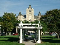 McPherson County Courthouse in McPherson
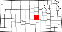
Location in the state of Kansas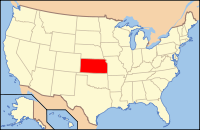
Kansas's location in the U.S.Founded February 26, 1867 Seat McPherson Area
- Total
- Land
- Water
901.24 sq mi (2,334 km²)
899.71 sq mi (2,330 km²)
1.52 sq mi (4 km²), 0.17%Population
- (2010)
- Density
29,180
32.8/sq mi (12.7/km²)Time zone Central: UTC-6/-5 Website McPhersonCountyKS.us McPherson County (standard abbreviation: MP) is a county located in the U.S. state of Kansas. As of the 2010 census, the county population was 29,180.[1] The largest city and county seat is McPherson. The county is named for Civil War General James B. McPherson. The McPherson Micropolitan Statistical Area includes all of McPherson County.
Contents
History
19th century
As early as 1875, city leaders of Marion held a meeting to consider a branch railroad from Florence. In 1878, Atchison, Topeka and Santa Fe Railway and parties from Marion County and McPherson County chartered the Marion and McPherson Railway Company.[2] In 1879, a branch line was built from Florence to McPherson, in 1880 it was extended to Lyons, in 1881 it was extended to Ellinwood.[3] The line was leased and operated by the Atchison, Topeka and Santa Fe Railway. The line from Florence to Marion, was abandoned in 1968.[4] In 1992, the line from Marion to McPherson was sold to Central Kansas Railway. In 1993, after heavy flood damage, the line from Marion to McPherson was abandoned. The original branch line connected Florence, Marion, Canada, Hillsboro, Lehigh, Canton, Galva, McPherson, Conway, Windom, Little River, Mitchell, Lyons, Chase, Ellinwood.
In 1887, the Chicago, Kansas and Nebraska Railway extended its main line from Herington to Pratt.[5] This main line connected Herington, Ramona, Tampa, Durham, Waldeck, Canton, Galva, McPherson, Groveland, Inman, Medora, Hutchinson, Whiteside, Partridge, Arlington, Langdon, Turon, Preston, Natrona, Pratt. In 1888, this main line was extended to Liberal. Later, this line was extended to Tucumcari, New Mexico and El Paso, Texas. This line is called the "Golden State Limited".
20th century
The National Old Trails Road, also known as the Ocean-to-Ocean Highway, was established in 1912, and was routed through Windom, Conway, McPherson.
Law and government
Following amendment to the Kansas Constitution in 1986, the county remained a prohibition, or "dry", county until 1996, when voters approved the sale of alcoholic liquor by the individual drink with a 30% food sales requirement.[6]
Geography
According to the 2000 census, the county has a total area of 901.24 square miles (2,334.2 km2), of which 899.71 square miles (2,330.2 km2) (or 99.83%) is land and 1.52 square miles (3.9 km2) (or 0.17%) is water.[7]
Adjacent counties
- Saline County (north)
- Dickinson County (northeast)
- Marion County (east)
- Harvey County (southeast)
- Reno County (southwest)
- Rice County (west)
- Ellsworth County (northwest)
Demographics
Historical populations Census Pop. %± 1900 21,421 — 1910 21,521 0.5% 1920 21,845 1.5% 1930 23,588 8.0% 1940 24,152 2.4% 1950 23,670 −2.0% 1960 24,285 2.6% 1970 24,778 2.0% 1980 26,855 8.4% 1990 27,268 1.5% 2000 29,554 8.4% 2010 29,180 −1.3% U.S. Decennial Census  Age pyramid
 2005 KDOT Map of McPherson County (map legend)
As of the census[8] of 2000, there were 29,554 people, 11,205 households, and 7,966 families residing in the county. The population density was 33 people per square mile (13/km²). There were 11,830 housing units at an average density of 13 per square mile (5/km²). The racial makeup of the county was 96.53% White, 0.81% Black or African American, 0.34% Native American, 0.32% Asian, 0.06% Pacific Islander, 0.79% from other races, and 1.16% from two or more races. 1.94% of the population were Hispanic or Latino of any race. 37.1% were of German, 12.9% Swedish, 12.1% American, 6.7% English and 6.3% Irish ancestry according to Census 2000.
There were 11,205 households out of which 33.00% had children under the age of 18 living with them, 62.50% were married couples living together, 6.00% had a female householder with no husband present, and 28.90% were non-families. 25.50% of all households were made up of individuals and 11.80% had someone living alone who was 65 years of age or older. The average household size was 2.49 and the average family size was 2.99.
In the county the population was spread out with 25.40% under the age of 18, 10.30% from 18 to 24, 25.20% from 25 to 44, 21.80% from 45 to 64, and 17.30% who were 65 years of age or older. The median age was 38 years. For every 100 females there were 95.90 males. For every 100 females age 18 and over, there were 92.90 males.
The median income for a household in the county was $41,138, and the median income for a family was $48,243. Males had a median income of $33,530 versus $21,175 for females. The per capita income for the county was $18,921. About 4.20% of families and 6.60% of the population were below the poverty line, including 5.20% of those under age 18 and 8.10% of those age 65 or over.
Cities and towns
Incorporated cities
Name and population (2010):
- McPherson, 13,155
- Lindsborg, 3,458
- Moundridge, 1,737
- Inman, 1,377
- Galva, 870
- Canton, 748
- Marquette, 641
- Windom, 130
Unincorporated communities
Ghost towns
- Battle Hill
- Christian
- Doles Park
- Elivon
- King City
Townships
McPherson County is divided into twenty-five townships. The cities of Lindsborg and McPherson are considered governmentally independent and are excluded from the census figures for the townships. In the following table, the population center is the largest city (or cities) included in that township's population total, if it is of a significant size.
Sources: 2000 U.S. Gazetteer from the U.S. Census Bureau. Township FIPS Population
centerPopulation Population
density
/km² (/sq mi)Land area
km² (sq mi)Water area
km² (sq mi)Water % Geographic coordinates Battle Hill 04550 91 1 (3) 93 (36) 0 (0) 0.33% 38°29′2″N 97°25′22″W / 38.48389°N 97.42278°W Bonaville 07925 66 1 (2) 93 (36) 0 (0) 0.34% 38°32′57″N 97°30′34″W / 38.54917°N 97.50944°W Canton 10500 1,090 12 (30) 93 (36) 0 (0) 0.02% 38°23′21″N 97°25′36″W / 38.38917°N 97.42667°W Castle 10950 225 2 (6) 93 (36) 0 (0) 0.12% 38°23′9″N 97°52′44″W / 38.38583°N 97.87889°W Delmore 17575 138 1 (4) 93 (36) 0 (0) 0.15% 38°28′43″N 97°33′17″W / 38.47861°N 97.55472°W Empire 21200 1,178 13 (33) 94 (36) 0 (0) 0 % 38°23′12″N 97°32′7″W / 38.38667°N 97.53528°W Groveland 29150 234 2 (6) 94 (36) 0 (0) 0.12% 38°17′55″N 97°44′37″W / 38.29861°N 97.74361°W Gypsum Creek 29325 215 2 (6) 93 (36) 0 (0) 0.11% 38°33′32″N 97°26′12″W / 38.55889°N 97.43667°W Harper 30225 137 1 (4) 93 (36) 0 (0) 0.17% 38°28′55″N 97°45′50″W / 38.48194°N 97.76389°W Hayes 30950 287 3 (8) 94 (36) 0 (0) 0 % 38°17′55″N 97°52′54″W / 38.29861°N 97.88167°W Jackson 34850 198 2 (6) 93 (36) 0 (0) 0.49% 38°22′33″N 97°46′48″W / 38.37583°N 97.78°W King City 36900 544 6 (15) 93 (36) 0 (0) 0.13% 38°18′51″N 97°39′8″W / 38.31417°N 97.65222°W Little Valley 41600 475 5 (13) 93 (36) 0 (0) 0.02% 38°13′38″N 97°52′32″W / 38.22722°N 97.87556°W Lone Tree 42525 486 5 (13) 94 (36) 0 (0) 0 % 38°17′37″N 97°32′48″W / 38.29361°N 97.54667°W McPherson 43975 618 8 (21) 77 (30) 0 (0) 0.23% 38°23′24″N 97°38′57″W / 38.39°N 97.64917°W Marquette 44950 776 8 (22) 93 (36) 0 (0) 0.16% 38°33′9″N 97°51′30″W / 38.5525°N 97.85833°W Meridian 45975 341 4 (9) 94 (36) 0 (0) 0 % 38°12′43″N 97°26′8″W / 38.21194°N 97.43556°W Mound 48675 2,104 23 (59) 93 (36) 0 (0) 0.17% 38°12′24″N 97°31′22″W / 38.20667°N 97.52278°W New Gottland 50350 354 4 (10) 93 (36) 0 (0) 0.38% 38°28′29″N 97°38′21″W / 38.47472°N 97.63917°W Smoky Hill 66025 297 3 (9) 89 (34) 0 (0) 0.05% 38°34′35″N 97°38′59″W / 38.57639°N 97.64972°W South Sharps Creek 67000 112 1 (3) 93 (36) 0 (0) 0.18% 38°28′21″N 97°52′11″W / 38.4725°N 97.86972°W Spring Valley 67750 373 4 (10) 94 (36) 0 (0) 0.03% 38°18′2″N 97°25′21″W / 38.30056°N 97.4225°W Superior 69475 1,640 18 (46) 92 (36) 1 (0) 0.72% 38°13′28″N 97°46′1″W / 38.22444°N 97.76694°W Turkey Creek 71700 294 3 (8) 93 (36) 0 (0) 0 % 38°13′10″N 97°38′23″W / 38.21944°N 97.63972°W Union 72225 190 2 (5) 93 (36) 0 (0) 0.20% 38°33′12″N 97°44′59″W / 38.55333°N 97.74972°W Education
 Windom, Kansas in McPherson County during the early 20th century
Unified school districts
- USD 400, Smoky Valley
- USD 418, McPherson
- McPherson, Rural Areas
- USD 419, Canton-Galva
- USD 423, Moundridge
- Moundridge, Rural Areas
- USD 448, Inman
- Inman, Rural Areas
- District Office In Neighboring County
- USD 411, Goessel
- Rural Areas
- USD 444, Little River-Windom
- Windom, Rural Areas
Colleges
- McPherson College, in McPherson
- Bethany College, in Lindsborg.
- Central Christian College, in McPherson
Museums
- Birger Sandzén Memorial Gallery, in Lindsborg
- McCormick-Deering Days Museum, in Inman
- McPherson Museum, in McPherson
- McPherson County Old Mill Museum, in Lindsborg
See also
Information on this and other counties in Kansas
- List of counties in Kansas
- National Register of Historic Places listings in Kansas
- Kansas locations by per capita income
Other information for Kansas
- List of cities in Kansas
- List of unified school districts in Kansas
- List of colleges and universities in Kansas
References
- ^ "2010 County Population and Housing Occupancy Status". U.S. Census Bureau. http://factfinder2.census.gov/faces/tableservices/jsf/pages/productview.xhtml?pid=DEC_10_PL_GCTPL2.ST05&prodType=table. Retrieved March 31, 2011.
- ^ Marion County Kansas : Past and Present; Sondra Van Meter; MB Publishing House; LCCN 72-92041; 344 pages; 1972.
- ^ Fourth Annual Report of the Board of Railroad Commissioners for the Year Ending December 1, 1886 in State of Kansas; Kansas Publishing House; 1886.
- ^ Railway Abandonment 1968
- ^ Rock Island Rail History
- ^ "Map of Wet and Dry Counties". Alcoholic Beverage Control, Kansas Department of Revenue. November 2006. http://www.ksrevenue.org/abcwetdrymap.htm. Retrieved 2007-12-26.
- ^ "Census 2000 U.S. Gazetteer Files: Counties". United States Census. http://www.census.gov/tiger/tms/gazetteer/county2k.txt. Retrieved 2011-02-13.
- ^ "American FactFinder". United States Census Bureau. http://factfinder.census.gov. Retrieved 2008-01-31.
Further reading
- Kansas
- History of the State of Kansas; William G. Cutler; A.T. Andreas Publisher; 1883. (Online HTML eBook)
- Kansas : A Cyclopedia of State History, Embracing Events, Institutions, Industries, Counties, Cities, Towns, Prominent Persons, Etc; 3 Volumes; Frank W. Blackmar; Standard Publishing Co; 944 / 955 / 824 pages; 1912. (Volume1 - Download 54MB PDF eBook), (Volume2 - Download 53MB PDF eBook), (Volume3 - Download 33MB PDF eBook)
- USA
- The Story of the Marking of the Santa Fe Trail by the Daughters of the American Revolution in Kansas and the State of Kansas; Almira Cordry; Crane Co; 164 pages; 1915. (Download 4MB PDF eBook)
- The National Old Trails Road To Southern California, Part 1 (LA to KC); Automobile Club Of Southern California; 64 pages; 1916. (Download 6.8MB PDF eBook)
External links
- County
- McPherson County - Official Website
- McPherson County - Directory of Public Officials
- McPherson County - Information
- Maps
- McPherson County Map, KDOT
- Kansas Highway Map, KDOT
- Kansas Railroad Map, KDOT
- Kansas School District Boundary Map, KSDE

Ellsworth County Saline County Dickinson County Rice County 
Marion County  McPherson County, Kansas

Reno County Harvey County Municipalities and communities of McPherson County, Kansas Cities 
Unincorporated
communitiesGhost towns Christian | Elivon
Footnotes ‡This populated place also has portions in an adjacent county or counties
Categories:- Kansas counties
- McPherson County, Kansas
- 1867 establishments


Wikimedia Foundation. 2010.