- Whitley County, Kentucky
-
Whitley County, Kentucky 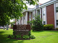 Whitley County courthouse in Williamsburg, Kentucky
Seal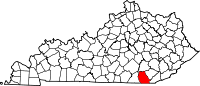
Location in the state of Kentucky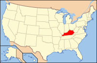
Kentucky's location in the U.S.Founded January 17, 1818 Seat Williamsburg Area
- Total
- Land
- Water
445.15 sq mi (1,153 km²)
440.15 sq mi (1,140 km²)
4.99 sq mi (13 km²), 1.12%Population
- (2000)
- Density
35,865
82/sq mi (32/km²)Time zone Eastern: UTC-5/-4 Website www.whitleycountyfiscalcourt.com Whitley County is a county located in the state of Kentucky. 2005 census projections list its population at 38,029 [1]. The county seat is at Williamsburg[1], though the largest city is Corbin, and the county's District Court (a trial court of limited jurisdiction) sits in both cities. Whitley County is a limited dry county, meaning that sale of alcohol in the county is prohibited except in certain areas as voted on by the residents of the area. In the case of Whitley County, by the drink alcohol sales is permitted only in restaurants in the city of Corbin seating at least 100 diners and derive at least 70% of their total sales from food.
The Corbin, KY Micropolitan Statistical Area includes all of Whitley County, but does not include all of the city of Corbin.
Contents
History
Whitley County was created on January 17, 1818 from adjacent Knox County, Kentucky [2]. In the years prior to its establishment as an independent county, many skirmishes were fought between native Indians and hunters and trappers in the area. The namesake of the county, Colonel William Whitley, is famous locally for fighting many of these battles within the area, eventually driving them out of southeastern Kentucky and safeguarding the Wilderness Road, as well as for his service in the War of 1812, where he died at the Battle of the Thames. The county seat was situated in Williamsburg (also named for Colonel Whitley, in 1882) from the beginning, with the first court held at the home of the town's first resident, Samuel Cox [3].
Its rugged terrain, densely forested woodlands, and a history of conflict with local Indian tribes all combined to make for a very slow rate of growth in Whitley County. The development of the coal mining industry in the area towards the late 1800s spurred on population growth as poor families from neighboring states rushed in to the county and led to the formation of Corbin, still the largest city in Whitley County.
North Corbin, just north of Whitley County is home to Sanders Cafe, which is the birthplace of Kentucky Fried Chicken. It was founded there by Harland David Sanders, better known as Colonel Sanders, in 1930.
Law and Government
The current elected officials of Whitley County are:[4]:
- County Judge/Executive: Pat White, Jr.
- County Magistrate: Roger Wells
- County Magistrate: David Myers
- County Magistrate: Jamie Fuson
- County Magistrate: Mike Baird
- County Attorney: Paul Winchester
- County Coroner: Andy Croley
- County Treasurer: Jeffrey Gray
- Sheriff: Colan Harrell
- County Surveyor: Robert Moses
- Property Valuation Administrator: Ronnie Moses
- County Clerk: Kay Schwartz
- Circuit Court Clerk: Gary Barton
Geography
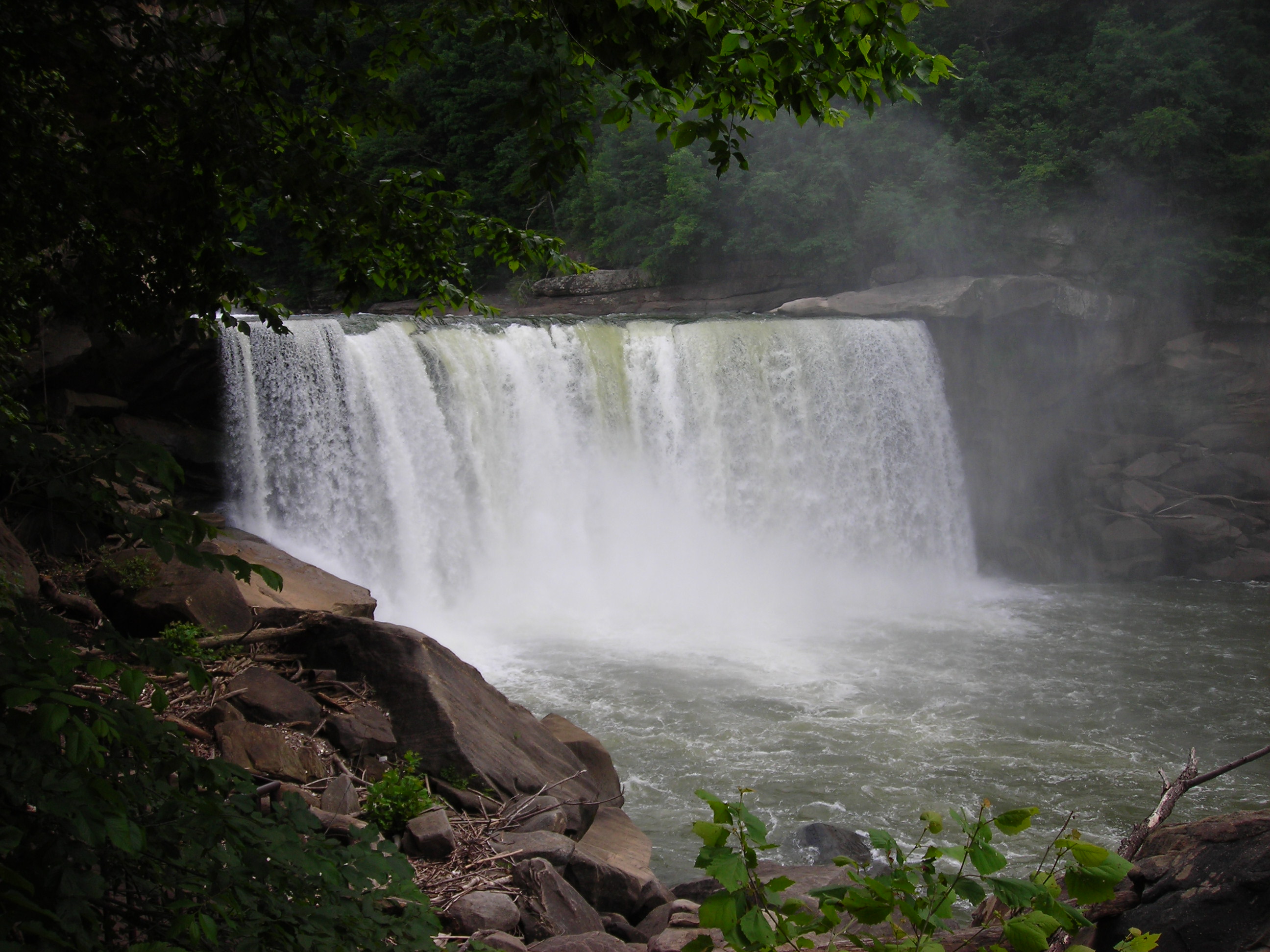
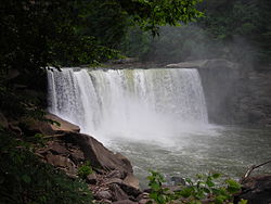 Cumberland Falls
According to the 2000 census, the county has a total area of 445.15 square miles (1,152.9 km2), of which 440.15 square miles (1,140.0 km2) (or 98.88%) is land and 4.99 square miles (12.9 km2) (or 1.12%) is water.[2]
Whitley County is located within the Cumberland Plateau of southeastern Kentucky, which is greatly overlapped by the broad Eastern Coal Field region of the state. Because of its location in the midst of Cumberland Mountains, elevations in the county range from 723 feet (220 m) to 2,220 feet (680 m) above sea level [5]. 38,000 acres (150 km2) of western Whitley County are preserved within the Daniel Boone National Forest. Cumberland Falls, located in Cumberland Falls State Resort Park, is the site of the largest waterfall in the Commonwealth of Kentucky. Both Daniel Boone Forest and Cumberland Falls State Park are operated by the Kentucky State Parks system, also located in the county. Two regionally significant waterways meander through the county, namely the Laurel and Cumberland river.
Geographic features
- Cumberland Falls
- Cumberland Plateau
- Cumberland River
- Jellico Mountain
- Laurel River
- Laurel River Lake
Major highways
- U.S. Route 25W
- State highways
- Kentucky Route 11
- Kentucky Route 26
- Kentucky Route 90
- Kentucky Route 92
- Kentucky Route 312
- Kentucky Route 904
Adjacent counties
- Laurel County - north
- Knox County - northeast
- Bell County - east
- Claiborne County, Tennessee - southeast
- Campbell County, Tennessee - south
- McCreary County - west
National protected area
- Daniel Boone National Forest (part)
Economy
Whitley County's economy has always relied heavily on its natural resources, particularly coal and timber, as the area's heavily forested, mountainous terrain contains abundant sources of such material. Other resources worked in the area include iron, oil, and very small amounts of silver. Due to the rough territory created by the Cumberland Mountains, agriculture in the county has historically been quite stunted, although tobacco and corn are grown in some areas.
Demographics
Historical populations Census Pop. %± 1820 2,340 — 1830 3,806 62.6% 1840 4,673 22.8% 1850 7,447 59.4% 1860 7,762 4.2% 1870 8,278 6.6% 1880 12,000 45.0% 1890 17,590 46.6% 1900 25,015 42.2% 1910 31,982 27.9% 1920 27,749 −13.2% 1930 29,730 7.1% 1940 33,186 11.6% 1950 31,940 −3.8% 1960 25,815 −19.2% 1970 24,145 −6.5% 1980 33,396 38.3% 1990 33,326 −0.2% 2000 35,865 7.6% Est. 2008 38,668 7.8% http://ukcc.uky.edu/~census/21235.txt As of the census[3] of 2000, there were 35,865 people, 13,780 households, and 9,894 families residing in the county. The population density was 82 per square mile (32 /km2). There were 15,288 housing units at an average density of 35 per square mile (14 /km2). The racial makeup of the county was 98.37% White, 0.34% Black or African American, 0.23% Native American, 0.20% Asian, 0.01% Pacific Islander, 0.09% from other races, and 0.76% from two or more races. 0.69% of the population were Hispanics or Latinos of any race.
There were 13,780 households out of which 33.70% had children under the age of 18 living with them, 54.90% were married couples living together, 13.00% had a female householder with no husband present, and 28.20% were non-families. 25.20% of all households were made up of individuals and 10.20% had someone living alone who was 65 years of age or older. The average household size was 2.52 and the average family size was 3.01.
The age distribution was 25.80% under 18, 10.80% from 18 to 24, 27.30% from 25 to 44, 23.20% from 45 to 64, and 12.90% who were 65 or older. The median age was 35 years. For every 100 females there were 93.30 males. For every 100 females age 18 and over, there were 89.60 males.
The median income for a household in the county was $22,075, and the median income for a family was $27,871. Males had a median income of $26,518 versus $17,001 for females. The per capita income for the county was $12,777. About 21.60% of families and 26.40% of the population were below the poverty line, including 34.10% of those under age 18 and 19.00% of those age 65 or over.
Cities and towns
Incorporated
- Corbin - (Partly in Knox County)
- Williamsburg
Other communities
- Canada Town
- Carpenter
- Gatliff
- Goldbug
- Julip
- Packard
- Piney Grove
- Pleasant View
- Rockholds
- Saxton
- Siler
- Wofford
- Woodbine
- Yaden
Education
K-12
Three public school districts serve the county:
- Whitley County School District
- The largest of the three districts, it serves the county outside of the cities of Corbin and Williamsburg.
- Williamsburg Independent School District
- Serves the city of Williamsburg with a single K-12 school.
- Corbin Independent School District
- Serves the entire city of Corbin, making it one of the few districts in Kentucky whose boundaries cross county lines.
Colleges and universities
The University of the Cumberlands (formerly known as Cumberland College), located in Williamsburg, is the largest private university in Kentucky, and the only university with its main campus in Whitley County. The school's sports teams play on the NAIA level and provide college level sporting events for the local community. In addition, Eastern Kentucky University maintains a branch campus in the Whitley County portion of Corbin.
Airport
- W38, Williamsburg-Whitley County Airport
See also
- Dry counties
- Corbin-London, KY Combined Statistical Area
- National Register of Historic Places listings in Whitley County, Kentucky
References
- ^ "Find a County". National Association of Counties. http://www.naco.org/Counties/Pages/FindACounty.aspx. Retrieved 2011-06-07.
- ^ "Census 2000 U.S. Gazetteer Files: Counties". United States Census. http://www.census.gov/tiger/tms/gazetteer/county2k.txt. Retrieved 2011-02-13.
- ^ "American FactFinder". United States Census Bureau. http://factfinder.census.gov. Retrieved 2008-01-31.
External links
Municipalities and communities of Whitley County, Kentucky Cities Unincorporated
communitiesGhost town Packard
Eastern Mountain Coal Fields Counties Cities and towns
10k-25kCities and towns
5k-10kCities and towns
1k-5kBarbourville • Beattyville • Catlettsburg • Clay City • Cumberland • Elkhorn City • Evarts • Grayson • Greenup • Harlan • Hazard • Jackson • Jeffersonville • Jenkins • Louisa • Manchester • Olive Hill • Paintsville • Pineville • Prestonsburg • Raceland • Russell • Salyersville • South Shore • Stanton • West Liberty • Wheelwright • Whitesburg • Worthington • WurtlandCities and towns
under 1kAllen • Bellefonte • Benham • Blackey • Blaine • Booneville • Buckhorn • Camargo • Campton • Cedarville • Coal Run Village • Fleming-Neon • Frenchburg • Hindman • Hyden • Inez • Lakeview Heights • Loyall • Lynch • Martin • McKee • Pippa Passes • Sandy Hook • Vicco • Wallins Creek • Warfield • WaylandStatistical areas Categories:- Kentucky counties
- Whitley County, Kentucky


Wikimedia Foundation. 2010.