- Merrick County, Nebraska
-
Merrick County, Nebraska 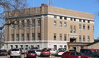 Merrick County courthouse in Central City
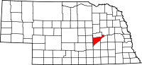
Location in the state of Nebraska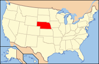
Nebraska's location in the U.S.Founded 1858 Named for Elvira Merrick Seat Central City Largest city Central City Area
- Total
- Land
- Water
495 sq mi (1,282 km²)
10 sq mi (26 km²), 1.99%Population
- (2000)
- Density
8,204
18/sq mi (7/km²)Website www.merrickcounty.ne.gov Merrick County is a county located in the U.S. state of Nebraska. As of 2010, the population was 7,845[1], a decline of 4.4% from the 2000 population of 8,204. Its county seat is Central City[2].
Merrick County is part of the Grand Island, Nebraska Micropolitan Statistical Area.
In the Nebraska license plate system, Merrick County is represented by the prefix 46 (it had the forty-sixth-largest number of vehicles registered in the county when the license plate system was established in 1922).
Contents
History
Merrick County was formed in 1858. It was named for Elvira Merrick, the maiden name of the wife of territorial legislator Henry W. DePuy, who introduced the bill creating the county.[3]
When first formed, the county was bounded on the south by the Platte River, and by straight lines on the north, east, and west. It thus included 180 square miles (470 km2) of the Pawnee Reservation, established one year before the county. In 1873, the state legislature removed these reservation lands from the county, leaving it with a jagged northern border from which narrow panhandles extended northward from the northeast and northwest corners. In 1897, the Pawnee Reservation became Nance County.[4]
Geography
According to the U.S. Census Bureau, the county has a total area of 495 square miles (1,281 km²), of which, 485 square miles (1,256 km²) of it is land and 10 square miles (26 km²) of it (1.99%) is water.
Major highways
Adjacent counties
- Platte County, Nebraska - (Northeast)
- Polk County, Nebraska - (East)
- Hamilton County, Nebraska - (South)
- Hall County, Nebraska - (Southwest)
- Howard County, Nebraska - (West)
- Nance County, Nebraska - (North)

Nance County Platte County Howard County 
Polk County  Merrick County, Nebraska

Hall County Hamilton County Demographics
Merrick County
Population by decade1860 - 109
1870 - 557
1880 - 5,341
1890 - 8,758
1900 - 9,255
1910 - 10,379
1920 - 10,763
1930 - 10,619
1940 - 9,354
1950 - 8,812
1960 - 8,363
1970 - 8,751
1980 - 8,945
1990 - 8,049
2000 - 8,204As of the census[5] of 2000, there were 8,204 people, 3,209 households, and 2,307 families residing in the county. The population density was 17 people per square mile (7/km²). There were 3,649 housing units at an average density of 8 per square mile (3/km²). The racial makeup of the county was 98.32% White, 0.22% Black or African American, 0.10% Native American, 0.21% Asian, 0.01% Pacific Islander, 0.67% from other races, and 0.48% from two or more races. 2.05% of the population were Hispanic or Latino of any race.
There were 3,209 households out of which 33.30% had children under the age of 18 living with them, 61.10% were married couples living together, 6.50% had a female householder with no husband present, and 28.10% were non-families. 25.00% of all households were made up of individuals and 13.10% had someone living alone who was 65 years of age or older. The average household size was 2.51 and the average family size was 2.99.
In the county the population was spread out with 27.50% under the age of 18, 6.40% from 18 to 24, 24.70% from 25 to 44, 23.80% from 45 to 64, and 17.50% who were 65 years of age or older. The median age was 39 years. For every 100 females there were 95.90 males. For every 100 females age 18 and over, there were 94.90 males.
The median income for a household in the county was $34,961, and the median income for a family was $39,729. Males had a median income of $26,998 versus $19,828 for females. The per capita income for the county was $15,958. About 7.00% of families and 8.90% of the population were below the poverty line, including 9.70% of those under age 18 and 9.20% of those age 65 or over.
Communities
City
Villages
Other place
Townships
- Central
- Chapman
- Clarksville
- Lone Tree
- Loup
- Mead
- Midland
- Prairie Creek
- Prairie Island
- Silver Creek
- Vieregg
See also
References
- ^ "Mapping the 2010 U.S. Census". The New York Times. http://projects.nytimes.com/census/2010/map?hp. Retrieved 3-26-2011.
- ^ "Find a County". National Association of Counties. http://www.naco.org/Counties/Pages/FindACounty.aspx. Retrieved 2011-06-07.
- ^ "Records of Merrick County among holdings of NSHS Library, Lincoln, NE". NEGenWeb Project. Retrieved 2009-12-28.
- ^ "Merrick County's 100th Year: 1858-1958". NEGenWeb Project. Retrieved 2009-12-28.
- ^ "American FactFinder". United States Census Bureau. http://factfinder.census.gov. Retrieved 2008-01-31.
Municipalities and communities of Merrick County, Nebraska City 
Villages Chapman | Clarks | Palmer | Silver Creek
Townships Central | Chapman | Clarksville | Lone Tree | Loup | Mead | Midland | Prairie Creek | Prairie Island | Silver Creek | Vieregg
Unincorporated
communityCategories:- Nebraska counties
- Merrick County, Nebraska
- Grand Island micropolitan area


Wikimedia Foundation. 2010.