- Hillsborough County, New Hampshire
-
Hillsborough County, New Hampshire 
Seal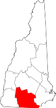
Location in the state of New Hampshire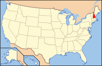
New Hampshire's location in the U.S.Founded 1769 Seat Manchester and Nashua Largest city Manchester Area
- Total
- Land
- Water
892 sq mi (2,310 km²)
876 sq mi (2,269 km²)
16 sq mi (41 km²), 1.78%Population
- (2010)
- Density
400,721
458/sq mi (177/km²)Website www.hillsboroughcountynh.org Hillsborough County is the most populous county in the U.S. state of New Hampshire. As of 2010, the population was 400,721.[1] Its county seats are Manchester and Nashua. Hillsborough is northern New England's most populous county as well as its most densely populated.
Contents
History
Hillsborough was one of the five original counties identified for New Hampshire in 1769, and was named for Wills Hill, the Viscount Hillsborough who was British Secretary of State for the Colonies at the time. The county was organized at Amherst on March 19, 1771. In 1823 a number of towns were removed to become part of Merrimack County. Over several years ending in 1869, county administrative functions were moved from Amherst first to Milford in 1866 then to the current seats of Manchester and Nashua.
Geography
According to the U.S. Census Bureau, the county has a total area of 892 square miles (2,310 km2), of which 876 sq mi (2,270 km2) is land and 16 sq mi (41 km2) (1.78%) is water. The highest point in Hillsborough county is Pack Monadnock Mountain at 2,290 feet (700 m).
Adjacent counties
- Merrimack County (north)
- Rockingham County (east)
- Essex County, Massachusetts (southeast)
- Middlesex County, Massachusetts (south)
- Worcester County, Massachusetts (southwest)
- Cheshire County (west)
- Sullivan County (northwest)

Sullivan County Merrimack County Cheshire County 
Rockingham County  Hillsborough County, New Hampshire

Worcester County, Massachusetts Middlesex County, Massachusetts Essex County, Massachusetts National protected area
- Wapack National Wildlife Refuge
Demographics
Historical populations Census Pop. %± 1790 32,883 — 1800 43,899 33.5% 1810 49,249 12.2% 1820 53,884 9.4% 1830 37,724 −30.0% 1840 42,494 12.6% 1850 57,478 35.3% 1860 62,140 8.1% 1870 64,238 3.4% 1880 75,634 17.7% 1890 93,247 23.3% 1900 112,640 20.8% 1910 126,072 11.9% 1920 135,512 7.5% 1930 140,165 3.4% 1940 144,888 3.4% 1950 156,987 8.4% 1960 178,161 13.5% 1970 223,941 25.7% 1980 276,608 23.5% 1990 336,073 21.5% 2000 380,841 13.3% 2010 400,721 5.2% [2][3][4] As of the census[5] of 2000, there were 380,841 people, 144,455 households, and 98,807 families residing in the county. The population density was 435 people per square mile (168/km²). There were 149,961 housing units at an average density of 171 per square mile (66/km²). The racial makeup of the county was 93.90% White, 1.29% Black or African American, 0.25% Native American, 2.00% Asian, 0.03% Pacific Islander, 1.31% from other races, and 1.22% from two or more races. 3.19% of the population were Hispanic or Latino of any race. 15.4% were of Irish, 13.7% French Canadian, 12.5% French, 10.1% English, 7.5% Italian, 6.0% American and 5.7% German ancestry according to Census 2000. 87.6% spoke English, 5.1% French and 2.7% Spanish as their first language.
There were 144,455 households out of which 35.10% had children under the age of 18 living with them, 55.00% were married couples living together, 9.50% had a female householder with no husband present, and 31.60% were non-families. 24.30% of all households were made up of individuals and 7.80% had someone living alone who was 65 years of age or older. The average household size was 2.58 and the average family size was 3.10.
In the county the population was spread out with 26.30% under the age of 18, 7.70% from 18 to 24, 32.70% from 25 to 44, 22.60% from 45 to 64, and 10.60% who were 65 years of age or older. The median age was 36 years. For every 100 females there were 97.30 males. For every 100 females age 18 and over, there were 94.70 males.
The median income for a household in the county was $53,384, and the median income for a family was $62,363. Males had a median income of $42,017 versus $29,397 for females. The per capita income for the county was $25,198. About 4.30% of families and 6.30% of the population were below the poverty line, including 7.60% of those under age 18 and 8.20% of those age 65 or over.
Cities, towns, and villages*
* Villages are census divisions, but have no separate corporate existence from the towns they are in.
Politics
Presidential election results[6] Year Democrat Republican 2008 51.2% 104,820 47.5% 97,178 2004 48.1% 94,121 51.0% 99,724 2000 46.8% 77,625 48.7% 80,649 See also
References
- ^ United States Census Bureau, American FactFinder, 2010 Census figures. Retrieved March 23, 2011.
- ^ http://www.census.gov/population/www/censusdata/cencounts/files/nh190090.txt
- ^ http://factfinder2.census.gov/faces/tableservices/jsf/pages/productview.xhtml?pid=DEC_10_PL_QTPL&prodType=table
- ^ http://mapserver.lib.virginia.edu/
- ^ "American FactFinder". United States Census Bureau. http://factfinder.census.gov. Retrieved 2008-01-31.
- ^ "Dave Leip's Atlas of U.S. Presidential Elections". http://uselectionatlas.org/RESULTS/. Retrieved 2011-06-11.
External links
- Hillsborough County web site
- National Register of Historic Places listing for Hillsborough County
- Hillsborough County Sheriff Office
Municipalities and communities of Hillsborough County, New Hampshire Cities 
Towns Amherst | Antrim | Bedford | Bennington | Brookline | Deering | Francestown | Goffstown | Greenfield | Greenville | Hancock | Hillsborough | Hollis | Hudson | Litchfield | Lyndeborough | Mason | Merrimack | Milford | Mont Vernon | New Boston | New Ipswich | Pelham | Peterborough | Sharon | Temple | Weare | Wilton | Windsor
Villages East Merrimack | Grasmere | Pinardville
Categories:- New Hampshire counties
- Hillsborough County, New Hampshire
- States and territories established in 1769


Wikimedia Foundation. 2010.