- Georgia State Route 104
Infobox road
state=GA
type=
route=104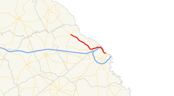
previous_route=103
next_route=105Georgia State Route 104 is a spur route of its parent, GA 4. It is more commonly referred to as both
River Watch Parkway andWashington Road in theAugusta, Georgia area.Highway 104 begins in downtown Augusta at the intersection of Reynolds and 13th Streets (
Georgia State Route 4 ) and heads northwestward into suburban Columbia County. In Richmond County, the highway is known as River Watch Parkway. Near the line between Richmond and Columbia counties, River Watch Parkway intersects with Pleasant Home Road, which allows quick access to Washington Road. The distance between River Watch Parkway and Washington Road at this intersection is less than 1/8 mile. Highway 104 then continues northwestward on Washington Road through much of Columbia County. Highway 104 ends at a five-point intersection in northern Columbia County in an area known asPollard's Corner . This area is located just south ofLake Strom Thurmond .River Watch Parkway was originally constructed in the late 1980s and early 1990s to relieve heavy rush-hour traffic on congested Washington Road and John C. Calhoun Expressway, which many Augusta area residents used (and continue to use) to travel to and from work. Much of the parkway from downtown Augusta to near its intersection with
Interstate 20 is undeveloped and offers scenic views of theAugusta Canal andSavannah River . A large lifestyle center is being developed just south of Interstate 20 to be known as The Village at River Watch. The development is expected to contain a mix of retail, dining, lodging, and entertainment facilities.From just north of Interstate 20 to the intersection of Stevens Creek Road in northern Richmond County, the parkway is fairly industrial mixed with lodging facilities. Between Stevens Creek Road and Fury's Ferry Road (
Georgia State Route 28 ), there is a noticeable lack of development alongside the road, primarily because of the close proximity of a railroad track. The distance between Stevens Creek Road and Fury's Ferry Road is slightly less than one mile.The next intersection is the aforementioned Pleasant Home Road. Although River Watch Parkway continues for about another 1/2 mile to Baston Road, drivers must turn left onto Pleasant Home Road and then take an immediate right onto Washington Road if they wish to continue traveling west on Highway 104. After the intersection with Baston Road, River Watch Parkway becomes Old Petersburg Road, and has no highway designation.
In future plans, Old Petersburg Road will be widened all the way to its intersection with Old Evans Road in
Martinez, Georgia . Then a new road will be constructed to continue the path to the town center of Evans in Columbia County. It remains unclear whether this project will carry the name River Watch Parkway, or if it will have any state route designation. The goal of this project is to make driving easier, safer, and faster from the ever expanding westward population migration to and from downtown Augusta.Georgia State Route 104 becomes Washington Road near the Richmond-Columbia County line. Washington Road is a well-known thoroughfare in the Augusta metropolitan area. One of its most congested areas is in the heart of Martinez, near the intersection with
Bobby Jones Expressway and Old Evans Road. Shortly after this congested intersection, Highway 104 also intersects with State Route 232, also known as Columbia Road. Then, as drivers head westward, Washington Road takes a decided turn to the northwest towardEvans, Georgia , where it intersects with Belair Road (State Route 383). After passing through the Evans town center, Washington Road (State Route 104) progresses northwestward into gradually more and more of a rural setting. The road dwindles from five lanes to two just west of its intersection with Blanchard Road, and for the most part, continues as two to three lanes all the way to Pollard's Corner.
Wikimedia Foundation. 2010.