- N3 road (Ireland)
-
N3 road
Route information Length: 205 km (127 mi) Location Primary
destinations:(bypassed routes in italics)
- County Dublin
- County Meath
- Clonee
- Dunshaughlin
- Ross Cross
- Navan
- Kells
- Carnaross
- County Cavan
- Lisduff
- Virginia
- New Inn
- Cavan Town
- Butlersbridge
- Belturbet
- County Donegal
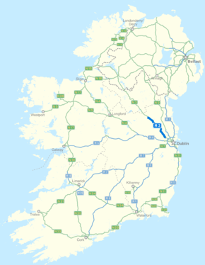
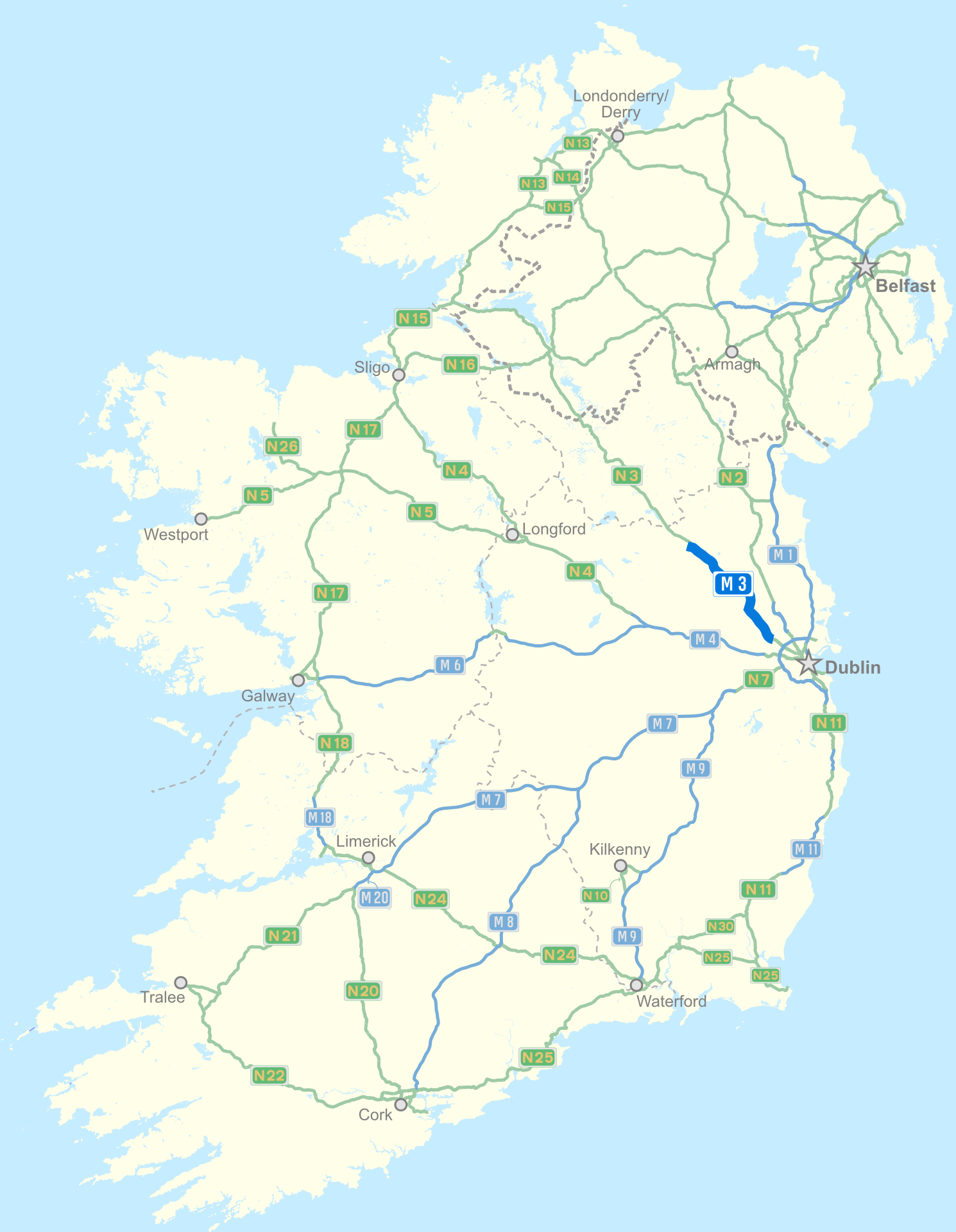
Road network The N3 road is a national primary road in Ireland, running between Dublin, Cavan and the border with County Fermanagh. The A509 and A46 roads in Northern Ireland form part of an overall route connecting to Enniskillen, and northwest to the border again where the N3 reappears to serve Ballyshannon in County Donegal.
Rush hour congestion between Navan and Dublin city is very heavy (up to 22,000 vehicles per day on parts of the N3 in 2002), and problems occur at most built-up areas between these points. A tolled motorway bypass replacement, the M3 motorway, was opened to traffic on the 4th of June 2010. The bypassed section from Clonee to the border with County Cavan has been reclassified as the R147.
Contents
Route
 The old N3, between Clonee and Dunshaughlin
The route is known as the Navan Road as it leaves Dublin, passing near the Phoenix Park's northeastern exit and bypassing Castleknock.
It passes through a major junction with the M50 motorway and then bypasses Blanchardstown, Mulhuddart and Clonee with a dual carriageway. The dual carriageway changes into the M3 motorway near the Meath border by-passing Dunshaughlin and Navan. Near Kells the route continues as the N3 dual carriage way to the border with County Cavan. It then passes through Virginia, past Cavan Town and continues past Butlersbridge and through Belturbet. The route then crosses the border with Northern Ireland, becoming the A509 to Enniskillen. The A46 road connects Enniskillen and the Donegal border, becoming the N3 across the border at Belleek, and connecting to Ballyshannon.
N3 upgrade
The National Roads Authority in conjunction with Cavan and Donegal County Councils plan major improvements to the N3 route in Ulster. It is currently planned that the Virginia bypass will be developed as 12.5 kilometres of type two dual carriageway. Type two dual carriageway has reduced width or no hard shoulders and also a reduced width median. This approach significantly cuts land acquisition costs.
M3 motorway
M3 motorway

 Clickable image
Route information Part of 
Length: 51 km (32 mi) Existed: 2007 – present History: Completed in 2010 Major junctions N52, N51 To: Kells, County Meath Location Primary
destinations:Dunboyne, Dunshaughlin, Navan, Kells Road network Part of the old N3 route has been bypassed by the construction of 51 kilometres of new motorway. This stretch of motorway, designated M3, was opened on June 4, 2010. The M3 begins near the end of the dual carriageway outside Clonee and terminates south west of Kells just before the N52. The entire scheme does not terminate at this point as a new realigned N3 continues to bypass Kells before terminating near the County Cavan border. The scheme also includes the N52 Kells northern bypass. Since completion, the M3 now bypasses Dunshaughlin, Navan, and Kells.
Controversy
The motorway was contested because the route passes near the Hill of Tara and through the archaeologically rich Tara-Skryne valley or Gabhra. The planned route corridor was approved by An Bord Pleanála (Ireland's planning appeals board) in August 2003.[1][2]
Motorway reclassification
On 30 September 2008, the Department of Transport announced the second round of proposed motorway reclassifications under the Roads Act 2007. A short section of the existing dual-carriageway N3 bypassing Clonee, from northwest of Mulhuddart to the start of the M3 toll motorway scheme, is affected by this. Following a public consultation process, on 10 July 2009 the Minister for Transport, Noel Dempsey, made a Statutory Instrument reclassifying this section of the N3 as motorway effective from 28 August 2009.[3] It was the first section of M3 to come into being.
Motorway project details
- The most expensive single contract road project ever undertaken in Ireland coming in at approximately €650 million according to SIAC.
- It is tolled at two locations, one point north of Navan and another point between Dunshaughlin and Clonee for 45 years running from 2007. The Government have the option to buy out this contract at any time. The price level of tolls is controlled by the Board of the NRA and they can reduce, increase or remove the tolls as they see appropriate (as is the case with every other toll road in Ireland e.g. Dublin Port Tunnel weekend price reduction). Should they lower the tolls on the M3 the government would have to make up the difference of what is owed yearly to Eurolink M3 Ltd through tax revenue. Thus Eurolink are guaranteed a certain agreed return from their investment and would not suffer from any reduction in toll revenue from either a toll reduction or the planned opening of the Navan rail line. The toll revenue is collected by a private company on behalf of the state as a means to pay the private sector consortium annually for their initial once off investment in constructing the road.
- It is the longest road project ever to be constructed in Ireland including nearly 100 kilometres of new or upgraded road including 49 km of new M3, 10 km of new N3, 20 km of new link roads and interchanges, and approximately 15 kilometres of local road improvements, footpaths, cycle lanes and new bridges.
- It was originally planned to open in 2006.
- An Bord Pleanála initially approved the project on 22 August 2003. Exactly 4 years later, on 22 August 2007, they directed that the excavation of the Lismullin monument did not require fresh planning approval.
Junctions
N3 Dual Carriageway Northbound exit Junction Southbound exit M50 motorway  : Dublin Port, Bray and ALL OTHER ROUTES (M50)
M50 motorway : Dublin Port, Bray and ALL OTHER ROUTES (M50)

Clonee, Damastown 
End of motorway M3 motorway Northbound exit Junction Southbound exit Start of motorway Clonee, Damastown Pace Interchange: Dunboyne, Trim (R154), Ratoath (R155) 
Pace Interchange: Dunboyne, Trim (R154), Ratoath (R155) 
Dunshaughlin, Kilcock 
Dunshaughlin, Kilcock Skryne (R147), Johnstown 
Skryne (R147), Johnstown Navan (South) 
Navan (South) Navan (North), Delvin, Athboy (N51) 
Navan (North), Delvin, Athboy (N51) Kells 
Kells End of motorway Start of motorway Road continues as N3 for Cavan, Enniskillen and Ballyshannon See also
- Roads in Ireland
- Motorways in Ireland
- National secondary road
- Regional road
- National Development Plan
- History of roads in Ireland
- National Roads Authority
References
- ^ Eileen Battersby (26 May 2007). "Is nothing sacred?". The Irish Times.
- ^ Glenn Frankel (22 January 2005). "In Ireland, Commuters vs. Kings". The Washington Post: p. A01. http://www.washingtonpost.com/wp-dyn/articles/A27671-2005Jan21.html. Retrieved 2007-06-14.
- ^ http://www.transport.ie/upload/general/10978-SI_255_OF_2009-0.PDF
External links
- Official M3 website
- NRA project page for M3 motorway
- Zoney Irish Roads website
- Website of group of people working to re-route the M3
- BBC News article
- Washington Post article
Roads in Ireland Motorways National primary roads National secondary roads Regional roads (R101–R399) R101 · R102 · R103 · R104 · R105 · R106 · R107 · R108 · R109 · R110 · R111 · R112 · R113 · R114 · R115 · R116 · R117 · R118 · R119 · R120 · R121 · R122 · R123 · R124 · R125 · R126 · R127 · R128 · R129 · R130 · R131 · R132 · R133 · R134 · R135 · R136 · R148 · R149 · R150 · R151 · R152 · R153 · R154 · R155 · R156 · R157 · R158 · R159 · R160 · R161 · R162 · R163 · R164 · R165 · R166 · R167 · R168 · R169 · R170 · R171 · R172 · R173 · R174 · R175 · R176 · R177 · R178 · R179 · R180 · R181 · R182 · R183 · R184 · R185 · R186 · R187 · R188 · R189 · R190 · R191 · R192 · R193 · R194 · R195 · R196 · R197 · R198 · R199 · R200 · R201 · R202 · R203 · R204 · R205 · R206 · R207 · R208 · R209 · R210 · R211 · R212 · R213 · R214 · R229 · R230 · R231 · R232 · R233 · R234 · R235 · R236 · R237 · R238 · R239 · R240 · R241 · R242 · R243 · R244 · R245 · R246 · R247 · R248 · R249 · R250 · R251 · R252 · R253 · R254 · R255 · R256 · R257 · R258 · R259 · R260 · R261 · R262 · R263 · R264 · R265 · R266 · R267 · R268 · R277 · R278 · R279 · R280 · R281 · R282 · R283 · R284 · R285 · R286 · R287 · R288 · R289 · R290 · R291 · R292 · R293 · R294 · R295 · R296 · R297 · R298 · R299 · R310 · R311 · R312 · R313 · R314 · R315 · R316 · R317 · R318 · R319 · R320 · R321 · R322 · R323 · R324 · R325 · R326 · R327 · R328 · R329 · R330 · R331 · R332 · R333 · R334 · R335 · R336 · R337 · R338 · R339 · R340 · R341 · R342 · R343 · R344 · R345 · R346 · R347 · R348 · R349 · R350 · R351 · R352 · R353 · R355 · R356 · R357 · R358 · R359 · R360 · R361 · R362 · R363 · R364 · R365 · R366 · R367 · R368 · R369 · R370 · R371 · R372 · R373 · R374 · R375 · R376 · R377 · R378 · R379 · R389 · R390 · R391 · R392 · R393 · R394 · R395 · R396 · R397 · R398 · R399Regional roads (R400–R699) R400 · R401 · R402 · R403 · R404 · R405 · R406 · R407 · R408 · R409 · R410 · R411 · R412 · R413 · R414 · R415 · R416 · R417 · R418 · R419 · R420 · R421 · R422 · R423 · R424 · R425 · R426 · R427 · R428 · R429 · R430 · R431 · R432 · R433 · R434 · R435 · R436 · R437 · R438 · R439 · R440 · R441 · R442 · R443 · R444 · R445 · R446 · R448 · R449 · R458 · R459 · R460 · R461 · R462 · R463 · R464 · R465 · R466 · R467 · R468 · R469 · R470 · R471 · R472 · R473 · R474 · R475 · R476 · R477 · R478 · R479 · R480 · R481 · R482 · R483 · R484 · R485 · R486 · R487 · R488 · R489 · R490 · R491 · R492 · R493 · R494 · R495 · R496 · R497 · R498 · R499 · R500 · R501 · R502 · R503 · R504 · R505 · R506 · R507 · R509 · R510 · R511 · R512 · R513 · R514 · R515 · R516 · R517 · R518 · R519 · R520 · R521 · R522 · R523 · R524 · R525 · R526 · R527 · R548 · R549 · R550 · R551 · R552 · R553 · R554 · R555 · R556 · R557 · R558 · R559 · R560 · R561 · R563 · R564 · R565 · R566 · R567 · R568 · R569 · R570 · R571 · R572 · R573 · R574 · R575 · R576 · R577 · R578 · R579 · R580 · R581 · R582 · R583 · R584 · R585 · R586 · R587 · R588 · R589 · R590 · R591 · R592 · R593 · R594 · R595 · R596 · R597 · R598 · R599 · R600 · R601 · R602 · R603 · R604 · R605 · R606 · R607 · R608 · R609 · R610 · R611 · R612 · R613 · R614 · R615 · R616 · R617 · R618 · R619 · R620 · R621 · R622 · R623 · R624 · R626 · R627 · R628 · R629 · R630 · R631 · R632 · R633 · R634 · R635 · R637 · R638 · R639 · R659 · R660 · R661 · R662 · R663 · R664 · R665 · R666 · R667 · R668 · R669 · R670 · R671 · R672 · R673 · R674 · R675 · R676 · R677 · R678 · R679 · R680 · R681 · R682 · R683 · R684 · R685 · R686 · R687 · R688 · R689 · R690 · R691 · R692 · R693 · R694 · R695 · R696 · R697 · R698 · R699Regional roads (R700–R940) R700 · R701 · R702 · R703 · R704 · R705 · R706 · R707 · R708 · R709 · R710 · R724 · R725 · R726 · R727 · R729 · R730 · R731 · R733 · R734 · R735 · R736 · R737 · R738 · R739 · R740 · R741 · R742 · R743 · R744 · R745 · R746 · R747 · R748 · R749 · R750 · R751 · R752 · R753 · R754 · R755 · R756 · R757 · R758 · R759 · R760 · R761 · R762 · R763 · R764 · R765 · R766 · R767 · R768 · R769 · R770 · R772 · R773 · R774 · R801 · R802 · R803 · R804 · R805 · R806 · R807 · R808 · R809 · R810 · R811 · R812 · R813 · R814 · R815 · R816 · R817 · R818 · R819 · R820 · R821 · R822 · R824 · R825 · R826 · R827 · R828 · R829 · R830 · R831 · R833 · R834 · R835 · R836 · R837 · R838 · R839 · R840 · R841 · R842 · R843 · R846 · R847 · R848 · R849 · R851 · R852 · R853 · R854 · R855 · R857 · R858 · R859 · R860 · R863 · R864 · R865 · R866 · R867 · R868 · R870 · R871 · R873 · R874 · R875 · R876 · R877 · R880 · R883 · R884 · R885 · R886 · R887 · R888 · R889 · R890 · R891 · R895 · R896 · R898 · R899 · R900 · R901 · R902 · R903 · R904 · R906 · R907 · R908 · R909 · R910 · R911 · R913 · R914 · R915 · R916 · R917 · R918 · R919 · R920 · R921 · R922 · R923 · R924 · R925 · R926 · R927 · R928 · R929 · R930 · R931 · R932 · R933 · R934 · R935 · R936 · R937 · R940Categories:- National primary roads in the Republic of Ireland
- Roads in County Dublin
- Roads in County Meath
- Roads in County Cavan
- Roads in County Donegal


Wikimedia Foundation. 2010.