- Berks County, Pennsylvania
-
Berks County, Pennsylvania 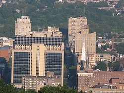 Reading skyline
Seal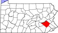
Location in the state of Pennsylvania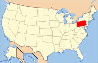
Pennsylvania's location in the U.S.Founded March 11, 1752 Seat Reading Largest city Reading Area
- Total
- Land
- Water
866 sq mi (2,243 km²)
859 sq mi (2,225 km²)
7 sq mi (18 km²), 0.78%Population
- (2010)
- Density
411,442
479/sq mi (184.9/km²)Website www.co.berks.pa.us Berks County is a county located in the U.S. state of Pennsylvania. As of the 2010 census, the population was 411,442. The county seat is Reading.[1] Berks County is part of the Reading, PA, metropolitan statistical area and as of 2005, is also considered part of the Philadelphia combined statistical area.
Contents
History
Reading developed during the 1740s when the inhabitants of northern Lancaster County sent several petitions requesting that a separate county be established. With the help of German immigrant Conrad Weiser, the county was formed on March 11, 1752 from parts of Chester County, Lancaster County, and Philadelphia County.
It was named after the English county in which William Penn's family home lay - Berkshire, which is often abbreviated to Berks. Berks County began much larger than it is today. The northwestern parts of the county went to the founding of Northumberland County in 1772 and Schuylkill County in 1811, when it reached its current size. In 2005, Berks County was added to the Delaware Valley Planning Area due to a fast-growing population and close proximity to the other communities.
Law and government
 Berks County Courthouse
County Commissioners
- Mark C. Scott, Chairman, Republican
- Kevin Barnhardt, Democrat
- Christian Leinbach, Republican
Other county offices
- Clerk of Courts, James P. Troutman, Republican
- Controller, Sandy Graffius, Republican
- Coroner, Dennis J. Hess, Democrat
- District Attorney, John T. Adams, Democrat
- Prothonotary, Marianne Sutton, Republican
- Recorder of Deeds, Frederick Sheeler, Democrat
- Register of Wills, Larry J. Medaglia Jr., Republican
- Sheriff, Eric Weaknecht, Republican
- Treasurer, Nelson H. Long, Republican
Pennsylvania State Senate
- Judy Schwank, Democrat, Pennsylvania Senate, District 11
- Dave Argall, Republican, Pennsylvania Senate, District 29
- John C. Rafferty Jr., Republican, Pennsylvania Senate, District 44
- Mike Folmer, Republican, Pennsylvania Senate, District 48
Pennsylvania House of Representatives
- Jerry Knowles, Republican, Pennsylvania House of Representatives, District 124
- Mike Tobash, Republican, Pennsylvania House of Representatives, District 125
- Dante Santoni Jr., Democrat, Pennsylvania House of Representatives, District 126
- Thomas R. Caltagirone, Democrat, Pennsylvania House of Representatives, District 127
- Mark Gillen, Republican, Pennsylvania House of Representatives, District 128
- Jim Cox, Republican, Pennsylvania House of Representatives, District 129
- David Maloney, Republican, Pennsylvania House of Representatives, District 130
- Doug Reichley, Republican, Pennsylvania House of Representatives, District 134
- Gary Day, Republican, Pennsylvania House of Representatives, District 187
United States House of Representatives
- Jim Gerlach, Republican, Pennsylvania's 6th congressional district
- Charlie Dent, Republican, Pennsylvania's 15th congressional district (Hereford 2 only)
- Joseph Pitts, Republican, Pennsylvania's 16th congressional district
- Tim Holden, Democrat, Pennsylvania's 17th congressional district
United States Senate
Geography
According to the U.S. Census Bureau, the county has a total area of 866 square miles (2,242.9 km2). 859 square miles (2,224.8 km2) is land and 7 square miles (18.1 km2) (0.78%) is water. Most of the county is drained by the Schuylkill River, but an area in the northeast is drained by the Lehigh River via the Little Lehigh Creek and areas are drained by the Susquehanna River via the Swatara Creek in the northwest and the Conestoga River (which starts in Berks County between Morgantown and Elverson) in the extreme south.
Adjacent counties
- Schuykill County (north)
- Lehigh County (northeast)
- Montgomery County (east)
- Chester County (southeast)
- Lancaster County (southwest)
- Lebanon County (west)

Schuylkill County Lehigh County Lebanon County 
Montgomery County  Berks County, Pennsylvania

Lancaster County Chester County National protected area
Demographics
Historical populations Census Pop. %± 1790 30,189 — 1800 32,407 7.3% 1810 43,146 33.1% 1820 46,275 7.3% 1830 53,152 14.9% 1840 64,569 21.5% 1850 77,129 19.5% 1860 93,818 21.6% 1870 106,701 13.7% 1880 122,597 14.9% 1890 137,327 12.0% 1900 159,615 16.2% 1910 183,222 14.8% 1920 200,854 9.6% 1930 231,717 15.4% 1940 241,884 4.4% 1950 255,740 5.7% 1960 275,414 7.7% 1970 296,382 7.6% 1980 312,509 5.4% 1990 336,523 7.7% 2000 373,638 11.0% 2010 411,442 10.1% [2][3] As of the census[4] of 2000, there were 373,638 people, 141,570 households, and 98,532 families residing in the county. The population density was 435 people per square mile (168/km²). There were 150,222 housing units at an average density of 175 per square mile (68/km²). The racial makeup of the county in 2004 was 82.5% White, 4.6% Black or African American, 0.2% Native American, 1.2% Asian, 0.02% Pacific Islander, 6.3% from other races, and 1.2% from two or more races. Hispanic or Latino of any race made up 11.8%. 35.1% were of German, 8.6% Italian, 7.1% Irish, and 5.4% Polish ancestry according to Census 2000. 87.6% spoke English, 8.1% Spanish and 1.0% Pennsylvania Dutch as their first language. Historically there was a large Pennsylvania Dutch (from Pennsylvania Deutsch or German) population. It is known as part of Pennsylvania Dutch Country. Berks County also has large and growing Puerto Rican, Dominican, and Mexican communities.
According to Muninetguide the median household income for Berks County, as of 2010, is $54,105
There were 141,570 households out of which 31.70% had children under the age of 18 living with them, 55.50% were married couples living together, 9.90% had a female householder with no husband present, and 30.40% were non-families. 24.60% of all households were made up of individuals and 10.70% had someone living alone who was 65 years of age or older. The average household size was 2.55 and the average family size was 3.05.
In the county, the population was spread out with 24.60% under the age of 18, 8.80% from 18 to 24, 28.90% from 25 to 44, 22.60% from 45 to 64, and 15.00% who were 65 years of age or older. The median age was 37 years. For every 100 females there were 95.90 males. For every 100 females age 18 and over, there were 92.70 males.
Politics
As of January 2010, there are 248,949 registered voters in Berks County.[5]
- Democratic: 121,828 (48.94%)
- Republican: 92,685 (37.23%)
- Other parties: 34,436 (13.83%)
The first time since 1964 that a Democrat carried Berks in a Presidential election occurred in November 2008, with Barack Obama receiving 53.9% of the vote to John McCain's 44.7%. The other three statewide winners (Rob McCord for Treasurer, Jack Wagner for Auditor General, and Tom Corbett for Attorney General) also carried it.[6] While Republicans have controlled the commissioner majority most of the time and continue to control most county row offices, Democrats have become more competitive in Berks in recent years.
Municipalities
 Map of Berks County, Pennsylvania with Municipal Labels showing Cities and Boroughs (red), Townships (white), and Census-designated places (blue).
Under Pennsylvania law, there are four types of incorporated municipalities: cities, boroughs, townships, and, in at most two cases, towns. The following cities, boroughs and townships are located in Berks County:
Cities
Boroughs
Townships
 A farm in Windsor Township
- Albany Township
- Alsace Township
- Amity Township
- Bern Township
- Bethel Township
- Brecknock Township
- Caernarvon Township
- Centre Township
- Colebrookdale Township
- Cumru Township
- District Township
- Douglass Township
- Earl Township
- Exeter Township
- Greenwich Township
- Heidelberg Township
- Hereford Township
- Jefferson Township
- Longswamp Township
- Lower Alsace Township
- Lower Heidelberg Township
- Maidencreek Township
- Marion Township
- Maxatawny Township
- Muhlenberg Township
- North Heidelberg Township
- Oley Township
- Ontelaunee Township
- Penn Township
- Perry Township
- Pike Township
- Richmond Township
- Robeson Township
- Rockland Township
- Ruscombmanor Township
- South Heidelberg Township
- Spring Township
- Tilden Township
- Tulpehocken Township
- Union Township
- Upper Bern Township
- Upper Tulpehocken Township
- Washington Township
- Windsor Township
Unincorporated or Census-designated places
Census-designated places are geographical areas designated by the U.S. Census Bureau for the purposes of compiling demographic data. They are not actual jurisdictions under Pennsylvania law. Other unincorporated communities, such as villages, may be listed here as well.
- Amity Gardens
- Flying Hills
- Lorane
- Plowville
- Reiffton
Education
Colleges and universities
- Albright College
- Alvernia University
- Kutztown University of Pennsylvania
- Penn State Berks
- Reading Area Community College
 Map of Berks County, Pennsylvania Public School Districts
Public school districts
- Antietam School District
- Boyertown Area School District
- Brandywine Heights Area School District
- Conrad Weiser Area School District
- Daniel Boone Area School District
- Exeter Township School District
- Fleetwood Area School District
- Governor Mifflin School District
- Hamburg Area School District
- Kutztown Area School District
- Muhlenberg School District
- Oley Valley School District
- Reading School District
- Schuylkill Valley School District
- Tulpehocken Area School District
- Twin Valley School District
- Upper Perkiomen School District
- Wilson School District
- Wyomissing Area School District
Private high schools
- Berks Christian School [1]
- Blue Mountain Academy
- Fairview Christian School
- Kings Academy
- Berks Catholic High School
Technical or trade schools
- Berks Technical Institute
- Pace Institute
- Reading Hospital School of Nursing
Notable people
- Gus Yatron, Former United States Congressman from Pennsylvania
- William Addams, United States Congressman from Pennsylvania[7]
- Daniel Boone, American pioneer, explorer, and frontiersman (b. 1734 - d. 1820)
- Bodo Otto, Senior Surgeon of the Continental Army during the American Revolution (b. 1711 - d. 1787)
- Priscilla Ahn, folk musician and singer-songwriter.
- Chad Billingsley, pitcher for the LA Dodgers
- Steve Burns, musician and former Blue's Clues host
- Bob Cesca, animator, political author and columnist/blogger for The Huffington Post
- Jack Coggins, illustrator, author and artist, lived in Boyertown from 1948–2006
- Rocky Colavito, former Major League Baseball player
- Kerry Collins, professional football player (Panthers, Saints, Giants, Raiders, Titans, and Colts)
- Michael Constantine, actor, star of Room 222 and My Big Fat Greek Wedding.
- John Henry Gilmore, Jr., professional football player (Saints, Bears, and Buccaneers)
- Kate Gosselin, Gosselin Family, Reality TV stars of Jon & Kate Plus 8
- Chad Henne, professional football player (Miami Dolphins) and Graduate of the University of Michigan (4 Year Starter at Quarterback)
- Chris Hero, professional wrestler
- Joseph Hiester, governor of Pennsylvania 1820-1823
- Tommy Hinnershitz 1912-1999. Auto racing pioneer. Member Pennsylvania Sports Hall of Fame.
- Chad Hurley, Co-Founder of YouTube (attended Twin Valley)
- Kelly McGillis, actress, [Top Gun]
- Jillian Murray, model/actress (b. June 4, 1989)
- Jacob Nolde, conservationist
- Wallace Stevens, major American Modernist poet, October 2, 1879 – August 2, 1955.
- Taylor Swift, Grammy Award winning country singer
- Nicole Tranquillo, semi-finalist on American Idol.
- Ross Tucker, professional football player
- John Updike, American writer, 1932-2009.
- Carl Furillo, Brooklyn-Los Angeles Dodgers right-fielder.
Recreation
The Reading Public Museum is an art, science, and history museum.
There are two Pennsylvania state parks in Berks County.
- Nolde Forest Environmental Education Center is south of Reading on land once owned by Jacob Nolde, a prominent Reading businessman and Pennsylvania environmentalist.
- French Creek State Park, a former Recreational Demonstration Area, straddles the Berks and Chester County line.
There are two Pennsylvania Historic Sites in Berks County.
The Old Morlatton Village in Douglassville is maintained by the Historic Preservation Trust of Berks County. The village is composed of four historic structures: White Horse Inn, George Douglass Mansion, Bridge keeper's House, and the Mouns Jones House, constructed in 1716, which is the oldest recorded building in the county. [2]
See also
- List of municipal authorities in Berks County, Pennsylvania
- National Register of Historic Places listings in Berks County, Pennsylvania
References
- Scogna, Kathy M. (winter 2001-2002). The Birth of a County - 1752. Historical Review of Berks County.
- ^ "Find a County". National Association of Counties. http://www.naco.org/Counties/Pages/FindACounty.aspx. Retrieved 2011-06-07.
- ^ http://factfinder2.census.gov
- ^ http://mapserver.lib.virginia.edu/
- ^ "American FactFinder". United States Census Bureau. http://factfinder.census.gov. Retrieved 2008-01-31.
- ^ http://www.dos.state.pa.us/elections/lib/elections/055_voter_registration_statistics/currentstats/currentvotestats.xls dos.state.pa.us
- ^ http://www.electionreturns.state.pa.us/ElectionsInformation.aspx?ElectionID=28 electionreturns.state.pa.us
- ^ Who Was Who in America, Historical Volume, 1607-1896. Chicago: Marquis Who's Who. 1963.
External links
- County of Berks, Pennsylvania
- Reading Eagle newspaper
- GoReadingBerks.com
- GreaterReading.com
- PennCorridor.com
Municipalities and communities of Berks County, Pennsylvania City 
Boroughs Adamstown‡ | Bally | Bechtelsville | Bernville | Birdsboro | Boyertown | Centerport | Fleetwood | Hamburg | Kenhorst | Kutztown | Laureldale | Leesport | Lenhartsville | Lyons | Mohnton | Mount Penn | New Morgan | Robesonia | St. Lawrence | Shillington | Shoemakersville | Sinking Spring | Strausstown | Topton | Wernersville | West Reading | Womelsdorf | Wyomissing
Townships Albany | Alsace | Amity | Bern | Bethel | Brecknock | Caernarvon | Centre | Colebrookdale | Cumru | District | Douglass | Earl | Exeter | Greenwich | Heidelberg | Hereford | Jefferson | Longswamp | Lower Alsace | Lower Heidelberg | Maidencreek | Marion | Maxatawny | Muhlenberg | North Heidelberg | Oley | Ontelaunee | Penn | Perry | Pike | Richmond | Robeson | Rockland | Ruscombmanor | South Heidelberg | Spring | Tilden | Tulpehocken | Union | Upper Bern | Upper Tulpehocken | Washington | Windsor
CDPs Unincorporated
communitiesAlbany | Alleghenyville | Alsace Manor | Amityville | Barto | Basket | Baumstown | Beckersville | Berne | Bethel | Blandon | Bowers | Boyers Junction | Breezy Corner | Brownsville | Chapel‡ | Clayton | Dale | Dauberville | Douglassville | Dreibelbis | Dryville | Eckville | Edenburg | Eshbach | Evansville | Five Points | Fredericksville | Fritztown | Frystown | Geigertown | Gibraltar | Gouglersville | Greenawald | Grill | Grimville | Hancock | Harlem | Henningsville | Hereford | Hinterleiter | Host | Huffs Church | Hyde Park | Jacksonwald | Jalappa | Joanna | Joanna Heights | Kempton | Kempville | Kirbyville | Klinesville | Knauers | Krumsville | Kulptown | Landis Store | Leinbachs | Limekiln | Lincoln Park | Lobachsville | Longswamp | Manatawny | Maple Grove | Maxatawny | Mertztown | Mohrsville | Molltown | Montello | Monterey | Morgantown | Morysville | Moselem | Moselem Springs | Mount Aetna | New Hensingersville‡ | New Jerusalem | North Heidelberg | Pine Waters | Pleasant Valley | Pleasantville | Plowville | Pricetown | Quaker City | Rehrersburg | Rittenhouse Gap | Sally Ann | Scarlets Mill | Seisholtzville | Shartlesville | South Temple | State Hill | Stony Run | Stouchsburg | Temple | Trexler | Unionville | Vinemont | Virginville | Walnuttown | Weavertown | West Hamburg | West Lawn | Windsor Castle | Wintersville | Woodchoppertown | Wyomissing Hills | Yellow House
Footnotes ‡This populated place also has portions in an adjacent county or counties
Delaware Valley Counties Atlantic • Berks • Bucks • Burlington • Camden • Cape May • Cecil • Chester • Cumberland • Delaware • Gloucester • Mercer • Montgomery • New Castle • Ocean • Philadelphia • Salem
Major cities Cities and towns
50k-99kBensalem • Camden • Cherry Hill • Gloucester Township • Levittown • Reading • Trenton • Vineland • WilmingtonCities and towns
25k-50kCategories:- Pennsylvania counties
- Berks County, Pennsylvania
- 1752 establishments


Wikimedia Foundation. 2010.