- Crawford County, Pennsylvania
-
Crawford County, Pennsylvania 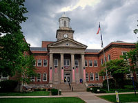 The Crawford County Courhouse in Meadville
Seal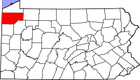
Location in the state of Pennsylvania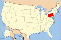
Pennsylvania's location in the U.S.Founded March 12, 1800 Seat Meadville Largest city Meadville Area
- Total
- Land
- Water
1,038 sq mi (2,688 km²)
1,013 sq mi (2,624 km²)
25 sq mi (65 km²), 2.41%Population
- (2010)
- Density
88,765
88/sq mi (33.8/km²)Website www.co.crawford.pa.us Crawford County is a county located in the U.S. state of Pennsylvania. As of 2010, the population was 88,765.
Crawford County was created on March 12, 1800, from part of Allegheny County and named for Colonel William Crawford. Its county seat is Meadville[1].
Contents
State Representation
Pennsylvania State Senate
District Senator Party 50 Robert Robbins Republican Pennsylvania House of Representatives
District Representative Party 5 John R. Evans Republican 6 Brad Roae Republican 17 Michele Brooks Republican Federal Representation
United States House of Representatives
District Representative Party 3 Mike Kelly Republican 5 Glenn "G.T." Thompson Republican United States Senate
Senator Party Pat Toomey Republican Bob Casey Democrat Geography
According to the U.S. Census Bureau, the county has a total area of 1,038 square miles (2,688.4 km2), of which 1,013 square miles (2,623.7 km2) is land and 25 square miles (64.7 km2) (2.41%) is water.
Adjacent Counties
- Erie County (north)
- Warren County (east)
- Venango County (southeast)
- Mercer County (south)
- Trumbull County, Ohio (southwest)
- Ashtabula County, Ohio (west)
National protected area
Recreation
Pymatuning State Park is on Pymatuning Reservoir.
Demographics
Historical populations Census Pop. %± 1800 2,346 — 1810 6,178 163.3% 1820 9,397 52.1% 1830 16,030 70.6% 1840 31,724 97.9% 1850 37,849 19.3% 1860 48,755 28.8% 1870 63,832 30.9% 1880 68,607 7.5% 1890 65,324 −4.8% 1900 63,643 −2.6% 1910 61,565 −3.3% 1920 60,667 −1.5% 1930 62,980 3.8% 1940 71,644 13.8% 1950 78,948 10.2% 1960 77,956 −1.3% 1970 81,342 4.3% 1980 88,869 9.3% 1990 86,169 −3.0% 2000 90,367 4.9% 2010 88,765 −1.8% [2][3] As of the census[4] of 2000, there were 90,366 people, 34,678 households, and 23,858 families residing in the county. The population density was 89 people per square mile (34/km²). There were 42,416 housing units at an average density of 42 per square mile (16/km²). The racial makeup of the county was 97.00% White, 1.59% Black or African American, 0.20% Native American, 0.28% Asian, 0.03% Pacific Islander, 0.13% from other races, and 0.77% from two or more races. 0.59% of the population were Hispanic or Latino of any race. 26.7% were of German, 11.7% American, 11.3% Irish, 10.8% English, 7.6% Italian and 5.4% Polish ancestry according to Census 2000.
There were 34,678 households out of which 30.40% had children under the age of 18 living with them, 55.60% were married couples living together, 9.20% had a female householder with no husband present, and 31.20% were non-families. 26.20% of all households were made up of individuals and 11.60% had someone living alone who was 65 years of age or older. The average household size was 2.50 and the average family size was 3.01.
In the county, the population was spread out with 24.70% under the age of 18, 9.20% from 18 to 24, 26.60% from 25 to 44, 23.90% from 45 to 64, and 15.60% who were 65 years of age or older. The median age was 38 years. For every 100 females there were 94.80 males. For every 100 females age 18 and over, there were 90.80 males.
Municipalities
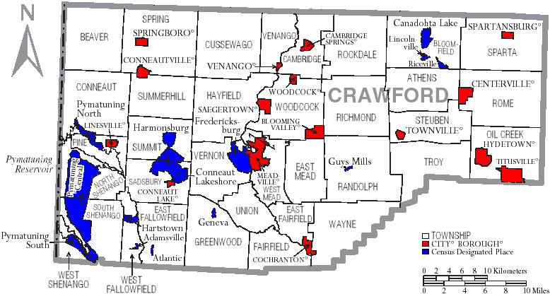
 Map of Crawford County, Pennsylvania with Municipal Labels showing Cities and Boroughs (red), Townships (white), and Census-designated places (blue).
Under Pennsylvania law, there are four types of incorporated municipalities: cities, boroughs, townships, and, in at most two cases, towns. The following cities, boroughs and townships are located in Crawford County:
Cities
Boroughs
Townships
- Athens Township
- Beaver Township
- Bloomfield Township
- Cambridge Township
- Conneaut Township
- Cussewago Township
- East Fairfield Township
- East Fallowfield Township
- East Mead Township
- Fairfield Township
- Greenwood Township
- Hayfield Township
- North Shenango Township
- Oil Creek Township
- Pine Township
- Randolph Township
- Richmond Township
- Rockdale Township
- Rome Township
- Sadsbury Township
- South Shenango Township
- Sparta Township
- Spring Township
- Steuben Township
- Summerhill Township
- Summit Township
- Troy Township
- Union Township
- Venango Township
- Vernon Township
- Wayne Township
- West Fallowfield Township
- West Mead Township
- West Shenango Township
- Woodcock Township
Census-designated places
Census-designated places are geographical areas designated by the U.S. Census Bureau for the purposes of compiling demographic data. They are not actual jurisdictions under Pennsylvania law.
Other localities
Like census-designated places, these have no official jurisdiction, but unlike census-designated places, these have no official role in other ways either. They are simply locations with traditional names.
Education
Colleges and universities
- Allegheny College, located in Meadville
- University of Pittsburgh at Titusville, a branch campus of the University of Pittsburgh, located in Titusville
 Map of Crawford County, Pennsylvania School Districts
Community, Junior and Technical Colleges
- Precision Manufacturing Institute (PMI)[5]
Public School Districts
- Conneaut School District
- Corry Area School District
- Crawford Central School District
- Jamestown Area School District
- Penncrest School District
- Titusville Area School District
- Union City Area School District
See also
- List of municipal authorities in Crawford County, Pennsylvania
- National Register of Historic Places listings in Crawford County, Pennsylvania
References
- ^ "Find a County". National Association of Counties. http://www.naco.org/Counties/Pages/FindACounty.aspx. Retrieved 2011-06-07.
- ^ http://factfinder2.census.gov
- ^ http://mapserver.lib.virginia.edu/
- ^ "American FactFinder". United States Census Bureau. http://factfinder.census.gov. Retrieved 2008-01-31.
- ^ "Precision Manufacturing Institute (PMI)". http://www.pmionline.edu. Retrieved 2007-04-07.
External links
- Crawford County Historical Society
- History of Townships in Crawford County, PA
- Crawford County's Historic Bridges
Municipalities and communities of Crawford County, Pennsylvania Cities 
Boroughs Blooming Valley | Cambridge Springs | Centerville | Cochranton | Conneaut Lake | Conneautville | Hydetown | Linesville | Saegertown | Spartansburg | Springboro | Townville | Venango | Woodcock
Townships Athens | Beaver | Bloomfield | Cambridge | Conneaut | Cussewago | East Fairfield | East Fallowfield | East Mead | Fairfield | Greenwood | Hayfield | North Shenango | Oil Creek | Pine | Randolph | Richmond | Rockdale | Rome | Sadsbury | South Shenango | Sparta | Spring | Steuben | Summerhill | Summit | Troy | Union | Venango | Vernon | Wayne | West Fallowfield | West Mead | West Shenango | Woodcock
CDPs Unincorporated
communitiesBuells Corners | Custards | Frenchtown
Categories:- Pennsylvania counties
- Crawford County, Pennsylvania
- 1800 establishments in the United States
- Populated places established in 1800


Wikimedia Foundation. 2010.