- Jefferson County, Pennsylvania
-
Jefferson County, Pennsylvania 
Location in the state of Pennsylvania
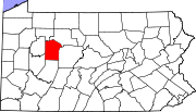
Pennsylvania's location in the U.S.Founded March 26, 1804 Seat Brookville Largest city Punxsutawney Area
- Total
- Land
- Water
657 sq mi (1,702 km²)
655 sq mi (1,696 km²)
1 sq mi (3 km²), 0.21%Population
- (2010)
- Density
45,200
69/sq mi (26.6/km²)Jefferson County is a county located in the U.S. state of Pennsylvania. In 2010, its population was 45,200. It was established on March 26, 1804, from part of Lycoming County and named for then-President Thomas Jefferson. Its county seat is Brookville[1]. It is home to Punxsutawney Phil, the groundhog that predicts when spring will come every February 2 (Groundhog Day).
Contents
Geography
According to the U.S. Census Bureau, the county has a total area of 657 square miles (1,701.6 km2), of which 655 square miles (1,696.4 km2) is land and 1 square mile (2.6 km2) (0.21%) is water.
Adjacent counties
- Forest County (north)
- Elk County (northeast)
- Clearfield County (east)
- Indiana County (south)
- Armstrong County (southwest)
- Clarion County (west)
Demographics
Historical populations Census Pop. %± 1810 161 — 1820 561 248.4% 1830 2,025 261.0% 1840 7,253 258.2% 1850 13,518 86.4% 1860 18,270 35.2% 1870 21,656 18.5% 1880 27,935 29.0% 1890 44,005 57.5% 1900 59,113 34.3% 1910 63,090 6.7% 1920 62,104 −1.6% 1930 52,114 −16.1% 1940 54,090 3.8% 1950 49,147 −9.1% 1960 46,792 −4.8% 1970 43,695 −6.6% 1980 48,303 10.5% 1990 46,083 −4.6% 2000 45,932 −0.3% 2010 45,200 −1.6% [2][3] As of the census[4] of 2000, there were 45,932 people, 18,375 households, and 12,862 families residing in the county. The population density was 70 people per square mile (27/km²). There were 22,104 housing units at an average density of 34 per square mile (13/km²). The racial makeup of the county was 98.97% White, 0.13% Black or African American, 0.16% Native American, 0.21% Asian, 0.01% Pacific Islander, 0.07% from other races, and 0.45% from two or more races. 0.41% of the population were Hispanic or Latino of any race. 31.1% were of German, 13.4% Italian, 10.8% American, 9.2% Irish and 7.8% English ancestry according to Census 2000.
There were 18,375 households out of which 30.30% had children under the age of 18 living with them, 56.80% were married couples living together, 9.10% had a female householder with no husband present, and 30.00% were non-families. 26.60% of all households were made up of individuals and 13.80% had someone living alone who was 65 years of age or older. The average household size was 2.45 and the average family size was 2.96.
In the county, the population was spread out with 23.60% under the age of 18, 7.70% from 18 to 24, 27.20% from 25 to 44, 23.60% from 45 to 64, and 17.90% who were 65 years of age or older. The median age was 40 years. For every 100 females there were 95.70 males. For every 100 females age 18 and over, there were 92.60 males.
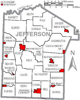 Map of Jefferson County, Pennsylvania with Municipal Labels showing Boroughs (red) and Townships (white).
Municipalities
Under Pennsylvania law, there are four types of incorporated municipalities: cities, boroughs, townships, and, in at most two cases, towns. The following boroughs and townships are located in County:
Boroughs
Townships
- Barnett Township
- Beaver Township
- Bell Township
- Clover Township
- Eldred Township
- Gaskill Township
- Heath Township
- Henderson Township
- Rose Township
- Snyder Township
- Union Township
- Warsaw Township
- Washington Township
- Winslow Township
- Young Township
Unincorporated community
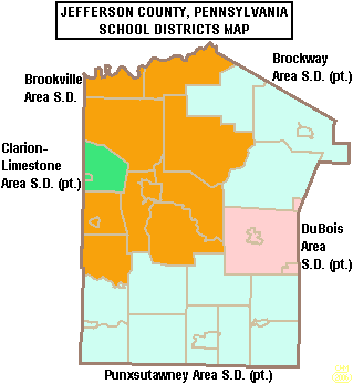
 Map of Jefferson County, Pennsylvania Public School Districts
Education
Colleges and universities
Public School Districts
- Brockway Area School District
- Brookville Area School District
- Clarion-Limestone Area School District
- DuBois Area School District
- Punxsutawney Area School District
Recreation
Two Pennsylvania state parks are in the county.
- Clear Creek State Park is in Barnett and Heath Townships.
- Cook Forest State Park is in Barnett Township and stretches into neighboring Clarion and Forest Counties
See also
- List of municipal authorities in Jefferson County, Pennsylvania
- National Register of Historic Places listings in Jefferson County, Pennsylvania
- Oil Creek Library District
References
- ^ "Find a County". National Association of Counties. http://www.naco.org/Counties/Pages/FindACounty.aspx. Retrieved 2011-06-07.
- ^ http://factfinder2.census.gov
- ^ http://mapserver.lib.virginia.edu/
- ^ "American FactFinder". United States Census Bureau. http://factfinder.census.gov. Retrieved 2008-01-31.
Municipalities and communities of Jefferson County, Pennsylvania Boroughs Big Run | Brockway | Brookville | Corsica | Falls Creek‡ | Punxsutawney | Reynoldsville | Summerville | Sykesville | Timblin | Worthville
Townships Unincorporated
communityFootnotes ‡This populated place also has portions in an adjacent county or counties
Categories:- Pennsylvania counties
- Jefferson County, Pennsylvania
- 1804 establishments in the United States
- Populated places established in 1804


Wikimedia Foundation. 2010.