- Marlboro County, South Carolina
-
Marlboro County, South Carolina 
Seal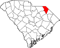
Location in the state of South Carolina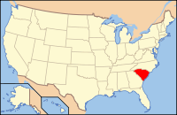
South Carolina's location in the U.S.Founded 1785 Seat Bennettsville Area
- Total
- Land
- Water
485 sq mi (1,256 km²)
480 sq mi (1,243 km²)
6 sq mi (16 km²), 1.15%Population
- (2010)
- Density
28,933
60/sq mi (23/km²)Website www.marlborocounty.sc.gov Marlboro County is a county located in the U.S. state of South Carolina. The 2000 census recorded its population to be 28,818. The 2005 census estimate placed the population at 28,021.[1] Its county seat is Bennettsville.[2]
Contents
History
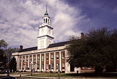 Marlboro County Courthouse, Bennettsville, South Carolina
The first inhabitants of what would become Marlboro County were the Pee Dee. The first Europeans to arrive in the area were Welsh settlers leaving Pennsylvania. In 1737, they established the first settlement which was called Welsh Neck.[3]
On 12 March 1785, Marlboro County was established by law. It was named for the Duke of Marlborough. Bennettsville, its county seat, was founded in 1819 as the city of Carlisle.[3]
Geography
According to the U.S. Census Bureau, the county has a total area of 485 square miles (1,260 km2), of which 480 square miles (1,200 km2) is land and 6 square miles (16 km2) (1.15%) is water.
Adjacent Counties
- Richmond County, North Carolina - north
- Scotland County, North Carolina - northeast
- Robeson County, North Carolina - east
- Dillon County, South Carolina - east
- Florence County, South Carolina - south
- Darlington County, South Carolina - southwest
- Chesterfield County, South Carolina - west
- Anson County, North Carolina - northwest
Demographics
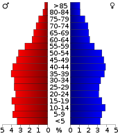 Marlboro County population distribution by age and sex, 2000 census
Historical populations Census Pop. %± 1900 27,639 — 1910 31,189 12.8% 1920 33,180 6.4% 1930 31,634 −4.7% 1940 33,281 5.2% 1950 31,766 −4.6% 1960 28,529 −10.2% 1970 27,151 −4.8% 1980 31,624 16.5% 1990 29,361 −7.2% 2000 28,818 −1.8% 2010 28,933 0.4% As of the census[4] of 2000, there were 28,818 people, 10,478 households, and 7,334 families residing in the county. The population density was 60 people per square mile (23/km²). There were 11,894 housing units at an average density of 25 per square mile (10/km²). The racial makeup of the county was 44.49% White, 50.73% Black or African American, 3.36% Native American, 0.24% Asian, 0.24% from other races, and 0.95% from two or more races. 0.71% of the population were Hispanic or Latino of any race.
There were 10,478 households out of which 32.00% had children under the age of 18 living with them, 42.60% were married couples living together, 22.20% had a female householder with no husband present, and 30.00% were non-families. 26.90% of all households were made up of individuals and 11.00% had someone living alone who was 65 years of age or older. The average household size was 2.59 and the average family size was 3.14.
In the county, the population was spread out with 26.20% under the age of 18, 9.30% from 18 to 24, 29.40% from 25 to 44, 22.80% from 45 to 64, and 12.30% who were 65 years of age or older. The median age was 35 years. For every 100 females there were 96.30 males. For every 100 females age 18 and over, there were 93.10 males.
The median income for a household in the county was $26,598, and the median income for a family was $32,019. Males had a median income of $25,896 versus $20,590 for females. The per capita income for the county was $13,385. About 17.70% of families and 21.70% of the population were below the poverty line, including 29.20% of those under age 18 and 22.70% of those age 65 or over.
Politics
Part of the Solid South, the county used to vote overwhelmingly Democratic, giving 100% of its vote to the party in 1924.[5] It has mostly remained solidly Democratic in the last 48 years, except for the 1972 election where Richard Nixon won every county in the state including Marlboro.[6] More recently the county went strongly for Barack Obama who received 62.4% of the vote in the 2008 U.S. presidential election. Further the Democratic candidate has received over 58% in all elections from 1992 to 2004.[7]
Cities and towns
- Bennettsville
- Blenheim
- Clio
- McColl
- Tatum
- Wallace
Transportation
Airports
- Marlboro County Jetport
- Myrtle Beach International Airport (MYR) 76.8 Miles South - South - East of Bennettsville
- Charlotte International Airport (CLT) 81.3 Miles West - North - West of Bennettsville
- Clio Crop Care Airport (9W9)
See also
References
- ^ http://www.census.gov/popest/counties/tables/CO-EST2005-01-45.xls
- ^ "Find a County". National Association of Counties. http://www.naco.org/Counties/Pages/FindACounty.aspx. Retrieved 2011-06-07.
- ^ a b Marlboro County “It’s Good to be Home”, January 2009. Bennettsville, SC: Marlboro Herald-Advocate. 2009. pp. 60.
- ^ "American FactFinder". United States Census Bureau. http://factfinder.census.gov. Retrieved 2008-01-31.
- ^ 1924 Presidential Election Statistics
- ^ David Leip Presidential Atlas (Election maps for South Carolina)
- ^ New York Times Electoral Map (Zoom in on South Carolina)
Municipalities and communities of Marlboro County, South Carolina City 
Towns Unincorporated
communityWallace
 State of South Carolina
Regions Larger cities Smaller cities Towns CDPs Counties - Abbeville
- Aiken
- Allendale
- Anderson
- Bamberg
- Barnwell
- Beaufort
- Berkeley
- Calhoun
- Charleston
- Cherokee
- Chester
- Chesterfield
- Clarendon
- Colleton
- Darlington
- Dillon
- Dorchester
- Edgefield
- Fairfield
- Florence
- Georgetown
- Greenville
- Greenwood
- Hampton
- Horry
- Jasper
- Kershaw
- Lancaster
- Laurens
- Lee
- Lexington
- Marion
- Marlboro
- McCormick
- Newberry
- Oconee
- Orangeburg
- Pickens
- Richland
- Saluda
- Spartanburg
- Sumter
- Union
- Williamsburg
- York
Topics - History
- Famous people
- Governors
- Legislature
- State House
- Congressional districts
- Census areas
- State parks
- Rivers
- Wildlife refuges
- Historic places
- Amusement parks
- Colleges and universities
- Sports venues
- Shopping malls
- Television stations
- Radio stations
- Highways
- Airports
- Visitor attractions
Categories:- South Carolina counties
- Marlboro County, South Carolina
- 1785 establishments
- Counties of the United States with African American majority populations


Wikimedia Foundation. 2010.