- Custer County, South Dakota
-
Custer County, South Dakota 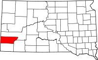
Location in the state of South Dakota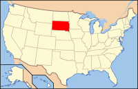
South Dakota's location in the U.S.Founded 1875 Seat Custer Area
- Total
- Land
- Water
1,559 sq mi (4,038 km²)
1,558 sq mi (4,034 km²)
1 sq mi (4 km²), 0.09%Population
- (2010)
- Density
8,216
4.67/sq mi (1.803/km²)Custer County is a county located in the U.S. state of South Dakota. As of the 2010 census, the population was 8,216. The county seat is Custer.[1]
Contents
Geography
According to the U.S. Census Bureau, the county has a total area of 1,559 square miles (4,037.8 km2), of which 1,558 square miles (4,035.2 km2) is land and 1 square mile (2.6 km2) (0.09%) is water. Wind Cave National Park is located within the county, as is Jewel Cave National Monument. South Dakota's own Custer State Park is also located in the county.
Townships
The county is divided into two areas of territory: East of Custer State Park and West of Custer State Park Custer.
Major highways
 U.S. Highway 16
 U.S. Highway 385
- U.S. Highway 16A
 South Dakota Highway 36
Adjacent counties
- Pennington County, South Dakota - north
- Shannon County, South Dakota - southeast
- Fall River County, South Dakota - south
- Niobrara County, Wyoming - southwest
- Weston County, Wyoming - west
National protected areas
- Black Hills National Forest (part)
- Buffalo Gap National Grassland (part)
- Jewel Cave National Monument
- Wind Cave National Park
Demographics
Historical populations Census Pop. %± 1880 995 — 1890 4,891 391.6% 1900 2,728 −44.2% 1910 4,458 63.4% 1920 3,907 −12.4% 1930 5,353 37.0% 1940 6,023 12.5% 1950 5,517 −8.4% 1960 4,906 −11.1% 1970 4,698 −4.2% 1980 6,000 27.7% 1990 6,179 3.0% 2000 7,275 17.7% 2010 8,216 12.9% U.S. Decennial Census As of the census[2] of 2000, there were 7,275 people, 2,970 households, and 2,067 families residing in the county. The population density was 5 people per square mile (2/km²). There were 3,624 housing units at an average density of 2 per square mile (1/km²). The racial makeup of the county was 94.17% White, 0.27% Black or African American, 3.12% Native American, 0.18% Asian, 0.01% Pacific Islander, 0.36% from other races, and 1.88% from two or more races. 1.51% of the population were Hispanic or Latino of any race. 32.2% were of German, 9.8% Irish, 9.2% English, 7.1% Norwegian and 5.7% American ancestry.
There were 2,970 households out of which 26.90% had children under the age of 18 living with them, 60.20% were married couples living together, 6.60% had a female householder with no husband present, and 30.40% were non-families. 25.90% of all households were made up of individuals and 10.30% had someone living alone who was 65 years of age or older. The average household size was 2.35 and the average family size was 2.80.
In the county, the population was spread out with 24.10% under the age of 18, 6.30% from 18 to 24, 22.40% from 25 to 44, 31.10% from 45 to 64, and 16.00% who were 65 years of age or older. The median age was 43 years. For every 100 females there were 104.40 males. For every 100 females age 18 and over, there were 99.40 males.
The median income for a household in the county was $36,303, and the median income for a family was $43,628. Males had a median income of $30,475 versus $20,781 for females. The per capita income for the county was $17,945. About 6.20% of families and 9.40% of the population were below the poverty line, including 13.00% of those under age 18 and 7.40% of those age 65 or over.
Cities and towns
National monument and park
State parks
See also
References
- ^ "Find a County". National Association of Counties. http://www.naco.org/Counties/Pages/FindACounty.aspx. Retrieved 2011-06-07.
- ^ "American FactFinder". United States Census Bureau. http://factfinder.census.gov. Retrieved 2008-01-31.

Pennington County Weston County, Wyoming 
 Custer County, South Dakota

Niobrara County, Wyoming Fall River County Shannon County Municipalities and communities of Custer County, South Dakota City 
Towns Buffalo Gap | Fairburn | Hermosa | Pringle
Unincorporated
communityFour Mile
Categories:- South Dakota counties
- Custer County, South Dakota
- Black Hills


Wikimedia Foundation. 2010.