- Culpeper County, Virginia
-
Culpeper County, Virginia 
Seal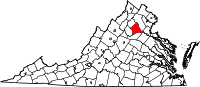
Location in the state of Virginia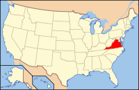
Virginia's location in the U.S.Founded 1749 Seat Culpeper Area
- Total
- Land
- Water
382 sq mi (989 km²)
381 sq mi (987 km²)
1 sq mi (3 km²), 0.33%Population
- Density
46,689
90/sq mi (34.7/km²)Website www.culpepercounty.gov Culpeper County is a county located in the Commonwealth of Virginia. As of 2010, the population was 46,689.[1] Its county seat is Culpeper[2].
Contents
History
Culpeper County was established in 1749 from Orange County. The county is named for Lord Thomas Culpeper. During the Civil War the Battle of Cedar Mountain took place on August 9, 1862 and the Battle of Brandy Station on June 9, 1863, in Culpeper County.
In May 1749, the first Culpeper Court convened in the home of Robert Coleman, not far from where the Town of Culpeper is presently located. In July 1749, 17-year-old George Washington was commissioned as the first County surveyor.[3] One of his first duties was to lay out the County's courthouse complex, which included the courthouse, jail, stocks, gallows and accessory buildings. By 1752 the complex stood at what is presently the northeast corner of Davis and Main Streets. The courthouse village was named the Town of Fairfax after Thomas, Sixth Baron Fairfax.[4][dead link]


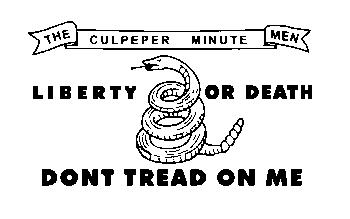
During the Virginia convention held in May 1775, the colony was divided into sixteen districts. Each district had instructions to raise a battalion of men "to march at a minute's notice." Culpeper, Orange and Fauquier, forming one district, raised 350 men in "Clayton's old field" on the Catalpa estate, who came to be called the Culpeper Minute Men. The Minute Men, marching under their flag depicting a rattlesnake and inscribed with the words "Liberty or Death" and "Don't Tread on Me", took part in the Battle of Great Bridge, the first Revolutionary battle on Virginia soil. The Culpeper Minute Men reorganized in 1860 in response to the impending Civil War and became part of 13th Infantry's Company B. The Culpeper Minutemen were again organized for World War I, and joined the 116th Infantry.
Andrew Stevenson, Speaker of the House of Representatives from 1827 to 1834, was born in Culpeper County on Jan. 21, 1784.
Over the past 25 years, the rural nature of Culpeper County has experienced increasing pressures from population growth due to the County's central location within the Northern Virginia region and the improved highway network that serves the area. Culpeper wishes to maintain its rural character and to avoid becoming a bedroom community to the nearby metropolitan area around Washington, D.C.[neutrality is disputed] However, the County recognizes not only the need to maintain but to expand its economic base to support and address the needs of the citizens of the County.[4][dead link]
Culpeper was home to baseball Hall of Famer Eppa Rixey. Culpeper also produced pro basketball player Keith "Mister" Jennings. Culpeper produced country music star Kenny Alphin of the group "Big & Rich".
Culpeper County is in the foothills of the Blue Ridge Mountains, which are quickly accessed beginning with Old Rag Mountain and the Skyline Drive just up Route 522.
Culpeper County is home to Commonwealth Park, site for many world-class equestrian events. It was here that actor Christopher Reeve suffered his accident during a competition.
Culpeper is home to famous battlefield at Brandy Station and the boyhood home to Civil War Gen. A.P. Hill.
The town of Culpeper was rated #10 by Norman Crampton, author of "The 100 Best Small Towns in America," in February, 1993.
Geography
According to the U.S. Census Bureau, the county has a total area of 382 square miles (989.4 km2), of which 381 square miles (986.8 km2) is land and 1 square mile (2.6 km2) (0.33%) is water.
Adjacent counties
Stafford County, Virginia - East
Orange County, Virginia - South
Madison County, Virginia - Southwest
Rappahannock County, Virginia - Northwest
Spotsylvania County, Virginia - Southeast
Fauquier County, Virginia - NortheastDemographics
Historical populations Census Pop. %± 1790 22,105 — 1800 18,100 −18.1% 1810 18,967 4.8% 1820 20,944 10.4% 1830 24,027 14.7% 1840 11,393 −52.6% 1850 12,282 7.8% 1860 12,063 −1.8% 1870 12,227 1.4% 1880 13,408 9.7% 1890 13,233 −1.3% 1900 14,123 6.7% 1910 13,472 −4.6% 1920 13,292 −1.3% 1930 13,306 0.1% 1940 13,365 0.4% 1950 13,242 −0.9% 1960 15,088 13.9% 1970 18,218 20.7% 1980 22,620 24.2% 1990 27,791 22.9% 2000 34,262 23.3% 2010 46,689 36.3% As of the census[5] of 2000, there were 34,262 people, 12,141 households, and 9,045 families residing in the county. The population density was 90 people per square mile (35/km²). There were 12,871 housing units at an average density of 34 per square mile (13/km²). The racial makeup of the county was 78.27% White, 18.15% Black or African American, 0.33% Native American, 0.66% Asian, 0.01% Pacific Islander, 1.15% from other races, and 1.43% from two or more races. 2.50% of the population were Hispanic or Latino of any race.
 U.S. Route 211 as it passes through Culpeper County
There were 12,141 households out of which 35.00% had children under the age of 18 living with them, 58.50% were married couples living together, 11.30% had a female householder with no husband present, and 25.50% were non-families. 20.60% of all households were made up of individuals and 7.90% had someone living alone who was 65 years of age or older. The average household size was 2.68 and the average family size was 3.08.
In the county, the population was spread out with 25.70% under the age of 18, 8.10% from 18 to 24, 31.10% from 25 to 44, 23.30% from 45 to 64, and 11.90% who were 65 years of age or older. The median age was 36 years. For every 100 females there were 103.30 males. For every 100 females age 18 and over, there were 103.20 males.
The median income for a household in the county was $45,290, and the median income for a family was $51,475. Males had a median income of $36,621 versus $25,985 for females. The per capita income for the county was $20,162. About 7.00% of families and 9.20% of the population were below the poverty line, including 10.30% of those under age 18 and 8.60% of those age 65 or over.
Schools
Culpeper County Public Schools http://www.culpeperschools.org
Elementary Schools
- A.G. Richardson Elementary
- Emerald Hill Elementary
- Farmington Elementary
- Pearl Sample Elementary
- Sycamore Park Elementary
- Yowell Elementary
Middle Schools
- Culpeper Middle
- Floyd T. Binns Middle
High Schools
- Culpeper County High School
- Eastern View High School
Communities
Town
Unincorporated communities
- Alanthus
- Boston
- Brandy Station
- Buena
- Cardova
- Catalpa
- Edward's Shop
- Eggbornsville
- Eldorada
- Elkwood
- Griffinsburg
- Jeffersonton
- Kellys Ford
- Lignum
- Mitchells
- Rapidan
- Reva
- Richardsville
- Rixeyville
- Stevensburg
- Winston
See also
References
- ^ [1]. Weldon Cooper Center 2010 Census Count Retrieved September 9, 2011
- ^ "Find a County". National Association of Counties. http://www.naco.org/Counties/Pages/FindACounty.aspx. Retrieved 2011-06-07.
- ^ Abbott, W.W., editor. The Papers of George Washington: Colonial Series, Volume 1 (University Press of Virginia: 1983) p.9
- ^ a b Culpeper County Comprehensive Plan, 2005[dead link]
- ^ "American FactFinder". United States Census Bureau. http://factfinder.census.gov. Retrieved 2008-01-31.
External links
- Culpeper County Government
- Culpeper County Public Schools
- Culpeper Regional Hospital
- Culpeper Chamber of Commerce
- Culpeper Restaurants
- Culpeper County During the Civil War in Encyclopedia Virginia

Rappahannock County Fauquier County 
Stafford County  Culpeper County, Virginia

Madison County Orange County Spotsylvania County Municipalities and communities of Culpeper County, Virginia Town 
Unincorporated
communitiesBoston | Brandy Station | Rapidan | Reva | Richardsville | Somerset | Stevensburg
Categories:- Virginia counties
- Culpeper County, Virginia
- 1749 establishments


Wikimedia Foundation. 2010.