- Lavant, West Sussex
-
Coordinates: 50°52′18″N 0°46′56″W / 50.87162°N 0.78236°W
Lavant 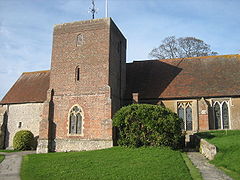
Church of St. Mary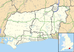
 Lavant
Lavant shown within West SussexArea 16.53 km2 (6.38 sq mi) [1] Population 1,586 [1] 2001 Census - Density 96 /km2 (250 /sq mi) OS grid reference SU857087 - London 52 miles (84 km) NNE Parish Lavant District Chichester Shire county West Sussex Region South East Country England Sovereign state United Kingdom Post town CHICHESTER Postcode district PO18 Police Sussex Fire West Sussex Ambulance South East Coast EU Parliament South East England UK Parliament Chichester Website http://www.lavantpc.org.uk/ List of places: UK • England • West Sussex Lavant is a civil parish in the Chichester district of West Sussex, England, just north of Chichester. It is made up of three villages, Mid Lavant and East Lavant together with the much smaller West Lavant, and takes its name from the River Lavant which flows from East Dean. East Lavant has a collection of historic cottages and a public house.[2]
The A286 road between Chichester and Midhurst runs through the parish.
The villages were served by a station on the railway line that ran between Chichester and Midhurst, but this closed in stages between 1931 and 1991.
Landmarks
Kingley Vale lies on the border of the parish which is a Site of Special Scientific Interest and a National Nature Reserve. It is noted for its Yew woodlands.[3] The site is also known for its archaeological interest including Bronze Age and Roman earthworks, cross dykes, a camp and a field system.
References
- ^ a b "2001 Census: West Sussex – Population by Parish". West Sussex County Council. http://www.westsussex.gov.uk/communityandliving/census2001/pop_parish_summary.pdf. Retrieved 5 May 2009.
- ^ Chichester Web - The Chichester Guide
- ^ (PDF) SSSI Citation — Kingley Vale. Natural England. http://www.english-nature.org.uk/citation/citation_photo/1002819.pdf. Retrieved 4 April 2009.
Categories:- Chichester (district)
- Civil parishes in West Sussex


Wikimedia Foundation. 2010.